


Display Type, Show Meta Object, Display Soundings, Display Cell Number, Display Text Message、Localization Display Text、Display Safety Contour Label、Display Other Contour Label、 Associated with Minvisible Scale and other functional controls.
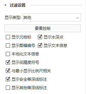 |
| Figure: Display Filter "Group |
Display Type
The Display Type Drop-down Button is used to set the Display Mode of the chart. There are three display modes: Standard, Basic, and Other. Where, Standard Display Type refers to the default chart display content, Basic Display Type only displays the content that cannot be deleted under any circumstances, and Other Display Type refers to the content that needs to be displayed by the user, such as water depth point, meta object, Text Info, etc.
Element Settings
Element Settings is used to control the Display Method of each object element in the current Map, including Displayable and Selectable. If the Selectable check box is checked, the object element is visible in the current Map. If the Selectable check box is checked, the object element can be selected in the current Map. For the specific control scheme of the object element, please refer to Object Element Display Control .
 |
| Figure: Element Settings |
Show MetaObject
Show MetaObject is used to control whether to show MetaObject in the current Map. MetaObject is a feature object that contains information shared by other objects. Available only when the display category is Other. If the check box is checked, it means Show MetaObject; otherwise, it is not displayed.
Display Soundings
Display Soundings is used to control whether to display the Soundings value in the current Map. It is only available when the display category is Other. If the check box is checked, it indicates the Display Soundings value; otherwise, it is not displayed.
Display Cell Number
Display Cell Number Used to control whether to Display Cell Number in the current Map. If the check box is selected, it means Display Cell Number; otherwise, it is not displayed.
Display Text Message
Display Text Message is used to control whether to display a text message in the current Map. If the check box is checked, it means Display Text Message; otherwise, it is not displayed.
Localization Display Text
Localization Display Text is used to control whether the Text Info of the object in the current Map is displayed in a localized manner. It is available when Display Text Message is checked. If the check box is checked, the Localization Display Text is displayed; otherwise, it is not displayed.
Display Low Accurate Marker
Display Low Accurate Marker is used to control whether the low-precision symbol is displayed in the Map. If the check box is checked, it means Display Low Accurate Marker; otherwise, it is not displayed. The QUAPOS field is generally used in the actual measured Chart Data to indicate the precision or reliability of the data, and the display of these data may have low precision symbols. The LOWACC01 symbol is used for display in the S52 standard.
Associated with Minvisible Scale
Associated with Minvisible Scale is used to control whether the object in the current Map is displayed with the enlargement and reduction of the chart. If this check box is selected, it means that the object will not be displayed when the Minimum Visible Scale of the object is greater than scale of Current Map; otherwise, the object will be displayed.
Display Safety Contour Label
Display Safety Contour Label is used to control whether to Display Safety Contour Label in the current Map. If the check box is checked, it indicates Display Safety Contour Label; otherwise, it is not displayed.
Display Other Contour Label
Display Other Contour Label is used to control whether to Display Other Contour Label in the current Map. If the check box is checked, it indicates Display Other Contour Label; otherwise, it is not displayed.