


Instructions for use
The Element Settings window is used to control the Display Status of the object elements in the current Chart Window, including Displayable and Selectable Display Status. The former controls whether the object elements are visible, and the latter controls whether the object elements can be selected. O as to carry out relevant operation.
Operation steps
- Open the chart Dataset Group in Map.
- In the Properties group of the Map tab, click the Nautical Chart Properties button, and in the Nautical Chart Properties panel that pops up, Click the Element Settings button in the Filter Settings area to pop up the Element Settings dialog as shown in the following figure.
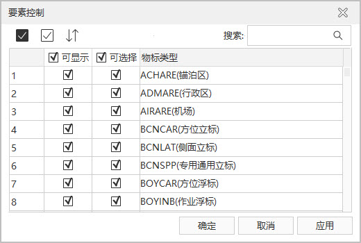
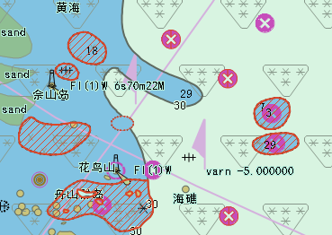
Figure: Object Feature Control Window Alternatively, in the Nautical Chart Properties group of the Chart tab, click Nautical Chart Properties to open the Nautical Chart Properties panel.
- Related Parameter Description: Description of
toolbar buttons:
 Button: select all records in the list box.
  Button: Cancel the selected record in the list and select the record that has not been selected before.
  Button: Restores all the settings in the dialog box to what they were when the interface was loaded, but does not work for Search Results.
Object Type List Description:
- Displayable: control whether the object element is visible in the current Map. By default, all object elements in the current Map can be displayed.
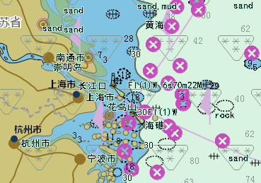
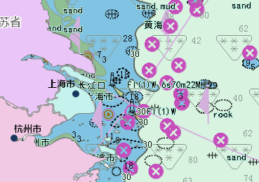
Users can customize the visibility of the object elements of the chart according to different requirements, and set the irrelevant object elements to be hidden, so that the chart is more concise and easy to view. For example, when making Chart Data, the information of the ocean on the earth's surface and the land adjacent to it will be drawn at the same time. When using it, the chart and the land chart need to be used together. At this time, the area describing the land in the chart needs to be hidden to achieve the desired Display Effects. Therefore, the user can set the land area Object Type as non-displayable to hide all the land area Object Types in the Current Map.
As shown in the figure below, the chart is superimposed on the land map, and the left figure shows the map without the land area object Display Control. At this time, the land map is completely covered by the chart, so that the user cannot obtain the relevant information of the land map. The right figure shows the Display Effects after the land area of the chart is set to be non-displayable (that is, the "displayable" state before the Land Area Object Type is cancelled). At this time, the relevant information of the chart and the land chart can be seen at the same time.
- Optional: It is used to control whether the object element can be selected in the current Map, so as to carry out further operations on the selected Object Type. By default, all object elements in the current Map can be selected.
In addition, you can click on an empty area with the mouse or use the ESC shortcut Deselect.
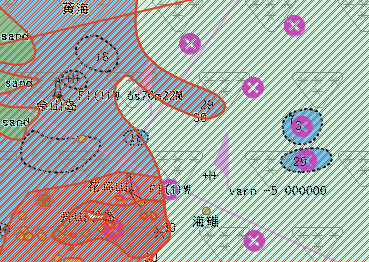
The object elements of thechart are all superimposed on one chart. When one or more object elements are selected, multiple object elements may be selected at the same time, which increases the complexity of the operation. Therefore, you can cancel the "selectable" status of the object elements that you do not want to view, so that you can accurately and easily select the object object you want to further view or edit its Attributes.
As shown in the figure below, the left figure is the schematic diagram of the result of selecting the object element of the obstacle in the default state of the current chart (that is, all the object elements are selectable), and the right figure is the schematic diagram of the result of selecting the object element when only the obstacle is set to be selectable.
- Object Type: display all object feature types contained in the current Map.
When controlling the Display Method of an object element, the user can select an Object Type and set the Display Control mode of the Object Type; You can also select multiple Object Types with the shift key or CTRL key to set Display Control in batches. After multiple Object Types are selected, when the Display Method of one of the Object Types is modified, the other selected Object Types will have the same change at the same time.
According to the logical sequence of the Display Control mode of the object element, the "selectable" of the object depends on the change of the "displayable", that is, when the object element is visible in the current Map, you can continue to set whether the object element can be selected. Therefore, in the "Element Settings" window, only after the "Displayable" attribute of the object element is checked, the "Selectable" attribute can be checked, otherwise the "Selectable" attribute is not available.
- After the
object element Display Method is modified, click the Apply button at the bottom right of the Element Settings "window to view the modification effect in the current Map.