


The Coordinate System section of Map Properties is used to set and display the current coordinate system of the map. The toolbar allows resetting coordinate system, copying coordinate system, importing/exporting coordinate systems, setting transformation parameters, and enabling dynamic projection.
Reset Coordinate System
The Reset Coordinate System drop-down button provides seven commonly used coordinate system options for quick assignment. If these don't meet your requirements, use the More option to access the Coordinate System Settings dialog for selecting predefined systems or creating custom ones. For detailed operations, refer to Coordinate System Settings.
Copy Coordinate System
Click Copy Coordinate System to open the Copy Coordinate System dialog, offering two options:
- From Datasource: Check this option to select a datasource, and the program will automatically set its coordinate system as the target coordinate system.
- From Dataset: Check this option to first specify a datasource and then select a dataset. The system will use the dataset's coordinate system as the target.
Import Coordinate System
Select Import Coordinate System... from the import/export drop-down menu, then choose a coordinate system file in the Select dialog.
Supported formats include: Shapefile projection info file (*.shp;*.prj), MapInfo Exchange Format (*.mif), MapInfo TAB File (*.tab), image projection info file (*.tif;*.img;*.sit), and projection info file (*.xml).
Export Coordinate System
Select Export Coordinate System... from the import/export drop-down menu to export current coordinate system information as an XML file.
Transformation Parameters
When Dynamic Projection is enabled, use transformation parameters to dynamically project datasets added to the current map. Conversion between planar and geographic coordinate systems is not supported.
Click Transformation Parameters to configure these settings in the Parameter Settings dialog:
- Transformation Method: Select a reference frame conversion method from the dropdown. For details, see Reference Frame Conversion Methods.
- Scale Difference: Represents scaling factor between source and target coordinate systems. Required for planar coordinate system conversions. Calculated as: source-to-target unit conversion * 1,000,000. E.g., millimeter-to-meter conversion requires 1000 scale difference.
- Rotation Angle: Rotation angles around X/Y/Z axes. Default: 0. Unit: dms.
- Offsets: Translation values along X/Y/Z axes. Default: 0. Unit: m.
- Origin Coordinates: Rotation origin coordinates (X/Y/Z). Default: 0.
- Import: Load parameters from *.ctp projection transformation file to apply saved settings.
- Export: Save current parameters to specified path for reuse.
Dynamic Projection
Dynamic projection automatically converts subsequently loaded datasets to match the map's current coordinate system, enabling proper overlay display of data with different projections.
Check this box to enable dynamic projection; uncheck to disable it.
Web maps (including OGC, SuperMap Cloud services, Google Maps, etc.) currently don't support dynamic projection.
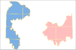
As shown below, regional data stored in two datasets with different projections will display separately without dynamic projection. When enabled, both datasets use unified projection for proper overlay.
 |
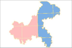 |
| Figure: Dynamic Projection Disabled | Figure: Dynamic Projection Enabled |
Related Topics
Map Properties - Basic Settings
Map Properties - Extent Settings