


Manages coordinate projections for data sources, datasets, or maps. The dialog contains: ribbon, manage directory tree, file list, description area, and scope of application preview area.
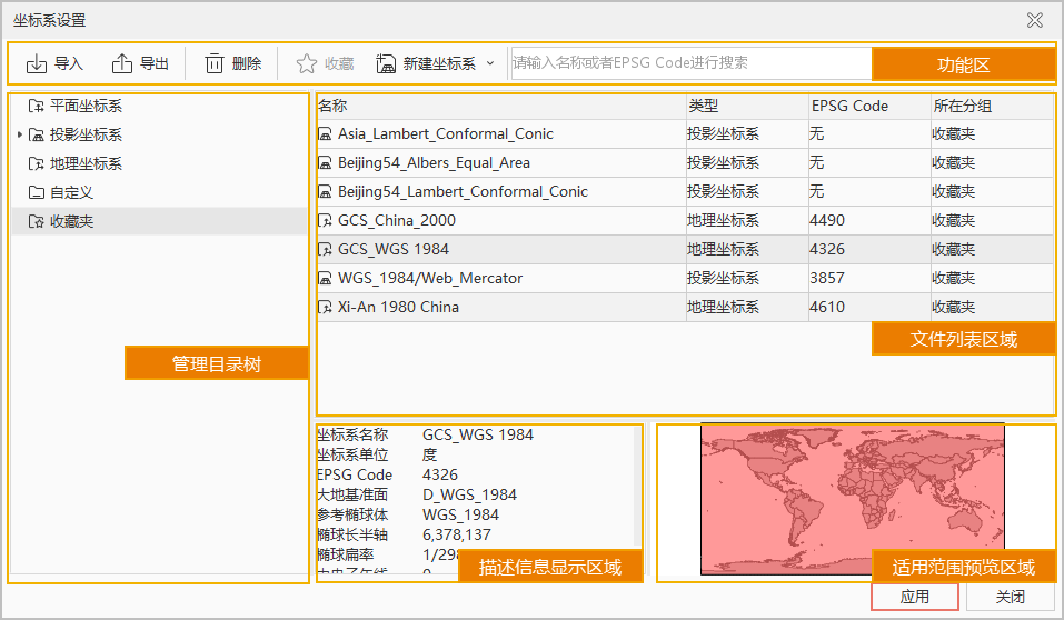 |
| Figure: Coordinate System Settings Dialog |
Ribbon
Located at the top of the Coordinate System Settings dialog, provides functions including Import, Export, Delete, New Coordinate System, and Search.
- Import: Click Import to open the Import Coordinate System File dialog. Specify the path of coordinate system files and click OK to load. Supported formats: Raster coordinate files (*.tif;*.sit;*.img), Shapefile coordinate files (*.shp;*.prj), MapInfo Exchange Format (*.mif), MapInfo TAB File (*.tab), and XML coordinate files (*.xml).
- Export: Select one or multiple coordinate systems, click Export to open Select Export Folder dialog. Specify target folder and confirm. The system will automatically export selected coordinate systems as XML files with auto-generated names.
- Delete: Only supports deleting coordinate systems from Custom or Favorites. Select one or multiple systems in file list and click Delete.
- Favorite: Add frequently used coordinate systems to Favorites for quick access. Steps:
- Select target coordinate system(s): Choose one or multiple systems in file list, click Favorite to open Add to Favorites dialog.
- Configure coordinate system: Modify parameters in dialog (disabled when multiple systems are selected).
- Select favorite group: Default to Favorites folder. Click New Folder to create and select new subfolder.
- Click Add to complete. Added systems can be viewed in Favorites section of directory tree.
- New Coordinate System: Supports creating Geographic Coordinate System, Projected Coordinate System, EPSG Code-based System, and WKT to Proj conversion.
- Search: Input strings or EPSG codes in search box to filter coordinate systems by name.
Manage Directory Tree
Organizes coordinate systems into groups for quick access, including Planar, Geographic, Projected, Custom, and Favorites. Only Favorites group supports subfolder creation.
File List Area
Displays all files under selected group in directory tree.
Description Area
- Displays detailed parameters (units, datum, reference spheroid, prime meridian) when single coordinate system is selected.
- Shows group name and selected file count when multiple systems are selected.
- Displays folder name and contained file count when directory group is selected.
Scope of Application Preview
Displays applicable area of selected coordinate system using red rectangle.
No preview shown for:
- Planar coordinate systems
- Projected/Geographic systems without EPSG code
- Custom systems not based on valid EPSG codes
Context Menu Functions
Provides 12 functions via right-click in directory tree/file list: Copy, Paste, Go To, Sort by Name, New Group, New Coordinate System, Modify, Rename, Delete, Import, Export, and Favorite. Available functions vary by selection:
- Copy: Available when coordinate files are selected in file list.
- Paste: Available when Custom/Favorites group is selected and clipboard contains data. Pastes files to selected group.
- Go To: Available after search operations. Quickly locates selected system's group in directory tree.
- New Group: Available in Favorites section. Creates "New Folder" subfolder.
- New Coordinate System: Supports creating new systems or modifying existing ones. New systems are stored in Custom group.
- Modify: Available for single system in Custom group.
- Rename: Available for systems in Custom/Favorites groups.
- Delete: Available for systems in Custom/Favorites groups.
- Import: Available when Custom group is selected.
- Export: Exports selected systems as XML files to specified folder.
- Favorite: Adds selected system(s) to Favorites.
Related Topics
Create Geographic Coordinate System
Create Projected Coordinate System