


This page describes loading GIS data through SuperMapGIS components, including three ways: loading local data, loading online services, and loading public services.
Load local data
This product supports loading local 3D tile data and data sets through Local Layer of Add Layer module in SuperMapGIS component, so as to load local terrain, image, oblique photography 3D model, point cloud, BIM, city fine model, building white model, underground pipeline and 3D point line surface data in Unity.
Supported 3D tile data types include: 3D image tile data (*sci3d), 3D terrain tile data (*.sct), 3D model tile data (*.scp).
Data sets can be added via data sources in *.udbx/*.udb format. Supported data set types include 3D point data set, 3D line data set, 3D surface data set and model data set.
Operating steps
- On the SuperMapGIS Component Add Layer Select Local Layer page, clickSelect File to pop up the Select Layer dialog box.
- After selecting the data, click Open to display information about the layer path of the specified data in the panel.
- When UDBX data is added, the dataset name is displayed and the drop-down menu allows you to select the dataset to add.
- After setting the relevant parameters, click the Add Layer button to load the data, and the Layer Manager will also add the corresponding layer information.
- The Clear button clears the existing layer information.
Loading online services
This product supports adding online services published through SuperMap iServer and other Rest services through the Add Layers module in SuperMapGIS components.
Support loading online terrain, image, oblique photography 3D model, point cloud, BIM, city fine model, white model, 3D pipeline and other data by adding "online service".
Operating steps
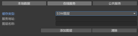
- Tile Type: Select the appropriate tile type according to the type of data added.
- When loading 3D model tile data (*.scp), select the S3M layer.
- When loading 3D terrain tile data (*.sct), select the terrain layer.
- When loading 3D image tile data (*.sci3d), select the image layer.
- When loading the map service, select Map.
- In addition to the above online services, it also supports loading other Rest services.
- Service address: Enter the service address where the data is located, for example:http://localhost:8090/iser/3D-test/rest/realspace .
- Layer Name: Enter the name of the layer where the data resides. When loading the S3M layer, terrain layer, and image layer, the layer name is set to the name of the layer under the first 3D scene.
- Click Add to load online data, and the layer management module will add relevant layer information. Click Clear to clear the added layer of related information.
Loading Common Services
This product supports adding public services such as SuperMap Terrain Service, BingMaps Service, STK Terrain Service, Sky Map Image, WMS, WMTS, etc. through the public services of the Add Layer module in SuperMap Editor Component.
Operating steps
- Click SuperMap Editor Component - Add Layer - Common Services , and the panel switches to the Load Common Services Settings page.
- According to the data type, select the corresponding service type and set the relevant parameters.
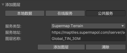
- In the process of using, if only free public services are used, except WMS and WMTS services, default parameters can be used, and directly click Add Layer to add corresponding data. If you are using a purchased public service, such as a high-precision sky map image, after selecting the corresponding service type, you need to fill in the purchased service address, layer name and other information, and then click Add Layer to add the corresponding data.
- SuperMap Terrain: Select the service type when adding a SuperMap Terrain service.
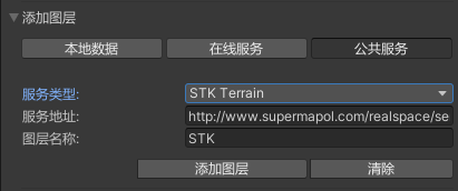
- STK Terrain: Select the service type when adding STK World Terrain.
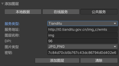
- Tian Map: Select this service type when adding a sky map image. Select the appropriate image type as needed, including BMP, JPG, JPG_PNG.
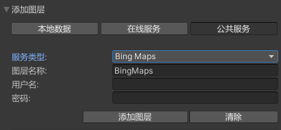
- Bing Maps: When adding a Bing Maps service, select the service type. Enter your username and password as needed.
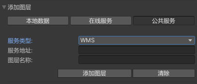
- WMS: When adding a WMS service, select the service type. The WMS service address published by SuperMap iServer needs to be filled in for the service address , for example:http//localhost:8090/iserver/services/maps/wms111/World. The layer name is automatically populated based on the service address.
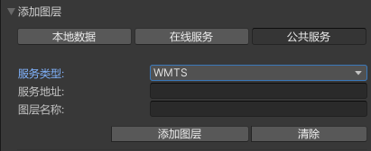
- WMTS: When adding a WMTS service, select the service type. For service address , fill in the WMTS service address published by SuperMap iServer, for example:http//localhost:8090/iserver/services/maps/wmts100 . The layer name needs to be obtained in the service address.
|
Notes: |