


The "Properties" tab of the "Label Thematic Map" window is mainly used to set the display parameters for the label objects (text) in the current label thematic map. It should be noted that the "Properties" tab parameters of the uniform label thematic map, ranges label thematic map, and custom style label thematic map are the same.
- Label Expression
Used to specify the thematic variable used by the current label thematic map. This thematic variable determines the text content of the label objects displayed on the label thematic map. The thematic variable can be a single property field or a mathematical expression of fields.
- The drop-down list of the combo box lists all property field names of the vector dataset used to create the current label thematic map. By default, the field alias is displayed, which can be switched to the field name in the File tab -> Options group. For details, refer to the Preferences document. You can select any field to change the thematic variable used by the current label thematic map. You can also type a field name in the combo box, but the field must exist in the drop-down list. After the field is determined, the current label thematic map will use the new thematic variable to re-label the objects in the layer.
- If you want to use a mathematical expression of a property field as the thematic variable of the label thematic map, select the "Expression..." item in the drop-down list of the combo box. In the pop-up "SQL Expression" dialog box, build the mathematical expression of the property field. After the field expression is built, the current label thematic map will use the new thematic variable to re-label the objects in the layer.
- If you want to use a concatenation operator to display multiple fields, select the "Expression..." item in the drop-down list of the combo box. In the pop-up "SQL Expression" dialog box, build the expression of the property field. After the field expression is built, the current label thematic map will use the new thematic variable to re-label the objects in the layer. For detailed information about field expressions, see Label Thematic Map Label Expression Description.
Notice
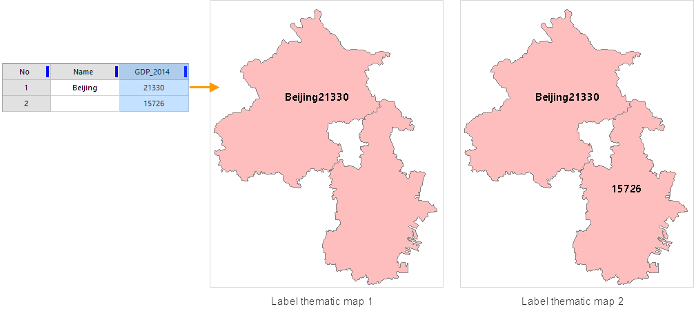
- If the field expression is a concatenation of multiple fields through SQL Expression, and the fields involved in the concatenation include a text field, when the value of the text field is null, the set thematic map labels will be considered invalid and cannot be displayed normally, because SQL Expression does not support operations with null values. As shown in the figure below: The two concatenated fields are Name (text field) and GDP_2000. Since the Name field value of object 2 is null, the label of that object is not displayed normally, as shown in Figure 1.
- When the text field is null and the label cannot be displayed normally as described above, it is recommended that you first check whether the field value is null when building the SQL Expression. If the value is null, return an empty string so that the label can be displayed normally. For example, in a MySQL database, use the ifnull function to check for null: ifnull(Name,"") || GDP_2000. If Name is not null, the ifnull function returns Name; otherwise, it returns the string "". This results in the label thematic map shown in Figure 2. Different databases have different functions for checking null values; please use the correct function according to the specific database in use.
- When creating a thematic map with Oracle Plus or SQL Plus engine type data, the field expression can only be a field value or a field operation expression, such as (SmID) or (SmID + 1). Currently, setting thematic map fields via conditional expressions is not supported. If the set field expression is a conditional expression, such as "SmID > 100", the thematic map creation will fail.
- In a label thematic map, if the label expression uses a complex composite expression (e.g., NAME [/] 'Length:' || SHAPE_Leng), the "Label Alongline" style is temporarily not supported.
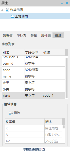
- Labels Are Enumeration Information
The field selected by the label expression must have its value domain set. The steps for domain settings are as follows:
Right-click the dataset -> Properties, in the Properties page that appears on the right -> Range tab, set the domain information for the field.
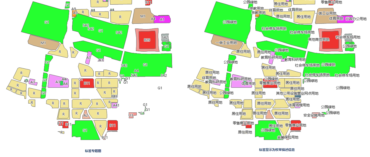
Comparison of label display effects with or without checking the "Labels Are Enumeration Information." option is shown below:
- "Background Settings" Area
Used to add a background with a specified shape and style to the label objects (text) in the label thematic map. This background is the background of the text, different from the background of the text characters.
Background Shape: Controls the background shape of the text. By selecting items in the drop-down list of the combo box, you can add a background to the text. The main forms of background shapes are:
- Default: The text in the label thematic map has no background shape decoration.
- Rectangle, Rounded Rectangle, Ellipse, Diamond, Triangle: Using one of these five shapes will apply the corresponding graphic as the background shape of the text in the label thematic map. At the same time, the "Settings" button for background style below becomes available to set the background style of the text in the label thematic map.
- Point Symbol: The text in the label thematic map uses a point symbol as its background.
Background Style: Controls the style of the text background shape. Click the "Settings" button on the right to set the background style of the text in the label thematic map. When the background shape is Rectangle, Rounded Rectangle, Ellipse, Diamond, or Triangle, the Fill Symbol Style Settings dialog box pops up; when the background shape is Point Symbol, the Point Symbol Style Settings (Map and Layout) dialog box pops up.
Background Margin: Sets the distance between the text and the background border of the label. Enter a value directly in the numeric box; the unit is pixels. Note: The background margin can only be set when the background shape is set to Rectangle or Rounded Rectangle and the background style is System 0 or System 1.
Background Shadow: After setting the background shape, you can set the color, offset X, and offset Y of the background shadow.
- Color: Sets the color of the background shadow; the default is gray (FF7F7F7F).
- Offset X: Sets the horizontal offset of the background shadow.
- Offset Y: Sets the vertical offset of the background shadow.
- Offset Settings Area
Used to adjust and control the display effects of the label objects (text) in the label thematic map.
- Offset Unit: Sets the unit for the offset value. Click the drop-down button on the right; the system provides two offset units: "Unit" and "0.1mm". "0.1mm" means the offset is in 0.1mm units; "Unit" means the offset is consistent with the map coordinate system units.
- Offset X: Sets the horizontal offset of the label relative to its represented object. You can directly enter a value to set the offset; or select a numeric field of the layer and use the field value as the offset.
- Vertical Offset: Sets the vertical offset of the label relative to its represented object. You can directly enter a value to set the offset; or select a numeric field of the layer and use the field value as the offset.
Note: When setting the offset by specifying a field, it is only effective for point label thematic maps.
- Show Leader Line:
If this check box is checked, when the label is offset from its labeled object, a leader line can be used to connect them.
- Line Style: Sets the style of the leader line. Supports three types: Straight Line, Three-Point Polyline, and Right-Angle Polyline.
- Line Symbol: Sets the style of the leader line. Click this button to open the Styles window, where you can set the line symbol style. For details, see: Line Symbol Style Settings
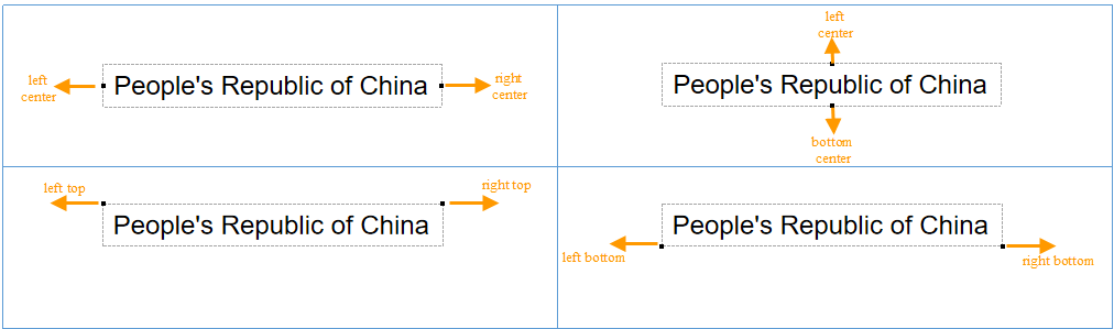
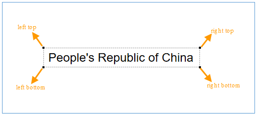
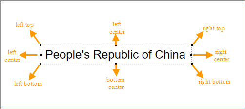
- Leader Line Anchor: Sets the starting point position of the leader line, i.e., which direction of the object it is located. If the Line Style is a regular polyline, setting the leader line anchor is not supported. Provides nine anchor point settings: Adaptive, Top Center, Top Right, Left Center, Center, Right Center, Bottom Left, Bottom Center, Bottom Right. If Adaptive is selected, the system will automatically calculate and select the anchor point among the eight anchors (Top Center, Top Right, Left Center, Center, Right Center, Bottom Left, Bottom Center, Bottom Right) that is closest to the original anchor point of the leader line.
- "Effect Settings" Area
Used to adjust and control the display effects of the label objects (text) in the label thematic map.
- Flow: Check this check box to enable the flow display of the thematic map rendering style, i.e., labels will move as the map changes to achieve an optimized display effect. When the flow effect is turned on, do not use the partial refresh function, otherwise partial refresh effects may be displayed incorrectly (SuperMap iDesktopX does not support the partial refresh function). Note: The flow function is not supported when creating a label thematic map on a point layer.
- Superscript/Subscript: Check this check box to achieve superscript/subscript display effects based on the rules set in the label expression. When using superscript/subscript, note the following issues:
- Superscript/subscript does not currently support parameters such as label alongline, rotation angle, and new line display.
- Superscript/subscript does not currently support label expressions with separators.
- Font effects such as strikethrough and underline do not support superscript/subscript.
For more information about superscript/subscript, see the Superscript/Subscript page.
- Show Slivers: Check this check box to display labels corresponding to small objects in the label thematic map; otherwise, labels for some small objects will be ignored based on scale, i.e., small object labels will not be displayed.
- Landscape Display Tags: Check this check box to display labels vertically. Note: If the "Label Alongline" check box is checked or a font "Rotation Angle" is set, the "Landscape Display Tags" setting will not take effect.
- Label Always Top: Check this check box to display labels on top. This is mainly used when using a layer group, where the label layer within the group may be covered by other normal layers in the upper layer group (e.g., polygon layers). To maintain the layer group state while preventing labels from being covered, you can check this property. If multiple label layers have this property set, the display order of labels will be determined by the layer order.
- Label Mask: Check this check box to remove the areas of line or polygon objects covered by labels, making the labels clearer. This is suitable for label thematic maps of contours.
Label mask only supports removing the areas of line or polygon objects in normal layers that are covered by labels; it cannot be directly applied to thematic layers. To achieve a masking effect on a thematic map, overlay a normal layer of the same dataset below the thematic map and keep it visible.
When exporting the map to PDF, the label mask effect is not yet supported. - No Overlap: Check this check box to automatically adjust label objects in a certain range on the map, allowing labels to be displayed simultaneously without overlapping or affecting each other.
- Text Avoid of Two Directions: Allows labels on the map to be adjusted in two directions around their labeled objects. The alignment relationship between objects is shown in the figure below. For example, if the alignment set for the label thematic map layer is top-left alignment, when overlapping occurs, the no overlap function will check whether its symmetric point (top-right point) would also overlap. If the top-right point of the label text's bounds aligned with the label point of the labeled object does not cause overlap, the avoidance result adopts that alignment.
- Avoid at Four Directions: Allows labels on the map to be adjusted in four directions (bottom-left, top-left, bottom-right, bottom-left) around the bounding rectangle of their labeled object in a certain order. The alignment that does not cause overlap is selected, ultimately allowing labels to be displayed simultaneously without overlapping or affecting each other.
- Avoid at Eight Directions: Allows labels on the map to be adjusted in eight directions (bottom-left, left-center, top-left, top-center, bottom-center, bottom-right, right-center, top-right) around the bounding rectangle of their labeled object in a certain order. The alignment that does not cause overlap is selected, ultimately allowing labels to be displayed simultaneously without overlapping or affecting each other.
- Avoid Surround Text: Allows labels on the map to be adjusted in the surrounding direction of the bounding rectangle of their labeled object. The direction without overlap is selected for display.
- Text Avoid of Two Directions: Allows labels on the map to be adjusted in two directions around their labeled objects. The alignment relationship between objects is shown in the figure below. For example, if the alignment set for the label thematic map layer is top-left alignment, when overlapping occurs, the no overlap function will check whether its symmetric point (top-right point) would also overlap. If the top-right point of the label text's bounds aligned with the label point of the labeled object does not cause overlap, the avoidance result adopts that alignment.
- Numeric Text Precision: Sets the precision of numeric text displayed on labels. It only takes effect when the content of the label expression is purely numeric. The system provides 9 precisions from 0.00000001 to 1; the default is no precision. You can select the required precision from the drop-down menu to the right of numeric text precision. For example, if the precision is set to 1, a field value of 178.5 will be displayed as 179 in the label thematic map; if the default value (no precision) is selected, the field value of each object will be displayed directly in the thematic map.
 Notes:
1. When any of the checkboxes Flow, No Overlap, or Show Leader Line is checked in the label thematic map layer properties, it is not recommended to use the "Partial Refresh" function. If "Partial Refresh" is enabled, the labels at the map edges may not be displayed completely.
2. When using leader lines in a label thematic map, if a label has a background, it is recommended to select a rectangle or rounded rectangle background shape. These two shapes are well adapted and can achieve the best results. For other background shapes (such as ellipse, diamond, triangle, and special point symbols), the connection point between the leader line and the label may not be precise or aesthetically pleasing.
3. In a label thematic map, leader lines only support labels without a rotation angle. If the label has a rotation angle set, the leader line will not be able to correctly calculate the connection point, potentially causing display exceptions.
4. When exporting the map to PDF, label shadows and label leader lines are not yet supported, which may cause the export to fail.