



Feature Description
Supports generating vector tiles from vector maps that comply with the MapBox MVT specification. The tile data contains the geometry and attributes of features, while the feature styles are described by the MapBox standard style file (style.json). Compared to raster tiles, vector tiles have advantages such as seamless zooming, style modification, and relatively smaller data volume, better meeting the needs of flexible and diverse web map applications. For descriptions and comparisons of raster tiles and vector tiles, please refer to the Map tile type: page. The following takes generating map tiles (single process) as an example to illustrate the steps.
Function Entry
- Workspace Manager ->Map node -> Context menu of the map to generate map tiles ->Generate map tiles (single process) item.
- Right-click on the map and select Generate map tiles (single process) item.
- Map tab ->Cartography group ->Single process.
Operation Steps
- New Tiling Task: In the Generate map tiles (single process) dialog box, three single process map cache methods are available: New Tiling Task, Update/Append Tiles, Resume/Restore Tiles. Here, select New Tiling Task.
- Set scale information: In the Single Process: Generate Map Tiles dialog box, set the scale parameters for generating tiles. The program will automatically generate a scale list based on the map data. You can modify the scale information using the scale toolbar, including switching scale schemes, adding scales, importing export scale config files, or tile config files.
 Tip:
Tip:- The tile config file (*.sci) saves the scales and other tile production parameters for generating map tiles.
- The scale config file only records scale information.
- Parameters:
- Tile Type:: Select Vector Tile.
- Tile size: The size of each generated tile, in pixels. Two sizes are available: 512*512 and 256*256. The default size is 512*512.
- Tile Range: Set the tile range. Each tile expands outward by the set range value, meaning the generated tiles contain data within the buffer range. The purpose of setting the tile range is to ensure seamless joining of adjacent tile boundaries when browsing tiles. The default value is 16, in pixels.
- Rarefy Display: If checked, the program will simplify the geometry at small scales, improving display performance. If unchecked, no simplification is performed.
- Generate Index: Not checked by default. If there are polygon features in the generated vector tiles, the polygons will be triangulated into a triangular mesh, and this mesh index will be generated to speed up loading in WebGL.
-
Set up a 3D building: Used to configure the display effect of 3D buildings in tiles. This feature is available only when the tile scale is Global Scale and Generate Tile Style is checked. Start display level, End display level, Building color, Transparency:, and Custom Style will be uniformly applied to all datasets in the table.
-
Toolbar functions:
-
Add: Adds a new row to the table for setting up a 3D building for the corresponding dataset.
-
Delete: Removes dataset records that do not require 3D building display.
-
Import: Imports an XML file containing parameter configuration information.
-
Export: Exports all parameters on the current interface to an XML file, facilitating reuse and avoiding repeated settings.
-
-
Column descriptions:
-
Datasource: Defaults to the linked data source of the first polygon layer in the current map. Only supports selecting data sources associated with existing polygon layers in the current map.
-
Dataset: Defaults to the relation of the first polygon layer in the current map. Only supports selecting region datasets added to the current map.
-
Bottom elevation value: The starting Z coordinate of the 3D building on the Z-axis. Supports entering a fixed value or selecting a property field as the elevation source.
-
Top elevation value: The ending elevation of the 3D building on the Z-axis. Supports entering a fixed value or selecting a property field as the elevation source.
-
-
Start display level: The level at which the 3D building starts to be displayed. The default value is 16, and the value range is [0, 23].
-
End display level: The level at which the 3D building stops being displayed. The default value is 19, and the value range is [1, 24]. The end display level must be greater than the start display level.
-
Building color: The display color of the 3D building in the resulting tile.
-
Transparency (%): Adjusts the transparency of the 3D building. The default value is 0.
-
Custom Style: Enter a valid Mapbox style JSON string to customize the display effect of the 3D building (example: {"fill-extrusion-translate": [50, 50]}). To set multiple styles, separate them with English commas. If the custom style conflicts with the “Building color” or “Transparency (%)” settings above, the custom style takes precedence.
-
Compatibility note:
The 3D building effect is only compatible with Mapbox GL JS versions below 2.0.
-
- Output field settings:
- Output all fields: When selected, the generated tiles include all non-system fields of the corresponding dataset's geometry, except binary and byte fields. When there are many layer fields, generation efficiency may decrease.
- Customize the output: Used to set the output fields for generating vector tiles for the layer. You can customize the output fields, remove redundant data, effectively reduce tile size, and improve transmission and loading performance. For details on setting output fields, please refer to the instructions in the Set vector layer properties document.
- Output result settings:
- Generate Vector Tile: Checked by default to generate vector tiles, with results stored in the tiles folder. This parameter is not available when using multi-process tile generation.
- Generate Tiles Style: Checked by default. Generates a *.json file containing the corresponding map style, with results stored in the sprites and styles folders. This parameter is not available when using multi-process tile generation.
- Separate Data from Style: Used to set whether to store vector tile data and styles separately. SuperMap iDesktopX does not check this option by default starting from version 2026.
- If checked, vector tile data and styles are separated, allowing flexible updates of tile data and styles. However, each level of vector tile data contains the full data of the layer, resulting in larger tile size.
- If unchecked, data and styles are not separated. Each level of vector tile data only contains the data displayed by the layer, effectively reducing tile size.
- Generate font cache file: Used to generate font files for the map. Checked by default, with results stored in the fonts folder.
- Save settings:
- Tile Name: The name of the folder for generating tiles. Defaults to the map name. If a tile with this name already exists in the storage path, clicking the next button will prompt: "China100_2021" file already exists. Please re-enter the tile name or storage path.
- Storage Format: Provides three storage formats: Compact, Original, and MongoDB. For detailed descriptions of storage formats, please refer to Tile storage format.
- When selecting Original or Compact, you need to set the storage method.
- When selecting MongoDB, you need to set the server address and database name, and you can optionally set a password for the tiles.
 Notes:
The authentication mode of MongoDB 2.0 does not support generating map tiles. For information about using MongoDB databases, please refer to MongoDB feature description.
- Storage method: The storage method for generating tiles. There are two methods: Local and Cloud.
- Select Local: The generated tiles and intermediate files will be stored in the local path specified by the storage path.
- Select Cloud Storage: You can select a cloud storage path in the storage path to store tile files. Before using a cloud storage path, you need to Add Cloud Storage Connection. Additionally, you need to set a working directory, where intermediate files generated during the tiling process will be stored in the local path specified by the working directory.
- Storage Path: The storage path for generating tiles.
- Working directory: Required when the storage method is Cloud Storage or the storage format is MongoDB. Used to store intermediate files generated during the tiling process, facilitating resume and tile updates.
- Tile Bounds: Set the geographic range of map data. The program will generate map tiles based on this range. The following setting methods are provided:
- Whole Map: Use the entire map's range as the tile bounds. The four text boxes (left, bottom, right, top) display the set processing range.
- Current Windows: Use the current window's range as the tile bounds.
- Custom range: Click the drop-down button to select Select Object, Draw Rectangle, or Custom Expression to set the tile bounds.
- Select Object: The program switches to the current map. Use the mouse to click an object as the tile processing range. To select multiple objects, hold down the Shift key and select them sequentially. After selection, right-click to exit the selection state and return to the Generate map tiles dialog box.
- Draw Rectangle: The program switches to the current map. Use the mouse to draw a rectangular range in the window. After drawing, right-click to exit the drawing state and return to the Generate map tiles dialog box.
- Custom Expression: The program will pop up the SQL Expression dialog box, supporting setting tile bounds via SQL expressions. The minimum bounding box of the expression search results will be the generated tile bounds.
- Copy, Paste: The program provides Copy and Paste buttons for copying the geographic range. Click the Paste button in the range settings that support pasting to set the copied left, bottom, right, and top values to the current scope.
- Filter selected object layer: When the tile bounds are set to the Select Object custom range method, check this option to automatically filter the object layer during tile generation; otherwise, no filtering is performed. This feature is only effective when there are multiple layers in the map.
- Origin of Tile: The origin of the tile is the basis for the map tile splitting rule. When the origin of the tile is determined, the tile splitting rule is determined accordingly. Map tiles with the same origin can be merged. The origin of the tile can be modified only when the scale settings of the vector tile are set to custom scale. For maps with a geographic coordinate system, the default origin of the tile is [-180, 90]; for maps with a projected coordinate system, the default origin of the tile is the upper-left corner of the map bounds.
- After setting the above parameters, you can execute the map tile splitting operation.
Notes:
- Maps with a planar coordinate system do not support generating vector tiles. If the map is not a planar coordinate system, but the layer's corresponding dataset is a planar coordinate system, you need to change the dataset's coordinate system to a non-planar coordinate system.
- Vector tiles do not support update/append tiles and do not support resume/restore tiles.
- Multi-point data layers do not support generating vector tiles. If such layers exist in the map, they must be removed before generating vector tiles.
- After executing the map cache task, a message will appear in the output window indicating that the map tiles were generated successfully. In the export directory, the following folders and files will be created:
- fonts: Font files used by vector tiles.
- sprites: Icon-related style resources for vector tiles.
- styles: Vector tile style description files.
- thumbnail: Used to store thumbnail images of vector tiles.
- tiles: Vector tile data. When the storage format is Original, the generated tile format is *.mvt; when the storage format is Compact, the generated tile format is *.cf.
In the tiles folder, tiles are stored in subfolders organized by scale level. The folder name is the global level, with levels starting from 0. Subfolders under the level folders are named by the global column number, and file names are the global row numbers.
- sci file: The metadata description file for vector tiles, recording projection, geographic range, level scales, and other information.
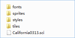
Figure: Vector tile directory structure
Related Topics
Common questions about map tile production