


Drawing A North Arrow
Feature Description
A north arrow is used to indicate north on a map, calibrating the map's orientation. It is an indispensable element in a map. When we need to add a north arrow to the map in the current layout, we can achieve this by drawing a north arrow.
Function Entry
- Features Tab->Objects Group->North Arrow.
Operation Steps
- Select a map in the layout that requires a north arrow.
- Click the North Arrow button in the Features Tab->Objects Group.
- At the location in the layout where you want to draw the north arrow, click and drag the mouse to draw the north arrow for the selected map based on its properties.
- Modify the properties of the north arrow. Double-click the north arrow whose properties need to be modified, or right-click and select the properties item of the north arrow to open the Layout Object Properties panel. In the panel, you can view or customize the general properties of the north arrow and Geo. The parameters of the basic tab are described as follows:
- Map name: Displays the name of the map associated with the current north arrow.
- Standard: By default, the selected north arrow is Eight-direction north arrow in the standard style. Nine types of selectable north arrows are provided, and you can freely switch between style options.
- Custom Picture: If the selectable north arrows provided by the system do not meet cartographic requirements, you can import a picture as the north arrow for the current associated map. The formats for importing pictures can be: *.bmp, *.jpg, *.png, *.gif.
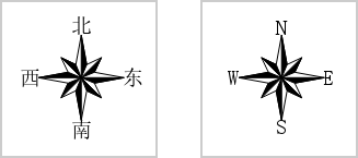
- Label Language: The labels refer to the text labels on the north arrow, providing two languages: Chinese and English. The style of the eight-direction north arrow under different language parameters is as follows (left is Chinese, right is English):
- Rotate: The numeric display box to the right of this label is used to set the rotation angle of the north arrow. The rotation angle is positive counterclockwise, with a range from -360° to 360°, and the unit is 0.1 degrees.
- Bounds: This area displays the coverage range of the current north arrow's bounds. The text boxes to the right of the 'Top', 'Bottom', 'Left', and 'Right' labels are only for displaying the range values of the north arrow's bounds and cannot be set. When the position or size of the north arrow changes, the values in these text boxes also change accordingly.
 Notes:
- The precondition for drawing a north arrow is that there is a map already drawn in the current layout, and this map is selected and not locked.
- The process of drawing a north arrow is consistent with drawing geometry.
Related Topics