


Feature Description
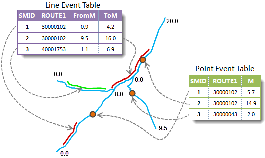
An event table records attributes of point or line events along routes, including route ID, measure values, and event descriptions such as weather conditions, driver's blood alcohol content, vehicle speed, road width, and pavement materials during traffic accidents. The Generate Spatial Data function locates these events from the event table in spatial context based on the route dataset, producing corresponding point or line data (route data) to help analysts comprehensively understand such events.
This function involves three components: route dataset, event table, and spatial data. The application establishes and maintains dynamic relationships among them. Since an event table can only have a one-to-one relationship with spatial data, ensure the event table has no existing dynamic relationships before generating spatial data. If the event table is already part of a dynamic relationship, delete that relationship first.
 |
For details about dynamic segmentation relationships, see Dynamic Segmentation Relationship Management Overview.
Feature Entry
- On the Transport Analysis Tab -> Dynamic Segmentation group, click the Dynamic Segmentation button, then select Generate Spatial Data from the dropdown menu.
- Toolbox -> Transport Analysis -> Dynamic Segmentation tools: Generate Spatial Data; or drag this tool to the Model Builder window and double-click its icon.
Parameter Description
Configure the event table and route data datasource for spatial data generation. Note: The event table and route data must reside in the same datasource.
Measure Offset Field
Errors Field
The errors field is added to the original event table (point/line) to describe issues preventing data generation. For error codes, see Errors Field Introduction.
- Event Table Data: Configure parameters for the event table, including event type, route ID field, measure field, measure offset field, and errors field. Note: Only one measure field is required for point events.
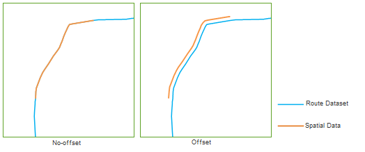
- This field specifies an offset value to shift generated spatial data (points or lines) along the route.
- The offset direction and sign depend on the route's orientation. Positive values shift data to the route's left side; negative values shift to the right. The application projects the offset onto X and Y axes and moves the data accordingly. The diagram below compares results with and without offset.
- Route direction follows node sequence from smaller to larger IDs. The left side refers to the direction's left-hand side.
- Route Data: Configure route data parameters, including datasource, route dataset, and route ID field.
- Result Data: Configure output parameters, including the name of generated spatial data.
- Click Execute to run the operation.
 Notes
Notes
If spatial data generated from an event table already exists in the current datasource, you must delete the existing spatial data through the Relationship Management window before regenerating new data.