


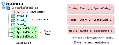
Generating spatial data involves three components: route dataset, event table, and spatial data. When generating spatial data, the application automatically establishes and stores dynamic segmentation relationships among them, which map the corresponding relationships through route IDs and measure fields. Dynamic segmentation mainly enables linked modifications between these three components. Note that all three datasets must reside in the same datasource.
 |
Once dynamic segmentation relationships are established, they require dynamic management based on the associations between event tables, route data, and spatial data. Additionally, modifying one dataset (e.g., event table) will trigger corresponding changes in others (e.g., spatial data).
1. Dynamic Segmentation Relationship Management
2. Dynamic Segmentation Relationship Linkage
Dynamic Segmentation Relationship Management
In dynamic segmentation relationships: a route dataset has a one-to-many relationship with event tables; a route dataset has a one-to-many relationship with spatial data; and an event table has a one-to-one relationship with spatial data. As shown in the left figure below: In the LinearReferencing datasource, dataset Route serves as the route dataset. SpatialData_1, SpatialData_2, and SpatialData_3 are spatial data generated from event tables Event_1, Event_2, Event_3 and Route, respectively. Thus, three dynamic segmentation relationships exist in this datasource. This means a route dataset can be shared by multiple event tables to generate multiple spatial data, but an event table can only correspond to one spatial data.
 |
Dynamic Segmentation Relationship Linkage
After generating spatial data, dynamic segmentation relationships are established among the route dataset, event table, and generated spatial data. These relationships enable automatic synchronization when modifying any component, a key feature called linkage modification in SuperMap.
Currently, SuperMap applications support the following linkage types:
Modifying event locations involves changing measure values in event tables or spatial data. Adjusting measure values in an event table updates both geometry and attribute fields in corresponding spatial data. Conversely, altering measure values in spatial data updates both geometry and the associated event table. For line events, modifying start/end measures may change event length and position. As shown below, after modifying the first event's measures from (20.78,79.37) to (150.00,180.00) in the event table, the corresponding spatial data automatically updates.
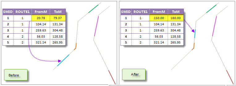 |
| Figure: Modifying measure values in event table |
Note: If modified measures fall outside the route's M-value range (e.g., changing to 26-60 for a route with M-range 3-20), spatial data geometry remains unchanged. If partial measures remain valid, spatial data will only reflect the overlapping portion.
- Event attribute changes. Linkage occurs between event tables and spatial data.
Modifying event attributes refers to editing general property fields (excluding route ID and measure fields). For example, highway speed limits may be temporarily adjusted due to weather or construction. Changes to attributes in the event table automatically update corresponding attributes in the spatial data. Similarly, modifying general attributes in spatial data will dynamically update the event table.
- Event location changes on routes. Linkage occurs between event tables and spatial data.
- Event route changes. Spatial data updates with route dataset modifications, but route data remains unaffected by spatial data changes. Linkage occurs between event tables and spatial data.
This applies when correcting or updating event routes. Specific scenarios include:
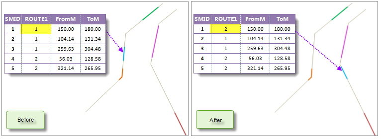
Figure: Modifying route IDs in event table Note: Modifying route IDs in route dataset attributes will not trigger updates in event tables or spatial data.
Schema changes include adding, deleting, or modifying fields. For example, adding a construction date field to a highway toll station event table will automatically replicate the change in spatial data attributes.
- Modifying linem geometry updates corresponding spatial data geometry. For example, pipeline rerouting after maintenance requires updating both geometry and measures. Spatial data objects will reposition accordingly.
- Changing a route ID in an event table updates both geometry and route ID fields in spatial data. As shown below, changing the first event's route ID from 1 to 2 relocates its spatial data to route 2.
- Event table schema changes. Spatial data attributes synchronize accordingly.
 Notes
Notes
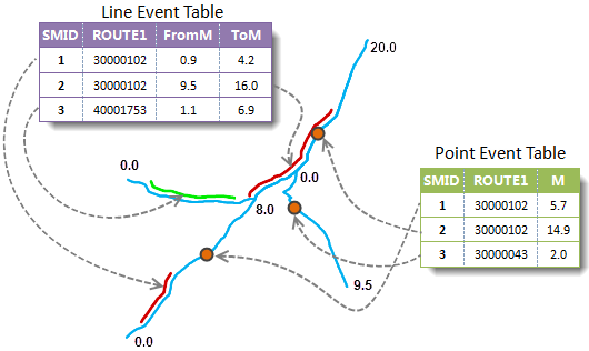
- Event tables must contain route ID and measure fields (point events require measure fields; line events require start/end measure fields). These fields ensure correct spatial positioning. All event attributes are preserved in spatial data.
- Spatial data includes an "Event_SMID" field mapping to event table SMIDs. Do not modify this field to avoid linkage errors.
- An event table with existing dynamic segmentation relationships cannot generate new spatial data until existing relationships are removed.
- Deleting datasets with dynamic segmentation relationships requires confirmation. Selecting "Yes" removes relationships and deletes the dataset; "No" cancels the operation.