


Centerline From Polygon
Feature Description
The Centerline from Polygon function extracts centerlines from all polygon objects in a dataset and saves the results as a line dataset, typically used for extracting road centerlines.
Feature Entry
- Data Tab->Data Processing->Vector->Centerline from Polygon.
- Toolbox->Data Processing->Vector->Centerline from Polygon.
Parameter Description
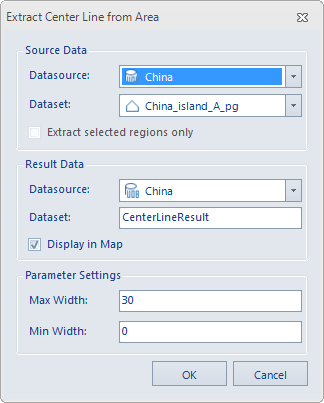
Set the following parameters in the Centerline from Polygon dialog:
- Source Dataset: Select the datasource and region dataset for centerline extraction.
- Result Data: Specify the output datasource and dataset name. The default result dataset is named "result_RegionToCenterLine".
-
Set maximum and minimum widths under Parameters:
- Maximum Width: The maximum width between polygon boundaries (greater than 0) for centerline extraction. When boundary spacing exceeds this value, boundaries will be extracted instead. Default is 30 (same unit as source dataset). Maximum width must exceed minimum width. Users can measure polygon widths using the right-side button. Recommended to set slightly larger than actual measurements for more accurate results.
- Minimum Width: The minimum width between polygon boundaries (≥0) for centerline extraction. Areas narrower than this value will not generate centerlines. Default is 0 (same unit as source dataset). Minimum width must be less than maximum width.
 Tip:
Tip:Centerlines are extracted when polygon widths fall between maximum and minimum values. No centerlines are generated below minimum width, while boundaries are extracted when exceeding maximum width.
After configuring parameters, execute the operation. The result (shown below) retains source polygon attributes in the output dataset's attribute table for comparison.
 Notes:
- Accurate maximum/minimum width settings are crucial for result precision.
- Complex intersections (e.g., overpasses, 5-way/6-way junctions) may yield suboptimal results.
Related Topics
Extract Main Lines from Polygons