



The establishment of a geodetic coordinate system in any country (or region) is a historical development process. In different periods, the reference spheroid and positioning methods used are not the same, and they are gradually improved and refined. Geodetic coordinate systems established using different reference ellipsoids and positioning are different parametric space rectangular coordinate systems, and are also inconsistent with the globally unified geocentric space rectangular coordinate system with the Earth's center as the origin. Therefore, there exists the problem of mutual conversion between different geodetic coordinate systems.
 |
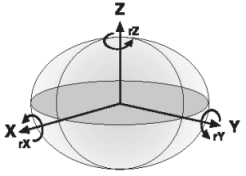 |
| Figure 1: Three-parameter method | Figure 2: Seven-parameter method |
When performing data source projection or point coordinate transformation, you can see from the dialog box that the system provides twelve projection transformation methods, namely Geocentric Translation (3-para), Molodensky (3-para), Molodensky Abridged (3-para), Position Vector (7-para), Coordinate Frame (7-para), Coordinate Frame (7-para)_new, Bursa-Wolf (7-para), Molodensky Badekas (10-para), China_3D_7P (7-para), China_2D_7P (7-para), China_2D_4P (4-para), and PROJ4 Transmethod.
| Projection Conversion Method | |
| Name | Descriptions |
| GeocentricTranslation | Geocentric translation method based on three parameters. |
| Molodensky | Molodensky transformation method. |
| MolodenskyAbridged | Simplified Molodensky transformation method. |
| PositionVector | Position Vector method. |
| CoordinateFrame | Geocentric seven-parameter transformation method. |
| BursaWolf | Bursa-Wolf method. |
| MolodenskyBadekas | Molodensky-Badekas projection conversion method, a ten-parameter spatial coordinate transformation model. |
| China_3D_7P | Three-dimensional seven-parameter transformation model, suitable for control point coordinate transformation between geodetic coordinate systems under different earth ellipsoid datums at the national and provincial ellipsoid surfaces of 3 degrees or more. The model involves three translation parameters, three rotation parameters, and one scale change parameter, and also needs to consider the differences in semi-major axis and flattening of the two earth ellipsoids corresponding to the two geodetic coordinate systems. |
| China_2D_7P | China_2D_7P two-dimensional seven-parameter transformation model, applicable for control point coordinate transformation between geodetic coordinate systems under different earth ellipsoid datums at the national and provincial levels for ellipsoid surfaces of 3 degrees or more. The model involves three translation parameters, three rotation parameters, and one scale change parameter. For the conversion from the 1954 Beijing Coordinate System and the 1980 Xi'an Coordinate System to the 2000 National Geodetic Coordinate System, due to the low accuracy of geodetic heights under the two parametric systems, it is recommended to use the two-dimensional seven-parameter transformation. |
| China_2D_4P | Two-dimensional four-parameter transformation model, suitable for control point coordinate transformation within a local range of up to 2 degrees at provincial and lower levels. The model involves three translation parameters and one scale change parameter. |
| PROJ4 Transmethod | PROJ4 Transmethod projection algorithm, which is based on the PROJ4 third-party projection tool, thereby supporting more projection operations and meeting the data projection needs of more overseas users. This projection algorithm only supports conversion between projections with corresponding EPSG codes. |
| WGS 1984 to GCJ-02 | Used to convert the WGS 1984 coordinate system to the GCJ-02 coordinate system. This method is provided by default and supports dynamic map projection and data projection transformation, including coordinate transformation for terrain raster data. It is available only when the source coordinate system is WGS 1984 and the target coordinate system is WGS_1984/Web_Mercator. Supported in SuperMap iDesktopX 2026 and later. |
The above conversion methods are commonly divided into three-parameter conversion methods and seven-parameter conversion methods:
- Three-parameter conversion method
When converting reference systems, a relatively simple conversion method is the so-called three-parameter conversion method. The mathematical model on which this transformation method is based assumes that the two geodetic reference systems are only translated in space coordinate origins, without considering other factors (see Figure 1). This method inevitably produces three parameters: the translation amounts in the X, Y, and Z directions. The three-parameter conversion method is simple to calculate but has low accuracy and is generally used for conversion between different geocentric space rectangular coordinate systems.
- Seven-parameter conversion method
The mathematical model of the seven-parameter method not only considers the translation of the coordinate system but also factors such as coordinate system rotation and scale differences. Therefore, in addition to three translation parameters, three rotation parameters (also called three Euler angles) and a scale factor are required. The conversion principle is shown in Figure 2. The three translation parameters are represented by ΔX, ΔY, ΔZ; the three rotation parameters are represented by Rx, Ry, Rz; and the scale factor is represented by S. Here, the scale factor represents the scaling amount from the original coordinate system to the new coordinate system. Generally, the unit of translation parameters is meters (consistent with the unit), the unit of rotation parameters is seconds, and the unit of scale factor is parts per million.
-
Geocentric Translation, Molodensky, and Simplified Molodensky (MolodenskyAbridged) transformation methods are projection conversion methods with relatively low accuracy. The three-parameter conversion method requires three translation parameters (ΔX, ΔY, ΔZ), and both the Molodensky and Simplified Molodensky methods also require three translation parameters (ΔX, ΔY, ΔZ). These methods are generally used when data accuracy requirements are not high.
- Position Vector, Coordinate Frame (Geocentric seven-parameter transformation), and Bursa-Wolf method are conversion methods with relatively high accuracy. They require seven parameters for adjustment and conversion, including three translation parameters (ΔX, ΔY, ΔZ), three rotation parameters (Rx, Ry, Rz), and one scale parameter (S). These methods are exactly the same, but differ in customary names due to different countries, regions, or survey schools.
 Tip:
Tip:In actual work, which conversion method to adopt depends on the specific situation. The satisfaction of conversion results depends on the setting of transformation parameters. Transformation parameters can be obtained from official surveying agencies or data providers; they can also be measured and calculated by yourself. Whether the transformation parameters are appropriate must be determined through control points that exist in both reference systems.
Related Topics