


Feature Description
The Regional Aggregation Map aggregates point datasets within an area based on the selected Aggregation Group Fields. The aggregation size does not change with map zooming.
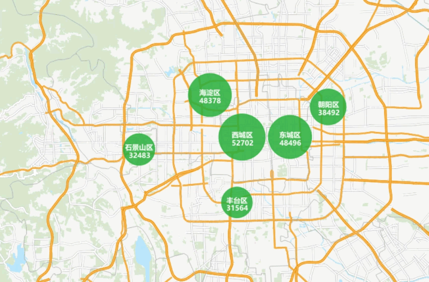
The Regional Aggregation Map is suitable for expressing the distribution of housing prices, GDP, etc., across cities in a region.
Function Entry
- Thematic Map tab -> Aggregation Map group -> Regional Aggregation Map.
- Layer Manager -> Layer context menu -> Create Thematic Map ... -> Aggregation Map -> Regional Aggregation Map.
Parameter Description
The parameters for the Regional Aggregation Map are in the Layer Properties panel. A detailed description of the parameters is as follows:
- For settings in the Display Control group and the Change Dataset group, please refer to Setting Layer Common Properties.
- The parameters group description is as follows:
- Aggregation Group Field: Used to set the field for defining aggregation areas, such as town, province, city, etc. To use a mathematical expression of a property field as the group field, select the "Expression..." item from the combo box dropdown list and construct the mathematical expression for the property field in the pop-up "SQL Expression" dialog.
- Aggregation Field: Used to set the field for aggregation, its type must be numeric. If you only need to represent the aggregation of point objects, setting an aggregation field is not required. For example, to express the average house price in an area, select the house price field as the aggregation field and choose Average in the Aggregate method. If you only need to express how many houses are in the area, you do not need to set an aggregation field; the default is to count the number of points in the area.
 Tip:
Tip:Fields in the Aggregation Group Field and Aggregation Field dropdown lists are displayed by default as Field Alias. If needed, you can switch to display the field name in the File tab -> Options group. For details, please refer to the Preference Settings document.
- Aggregate: After setting the aggregation radius, you need to set the resampling method for the aggregation radius via the Aggregate option. Five methods are provided: Average, Count, Maximum, Minimum, and Sum.
- Show Labels: Used to set whether to display labels for the aggregation map. Configurable parameters are as follows:
- Text Style: Sets the label style, including font, font size, tilt angle, text color, outline color, shadow color, and font effect. Font effects include bold, strikethrough, italic, underline, shadow, transparent background, outline, and outline pixel size.
- Label Expression: Used to set the label expression style for aggregation. The ... button on the right provides the SQL Expression dialog. The dialog description is as follows:
- Field List: Displays the two fields used to create the Regional Aggregation Map. Double-click a field row to add it to the expression input box.
- String: Provides functions for character manipulation of combined fields. For a detailed explanation, please refer to the String table on the Building SQL Query Function Description page.
- Aggregate: Provides functions for calculation and processing of the aggregation field. For a detailed explanation, please refer to the Aggregate table on the Building SQL Query Function Description page.
- Operator: Provides two operators: "||" and "\n", representing concatenation and newline display respectively.
- Expression Dialog: Displays the entered expression. When you need to add characters other than fields, you can manually input the expression. Strings should be enclosed in English single quotes.
- Preview: The preview area can display the effect of the input expression in real time.
- Display Precision: Used to set the display precision for aggregation labels. When an aggregation field is selected and an aggregate method is set, the label content may contain decimal points. Use display precision to set the number of decimal places to show.
- Line Spacing: Used to adjust the spacing between lines in a label. When a label contains multiple lines of text, you can control the distance between text lines by setting the line spacing.
- Marker Style: Used to set the marker style for the aggregation symbol. Configurable parameters are as follows:
- Point Symbol: You can select the type of point symbol via the marker symbol selector.
- Maximum/Minimum Symbol Size: Used to set the maximum and minimum display sizes for the aggregation symbol.
- Color Scheme: Used to set the color of the aggregation symbols. You can choose from the dropdown button to the right of the color ramp, or set it via the custom button on the far right of the color scheme.
- Minimum/Maximum Color Transparency: Used to set the transparency for the colors at both ends of the color ramp.
Below is an example of a Regional Aggregation Map showing housing prices in a city. For detailed mapping steps, please refer to Regional Aggregation Map Application Example.
Related Topics