


Feature Description
The Dynamic Aggregation Map represents feature information on the map using an aggregation method, where clusters are drawn at the locations of the features. It is primarily used to express the distribution of resources such as education and healthcare in a region, providing data references for relevant departments to rationally plan resources.
When the map scale is zoomed in to the point where only one feature is within the aggregation radius, continuing to zoom in will not change the aggregation effect.
When the map scale is zoomed out to the point where the aggregation radius encompasses all aggregated features, continuing to zoom out will also not change the aggregation effect.
Applicable Data: Point dataset.
Application Scenarios
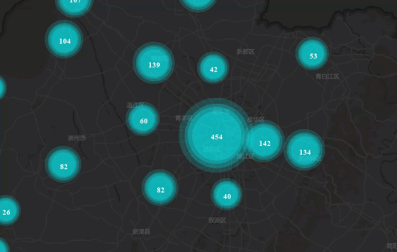
- Distribution Of Educational Resources: In economically developed and densely populated areas, educational resources are also very concentrated. When using conventional cartography, data occlusion may occur, making it impossible to directly obtain the quantity of educational resources from the map. In such cases, a Dynamic Aggregation Map is needed to dynamically express the distribution of educational resources in the area from a quantitative perspective at different scales.
Functional Entry
- Thematic Map Tab -> Aggregation Map Group -> Dynamic Aggregation Map.
- Layer Manager -> Layer Context Menu -> Create Thematic Map ... -> Aggregation Map -> Dynamic Aggregation Map.
Parameter Description
The parameters for the Dynamic Aggregation Map are located in the Layer Properties panel. The detailed parameter descriptions are as follows:
The following shows the effect of a Dynamic Aggregation Map for educational resources in a city. For detailed steps on how to create it, please refer to the Dynamic Aggregation Map Application Example.
- For settings of the Display Control group and the Change Dataset group, please refer to Setting Layer Common Properties.
- The description of the Parameters group is as follows:
- Aggregation Radius: Used to control the variation in cluster quantity and size. The default setting is 20.
- Aggregation Field: Used to set the field for aggregation; the type must be numeric. If you only need to represent the aggregation of point objects, there is no need to set an aggregation field. The fields in the dropdown list are displayed by default as Field Aliases. If needed, you can switch to display field names in the File Tab -> Options group. For details, please refer to the Preferences document.
- Display Precision: Used to set the display precision for cluster labels. After selecting an Aggregation Radius and setting an Aggregate method, the label content may contain decimal points. The Display Precision setting controls the number of decimal places shown in the labels.
- Aggregate: After setting the Aggregation Radius, you need to use the Aggregate setting to define the resampling method for the aggregation radius. Five resampling methods are provided here: Average, Count, Maximum, Minimum, and Sum.
- Show Labels: Used to set the style of the labels. You can configure the font, font size, italic angle, text color, outline color, shadow color, and font effect. Font effects include bold, strikethrough, italic, underline, shadow, transparent background, outline, and outline pixel size.
- Marker Style: Used to set the marker style for the aggregation symbols. You can select the type of point symbol via the marker symbol selector and also support setting the maximum and minimum marker sizes.