


"Advanced" Tab
Used for advanced settings of individual values in the current unique value thematic map. All settings in this tab will be reflected in real-time on the current unique value thematic map, achieving WYSIWYG (What You See Is What You Get).
- "Offset Settings" Section: This section configures offset values for point, line, and area objects in unique value thematic maps.
- Offset Unit: Specifies the unit for offset values. Click the drop-down button to select between "unit" and "0.1mm". "0.1mm" indicates offset values are measured in 0.1mm units; "unit" maintains consistency with the coordinate system's units.
- Offset X: Sets the horizontal offset of labels relative to their represented objects. Values can be directly entered or derived from numeric fields in the layer.
- Offset Y: Sets the vertical offset of label symbols relative to their represented objects. Values can be directly entered or derived from numeric fields in the layer.
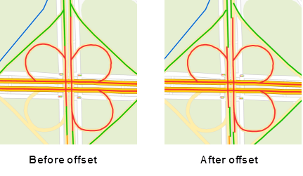
- "Traffic Situation" Section: Configures road grading and road offset for Traffic Condition Maps at small scales.
- Road Grading: Controls road display: 0 hides road conditions (e.g., minor roads at small scales); 1 displays single-line roads (e.g., ramps); 2 displays dual-line roads (e.g., highways).
- Road Offset: Sets offset distance for dual-line roads in traffic condition maps. Positive values shift leftward along line direction, negative values shift rightward (unit: 0.1mm). Enables clear dual-line road display at small scales.
 Notes:
Line direction refers to the drawing direction. For a line drawn left-to-right, the left side is above the line and the right side is below.
Notes
- Applying thematic layer offset settings can create shadow effects in 2D maps for enhanced cartographic results.
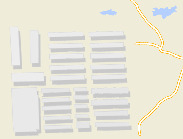
Figure: Thematic Map Shadow Effect - Offset settings are currently unavailable for thematic maps created with 3D point, line, or area layers.
 Related Topics
 Modify Unique Value Thematic Map