


Feature Description
This function is used to export point, line, region, text dataset, and attribute tables to the China Standard Vector Exchange Format — VCT file.
The Ministry of Land and Resources formulated the land use data exchange format based on the national standard "Geographic Spatial Data Exchange Format" (GB/T17798-2007). Land use data only describes vector data, and the file extension is VCT, referred to as VCT file. Through this file, various types of land and resources geographic data exchanges are realized. The VCT vector data exchange format is widely used in the land and resources sector for the submission of land use survey results, land use planning results, and cadastral survey database exchanges. For specific descriptions of VCT parameters, please refer to the VCT File page.
- Supports exporting to three versions of VCT data: cnsdtf_vct 1.0 (referred to as VCT1.0), landuse_vct 2.0 (referred to as VCT2.0), and landuse_vct 3.0 (referred to as VCT3.0).
- Supports exporting multiple datasets into one VCT file.
- Supports exporting to VCT file by importing an existing .xml file that configures layer types.
Function Entry
- Click the Start tab -> Data Processing -> Data Export button;
- In the workspace manager -> Datasource or Dataset context menu -> Export Dataset option.
- Toolbox -> Data Export -> Export Vector -> Export to VCT.
Operation Steps
- In the Data Export dialog, select China Standard Vector Exchange Format from the Export Type dropdown for the dataset to be exported. The right area of the dialog displays the parameters that need to be set for exporting the VCT file, as shown in the figure below.
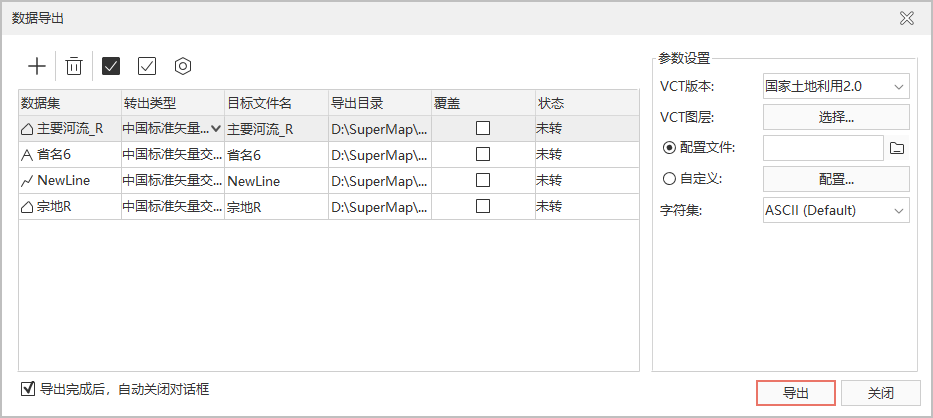
- Set VCT Version: Select the VCT export version. The application provides cnsdtf_vct 1.0, landuse_vct 2.0, and landuse_vct 3.0 versions for users to choose from.
- Config VCT Layer: Different VCT versions require slightly different parameter configurations:
- Select export dataset: Click the Select button to pop up the Select Dataset dialog. Use the Add button on the toolbar to load multiple datasets under this datasource. Supports selecting multiple dataset files to export to one VCT file.
- VCT layers can be configured in two ways: by importing a Config File or by Custom configuration:
- Import configuration file: Import an existing config file to configure the export dataset.
 Note:
Note:When using a config file in Linux/Arm operating systems, the encoding of the config file needs to be converted to UTF-8 first.
- Custom configuration: Click the Configure button to pop up the Configure VCT Layer dialog. The information that needs to be configured varies depending on the selected VCT export version, which is described separately below.
- Import configuration file: Import an existing config file to configure the export dataset.
- When the selected export version is CNSDTF_VCT 1.0, the Configure VCT Layer (1.0) dialog pops up:
- Dataset and Datasource display the layer name of the export dataset and its belonging datasource.
- VCT Type: Set the VCT Type after the export dataset is converted. Currently, the application presets 47 types of VCT export types, such as boundary points, measurement control points, administrative regions, etc. Users can click the VCT Type dropdown button to select the converted type for each dataset.
If the preset fields do not meet your export type requirements, you can set the layer config file yourself. The layer type config file is stored in: Installation path: Templates\Conversion folder, in the vctDataType.xml file.
- Layer type configuration:
- Open the layer config file vctDataType.xml, as shown in the figure below: A layer type consists of three parts: FeatureID (feature code), LayerName (feature name), TabularName (attribute table name). For example: the feature code of the boundary point layer is 2006030100, the boundary point is the feature name, and the attribute table name is JZD.
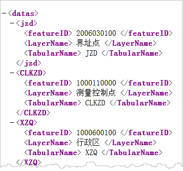
You can configure the layer type file according to the above rules, save the modified file, and restart idesktopx. Then you can select the newly added layer type under VCT Type.
- Open the layer config file vctDataType.xml, as shown in the figure below: A layer type consists of three parts: FeatureID (feature code), LayerName (feature name), TabularName (attribute table name). For example: the feature code of the boundary point layer is 2006030100, the boundary point is the feature name, and the attribute table name is JZD.
- Layer type configuration:
- VCT Field: After the VCT Type is set, double-click the VCT Field text box of the dataset to pop up the Select Field dialog. Set the export fields, select the fields in the dataset that need to be exported, check the checkbox in front of the corresponding field, and modify the type, length, and precision.
- VCT Field Name: The field after dataset conversion.
- VCT type: Click the VCT type of this field, and you can select from five types in the dropdown menu: Char, Integer, Float, Data, Time, Varbin.
- VCT field length: Set the field length of the selected type. The length of the VCT field is not defined when the current setting is 0 or empty.
- VCT Field Precision: Set the field precision of the selected type. The precision of the VCT field is not defined when the current setting is 0 or empty.
- When the selected export version is LANDUSE_VCT 2.0, the Configure VCT Layer (2.0) dialog pops up. The settings for VCT Type and VCT Field are the same as those for National Natural Resources 1.0. This version supports setting topology for region layers:
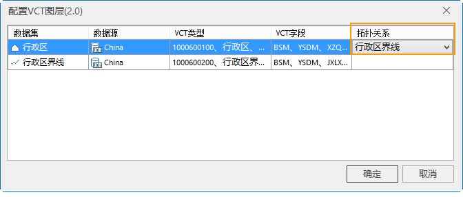
- Topology: Configure the line dataset that has topology with the exported region dataset. If a topology between a specific region dataset and a line dataset is specified here, both the line dataset and the region dataset must be exported to this VCT file. For example, if a topology is established between the region dataset Administrative Region and the line dataset Administrative Boundaries Annotation, the exported VCT file must contain the datasets Administrative Region and Administrative Boundaries Annotation.
- In the VCT file obtained after establishing topology, the series line IDs obtained by splitting the Administrative Region are stored in the VCT's LineBegin/LineEnd. The feature code corresponding to the line ID uses the line's feature code.
- In the VCT file obtained without establishing topology, the series line IDs obtained by splitting the Administrative Region are stored in the VCT's LineBegin/LineEnd. The feature code corresponding to the line ID uses the region's feature code.
- Topology: Configure the line dataset that has topology with the exported region dataset. If a topology between a specific region dataset and a line dataset is specified here, both the line dataset and the region dataset must be exported to this VCT file. For example, if a topology is established between the region dataset Administrative Region and the line dataset Administrative Boundaries Annotation, the exported VCT file must contain the datasets Administrative Region and Administrative Boundaries Annotation.
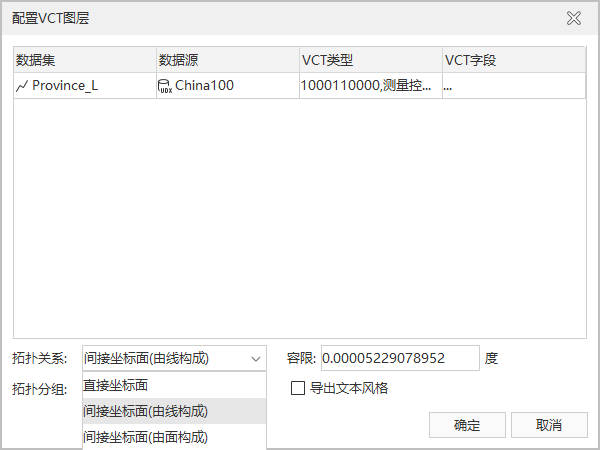
- When the selected export version is LANDUSE_VCT 3.0, the Configure VCT Layer (3.0) dialog pops up. The settings for VCT Type and VCT Field are the same as those for National Natural Resources 1.0. This version supports selecting and setting topology, which includes: direct coordinate plane, indirect coordinate plane (composed of lines), indirect coordinate plane (composed of regions) for users to choose from.
- Charset: The character encoding type used by the export dataset. To ensure the dataset is displayed correctly, a suitable character set needs to be used. By default, ASCII (Default) character set is used during export. The most commonly used ASCII character set is mostly used to display Roman numerals and letters, utf-8 is used to display simplified Chinese characters, and to meet the needs of cross-language and cross-platform computer display, the Unicode character set is used. For the list of character sets supported by the application, please refer to Character Set List.
- Set the VCT Type and VCT Field of the exported data in sequence. After the settings are completed, click the OK button to exit the current dataset settings window. Click the Export button in the data export dialog to perform the operation of exporting the VCT file.
Related Topics