


Data Export
Feature Description
The Data Export function is used to export data from SuperMap iDesktopX into commonly used formats, including ArcGIS formats, CAD formats, MapInfo formats, FileGDB formats, Telecom formats, and 20 other common data formats, for use in related third-party software to achieve seamless data sharing and collaboration.
For the supported export formats, please check the Formats Supported for Data Import and Export page.
Function Entrances
- Start tab -> Data Processing drop-down menu -> Data Export.
- Workspace Manager -> Context menu of a dataset or datasource -> Export Dataset.
Operating Steps
- Click the Start tab -> Data Processing drop-down menu -> Data Export button. The Data Export dialog box will pop up.
- Click the Add button on the toolbar, or double-click the Dataset cell in the list box. The Select dialog box pops up, listing all datasources in the current workspace on the left side, and listing the names and types of all datasets in the selected datasource on the right side. Users can select one or multiple datasets and click the OK button to add the files that need to be exported from the current workspace to the data list.
- All added data will be displayed in the list box on the left side of the Data Export dialog box. Users can use the toolbar above the list box to add, remove datasets, or uniformly modify the properties of exported datasets. The description of the list box is as follows:
- Dataset: Displays the names of the datasets to be exported.
- Export Type: The system will automatically recognize the export format based on the selected dataset type. You can also click the drop-down button for the Export Type item and select other data formats from the drop-down list.
- Result File: The name of the exported file. It defaults to the same as the dataset name. Users can also rename the export file by double-clicking this column: select the dataset to be renamed, click the Result File item or press the F2 key, the result file becomes editable, and then you can input a new file name as the name after export.
- Export Path: This item shows the default path for data export. Users can also change the export path for a dataset: select the dataset for which you want to modify the export path, double-click the Export Path item, and then change the dataset's export path in the popped-up Browse Folder window. Note: If the export path does not exist, the program will automatically create the destination folder.
- Overwrite: This checkbox is used to set whether to overwrite or not overwrite existing files with the same name under the export path. If this checkbox is checked, existing files with the same name will be overwritten; if not checked, the file will not be exported.
- State: Before data is exported, the State item displays as Unconverted; if the data is successfully exported, it displays as Succeed; if the data fails to export, it displays as Failed.
- Users can select one or multiple files in the list box and set various parameters for the exported data in the parameters area on the right side of the Data Export dialog box. The parameter items that can be set in the right parameters area differ depending on the selected export data format:
- Export Vector Data: Including exporting to vector data such as SHP, CSV, DWG, Excel, etc. The parameters that need to be set are as follows (the parameters available for different vector data exports may differ, subject to actual operation):
- Export Point as WKT: Available only when exporting to CSV. This checkbox is used to show or set whether to export points as WKT fields.
- Export Header: Available only when exporting to CSV. This checkbox is used to show or set whether to export the header information of the file.
- Export Extended Field: Available only when exporting to AutoCAD files. This checkbox is used to show or set whether to export the extended fields of AutoCAD files.
- Export Extension Records: Available only when exporting to AutoCAD files. This checkbox is used to show or set whether to export the extension records of AutoCAD files.
- Export Borders: Available only when exporting to AutoCAD files. This checkbox is used to show or set whether to export the border data of AutoCAD files.
- Export Line Width: Available only when exporting to AutoCAD files. This checkbox is used to show or set whether to export the polyline width data in AutoCAD files.
- Object Color by Layer: Available only when exporting AutoCAD files. If selected, the color properties of all objects after export will be uniformly set to 'by layer', and all objects in the same layer will have consistent colors. If objects in the same layer originally had different colors, after export, the color for that layer will be consistent with the color of the first object in the original layer. If not selected, the exported object colors will follow the colors configured in the current desktop map.
- Text field length is consistent with source data: Available only when exporting ArcGIS Shapefile files. This checkbox is used to set the text field length for the exported ArcGIS Shapefile files. If selected, the exported text field length will be consistent with the source data. If the field value exceeds the length limit, the excess part will be automatically truncated. If not selected, the field length after export will be automatically adjusted based on the actual maximum length of all field values. This is the default option.
- CAD Version: Available only when exporting to AutoCAD files. The drop-down list to the right of this label allows you to select the version number for the exported AutoCAD DWG File (*.dwg) or AutoCAD DXF File (*.dxf). Currently, AutoCAD R12, AutoCAD R13, AutoCAD R14, AutoCAD 2000, AutoCAD 2004, and AutoCAD 2007 are provided. The default export version is AutoCAD 2013.
- Style Mapping File: Available only when exporting to AutoCAD files. You can choose whether to export a style mapping file. For a description of the style mapping file, please refer to the relevant description in Import CAD Data.
- Charset: The character encoding type used for the exported dataset. To ensure the dataset displays correctly, a suitable character set must be used. During export, ASCII (Default) is used by default. The most commonly used ASCII character set is primarily for displaying Roman numerals and letters, UTF-8 is used for displaying simplified Chinese characters, and the Unicode character set is used to meet the needs of cross-language, cross-platform computer display. For the list of character sets supported by the application, please see Character Set List.
- Filter Expression: You can filter out objects that do not need to be exported by setting a filter expression, so that only objects satisfying the conditions participate in the export. For how to use SQL Expressions, please refer to SQL Expression.
- Export China Standard Vector Exchange Format:
- VCT Version: Select the VCT export version, providing three options: cnsdtf_vct 1.0, landuse_vct 2.0, and landuse_vct 3.0.
- VCT Layer: Select a dataset as the VCT layer. Two methods, Config File and Custom, are provided to configure the VCT layer:
- Config File: Import an existing configuration file to configure the exported dataset.
- Custom: The configuration parameters provided differ for different VCT versions. For details, please refer to the relevant description in Export VCT Data.
- Charset: The character encoding type used for the exported dataset. To ensure the dataset displays correctly, a suitable character set must be used. During export, ASCII (Default) is used by default. The most commonly used ASCII character set is primarily for displaying Roman numerals and letters, UTF-8 is used for displaying simplified Chinese characters, and the Unicode character set is used to meet the needs of cross-language, cross-platform computer display. For the list of character sets supported by the application, please see Character Set List.
- Export Telecom Files:
- Dataset List: Select the corresponding type(s) of dataset(s) based on the telecom file type (point, line, polygon) to export. Multiple selections are allowed.
- Field: Available only when exporting to Telecom Vector Text.
- Charset: The character encoding type used for the exported dataset. To ensure the dataset displays correctly, a suitable character set must be used. During export, ASCII (Default) is used by default. The most commonly used ASCII character set is primarily for displaying Roman numerals and letters, UTF-8 is used for displaying simplified Chinese characters, and the Unicode character set is used to meet the needs of cross-language, cross-platform computer display. For the list of character sets supported by the application, please see Character Set List.
- Filter Expression: You can filter out objects that do not need to be exported by setting a filter expression, so that only objects satisfying the conditions participate in the export. For how to use SQL Expressions, please refer to SQL Expression.
- Export File GeoDatabase Vector Files (FileGDB):
- Dataset List: Select the dataset(s) to export. Multiple selections are allowed.
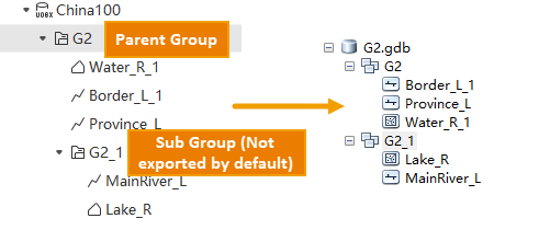
- When exporting grouped datasets, as the FileGDB data structure does not support subgroups by default, subgroups and datasets within subgroups are not exported, and only datasets under the parent group are displayed.
- If you need to export subgroups, you can use the Add button above to add datasets from the subgroup to the list. After export, the subgroups will lose their hierarchical relationship with the parent group and become parallel.
- Append: Through the append function, you can append the currently selected data for export to an existing File GDB file. You need to set the connection field for appending.
- Charset: The character encoding type used for the exported dataset. To ensure the dataset displays correctly, a suitable character set must be used. During export, ASCII (Default) is used by default. The most commonly used ASCII character set is primarily for displaying Roman numerals and letters, UTF-8 is used for displaying simplified Chinese characters, and the Unicode character set is used to meet the needs of cross-language, cross-platform computer display. For the list of character sets supported by the application, please see Character Set List.
- Retain Grouping: Provides the option to retain grouping. If this checkbox is selected, dataset groups will be retained after exporting to the File GDB file; otherwise, they will not be retained.
 Notes:
Due to restrictions such as dataset type and coordinate system under the Feature Dataset in a GDB, to ensure complete export of datasets under a dataset group, the datasets under the dataset group must meet the following conditions:
- The dataset types under the dataset group are only 2D/3D point, line, and region datasets. Tabular datasets will not remain within the group after export. Other datasets are not supported for export to FileGDB.
- All datasets under the dataset group have a consistent coordinate system. When coordinates are inconsistent, only datasets with the same coordinate system as the first dataset will be exported.
- The hierarchy of the dataset group under the current datasource has only one level besides the root group, meaning there is no nested grouping under the dataset group.
- Preserve 64-bit integer field format: Used to specify whether to preserve the 64-bit integer field format during export. If selected, the original format of long integer fields will be preserved, and the exported data needs to be used in ArcGIS Pro 3.2 or higher; if not selected, long integer fields will be exported as double-precision.
- Filter Expression: You can filter out objects that do not need to be exported by setting a filter expression, so that only objects satisfying the conditions participate in the export. For how to use SQL Expressions, please refer to SQL Expression.
- Dataset List: Select the dataset(s) to export. Multiple selections are allowed.
- Export Personal GDB Vector Files:
- Dataset List: Select the dataset(s) to export. Multiple selections are allowed.
- Filter Expression: You can filter out objects that do not need to be exported by setting a filter expression, so that only objects satisfying the conditions participate in the export. For how to use SQL Expressions, please refer to SQL Expression.
- Export GJB Files:
- Dataset List: Select the dataset(s) to export. Multiple selections are allowed.
- Charset: The character encoding type used for the exported dataset. To ensure the dataset displays correctly, a suitable character set must be used. During export, ASCII (Default) is used by default. The most commonly used ASCII character set is primarily for displaying Roman numerals and letters, UTF-8 is used for displaying simplified Chinese characters, and the Unicode character set is used to meet the needs of cross-language, cross-platform computer display. For the list of character sets supported by the application, please see Character Set List.
- Export Layer Type: The supported layer info options include Measurement Control Point, Industrial and agricultural social and cultural facilities, Residential area and ancillary facilities, Land Transportation, Pipeline, Water/Land, Seafloor Topography and Geology, Reefs/Shipwrecks/Obstacles, etc. The default is Measurement Control Point.
- Filter Expression: You can filter out objects that do not need to be exported by setting a filter expression, so that only objects satisfying the conditions participate in the export. For how to use SQL Expressions, please refer to SQL Expression.
- Export to Raster and Image Dataset:
- Compression Method: When the export type is TIFF File, you can set the compression method for the exported file. Four compression methods are provided: None, LZW, JPEG, DEFLATE.
- None: No compression.
- LZW: Lossless compression, using an advanced string table compression to significantly improve the compression efficiency of image files.
- JPEG: Lossy compression, based on the DCT discrete cosine transform compression algorithm with a high compression ratio. JPEG compression algorithm can only be used for unsigned 8-bit integer raster data (single-band or multi-band), and can be applied to the first 12 bits of bit16 data.
- DEFLATE: Lossless compression, using an algorithm that combines LZ77 with Huffman coding.
- Compression Ratio (%): This item is used to display or set the compression ratio for image files. The default compression ratio is 75%. This item is only available when the export file format is JPG File (*.jpg).
- Coordinate Reference File: Click the Select button on the right to pop up the Open dialog box, where you can set the path for the coordinate reference file of the image data for the currently selected raster dataset to be exported. This item is only available when the export file format is JPG File (*.jpg), PNG File (*.png), Bitmap File (*.bmp), or GIF File (*.gif).
- Export Affine Information as TFW File: This checkbox is used to show or set whether to export the affine transformation information (mapping between image coordinates and GCS) to an external file. This checkbox is only available when the export file format is Tiff (*.tif). It is checked by default, meaning the affine information will be exported to an external TFW file; otherwise, the projection will be exported into the Tiff file.
Notes:- When exporting an image dataset to JPG File (*.jpg), the width or height of the JPG file cannot exceed 65500 pixels. There is no such restriction when exporting to PNG File (*.png).
- Compression Method: When the export type is TIFF File, you can set the compression method for the exported file. Four compression methods are provided: None, LZW, JPEG, DEFLATE.
- Export Vector Data: Including exporting to vector data such as SHP, CSV, DWG, Excel, etc. The parameters that need to be set are as follows (the parameters available for different vector data exports may differ, subject to actual operation):
- Check the Auto close the dialog after export finishes checkbox to control whether the dialog box automatically closes when data export ends. It is checked by default.
- Click the Export button. The system will batch export all datasets in the list box. The Export Progress window will display the overall progress of exporting all data in the list box and the export progress of the currently exporting single data item.
Notes:- If all datasources in the current workspace are image data engines, the export button will be grayed out and unavailable.
- If the current workspace contains image data engines, clicking the Add button in the Data Export window will cause the image data engines to appear in the datasource list on the left side of the Select dialog box, but image datasets under that datasource cannot be added.
- Exporting datasets to KML and KMZ formats requires that they must be in the WGS_1984 geographic coordinate system, otherwise the output will fail.
- When exporting vector data to VCT files, the corresponding VCT layer type must be set, otherwise the output will fail.
- When importing and exporting telecom raster data, please note the following two points:
- Telecom raster format only supports the import and export of Grid type datasets.
- Telecom raster format only supports the import and export of raster data with a pixel bit depth of 16. When the export data is a Grid dataset with a pixel bit depth lower than 16, automatic pixel bit depth conversion will be performed, uniformly converting it to 16-bit.
- When exporting dataset attribute tables to Microsoft Excel Files, currently only exporting record sets less than or equal to 100,000 at once is supported. If the dataset record count is 0, the output will fail.
- The third-party TIF library used by currently supports a maximum data volume of 4G for exporting as TIFF images. If the data to be exported exceeds 4G, it is recommended that users export the data in chunks by clipping or export it in the form of SIT Image File (obsolete).
- Limited by third-party libraries, currently the maximum data volume supported for exporting to SHP files is 4G. If the data to be exported exceeds 4G, it is recommended that users export the data as FileGDB files.
- The field name storage for SHP files is based on the DBF specification, with a maximum allowance of 10 bytes (not character count). If a field name exceeds this limit during export, it will be automatically truncated. For example: English field name "Population2025" would be truncated to "Population"; Chinese field name "行政区名称" would be truncated to "行政区" (UTF-8, one Chinese character occupies 3 bytes). If the truncated name duplicates an existing name, a sequence number (e.g., "Populati_1", "Populati_2") will be automatically appended to avoid conflicts. Therefore, when exporting to SHP, please confirm the field name length and consider renaming fields in advance to shorten them to within 10 bytes.
Related Topics