


Feature Description
The Ministry of Land and Resources established the land use data exchange format based on the national standard "Geospatial Data Exchange Format" (GB/T17798-2007). Land use data specifically describes vector data with the file extension VCT, collectively called VCT file, which facilitates geo-data exchange for various land resources management purposes. The VCT vector data exchange format is widely used for submitting land use status survey results, land use planning achievements, and cadastral survey database exchanges within land resources departments.
A VCT file consists of eight components: 1) File header describing basic information like layer bounds, coordinate dimensions, and scale; 2) Feature type parameters defining layer components; 3) Attribute data structure specifying attribute schemas; 4) Graphic data containing geometric shapes; 5) Annotation elements with text labels; 6) Topology data for geometric relationships; 7) Attribute values; 8) Graphic presentation data.
VCT File = File Header + Feature Type Parameters + Attribute Data Structure + Graphic Data + Annotation + Topology Data + Attribute Data + Graphic Presentation Data
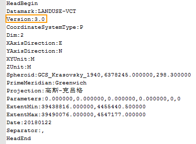
- Part 1: File Header: Begins with HeadBegin and ends with HeadEnd. The Version field indicates VCT file version (1.0, 2.0, or 3.0).
- Part 2: Feature Layer Type Parameters: Enclosed between FeatureCodeBegin and FeatureCodeEnd. All three versions support point, line, polygon, and annotation layers. VCT3.0 additionally supports attribute table configuration.
- Point/line/polygon/annotation types contain four fields: 1) Feature type code; 2) Feature type name; 3) Layer type; 4) Dataset name in SuperMap.
- Attribute tables have two fields (e.g., "ZD_QLR,ZD_QLR"): 1) Table name in TableStructure; 2) Dataset name in SuperMap.

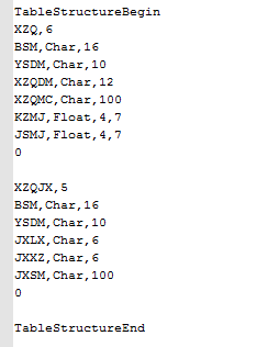
- Part 3: Attribute Data Structure: Defines attribute schemas for each layer between TableStructureBegin and TableStructureEnd. The first line specifies field count (e.g., "XZQ,6" indicates 6 fields). Subsequent lines define fields as (FieldName,Type,Width).
- Part 4: Graphic Data: Contains geometric data for features, categorized into point, line, and polygon types.
- First line: Identifier - Unique object ID code for each feature.
- Second line: Feature code - Matches predefined codes or shows "Unknow".
- Third line: Layer name - Matches predefined layers or shows "Unknow".
- Fourth line: Graphic feature type:
- Point types: 1|2|3 (Independent point, Node, Directed point).
- Line types: 1|2|3|4|5|6|100 (Polyline, Arc, Circle, Ellipse, Smooth curve, B-Spline, Indirect coordinates).
- Line graphics: Fifth line specifies vertex count followed by coordinate pairs.
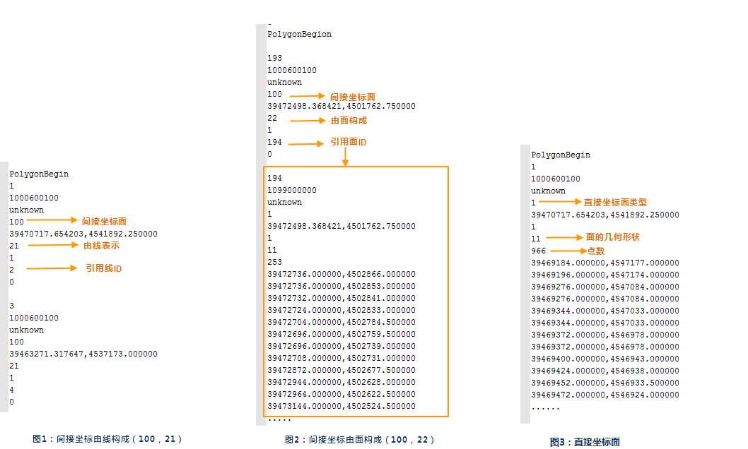
- Polygon description: Feature types 1 (direct coordinates) and 100 (indirect coordinates). Indirect types include 21 (line-referenced) and 22 (polygon-referenced). Direct coordinate polygons use vertex coordinates without references.

- Part 5: Annotation Elements: Between AnnotationBegin and AnnotationEnd. Contains: 1) Object ID; 2) Feature code; 3) Graphic style code; 4) Annotation type (1=Single-point, 2=Multi-point).
- Part 6: Attribute Elements: Between AttributeBegin and AttributeEnd. May contain multiple attribute tables, each starting with table name and ending with TableEnd.
- Part 7: Graphic Presentation Data: Enclosed between StyleBegin/RepresentationBegin and StyleEnd/RepresentationEnd.
VCT Configuration File
supports exporting point/line/polygon/text datasets and attribute tables to VCT files. Configuration files vary slightly between versions:
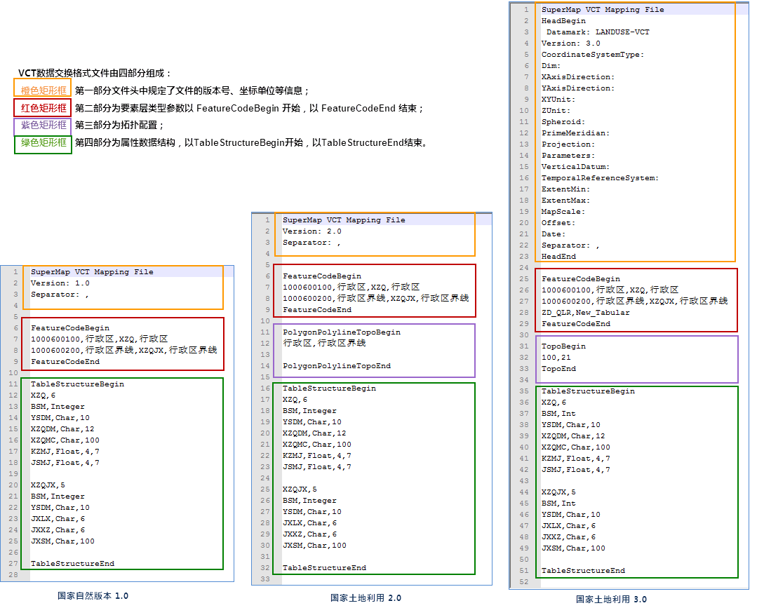 |
- File Header: All versions start with "SuperMap VCT Mapping File". VCT3.0 adds mandatory headers: Datamark=LANDUSE-VCT, Version=3.0. Other headers are optional.
- Feature Layer Types: Between FeatureCodeBegin and FeatureCodeEnd.
- Point/line/polygon/annotation configuration: Four fields (e.g., "1000600100,,XZQ,Administrative Region"): 1) Feature code; 2) Feature name; 3) Table name; 4) SuperMap dataset name.
- Attribute table configuration: Two fields (e.g., "ZD_QLR,New_Tabular"): 1) Table name; 2) SuperMap dataset name.
- Topology Configuration: VCT1.0 doesn't support topology.
- VCT2.0 Topology: Between PolygonPolylineTopoBegin and PolygonPolylineTopoEnd. Defines region-line relationships (e.g., "Administrative Region,Boundary Line").
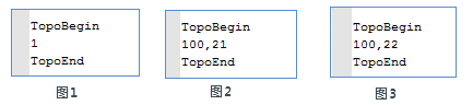
- VCT3.0 Topology: Type 1 (direct coordinate plane) has single field. Type 100 (indirect) uses two fields: 21 (line-based) and 22 (polygon-based).
- Table Structure Configuration: Consistent across versions between TableStructureBegin and TableStructureEnd.
- VCT3.0 types: Char, Int, Float, Date, Time, Datetime, Varchar, Varbin.
- VCT2.0 types: Char, Integer, Float, Date, Time, Varbin.