


↵
Feature Description
SuperMap iDesktopX supports adding object types according to S-57, CJ-57, or IENC standards to meet the needs of complex inland waterway environments, diverse navigation channels, and special scenarios with new data content, such as:
-
Localized Extend: When using the CJ-57 standard for inland electronic navigation charts in the Changsha area, due to unique river conditions, certain actual features cannot be represented by existing objects. In this case, a new object type suitable for local characteristics in Changsha can be added to ensure the accuracy and completeness of navigation channel data.
-
New Facility Support: For newly built inland navigation facilities (such as smart locks, dynamic buoys, etc.), the inland electronic navigation chart can be updated promptly by extending object definitions and property fields, providing the latest and accurate channel information support for inland waterway management departments and shipping companies.
Operation Steps
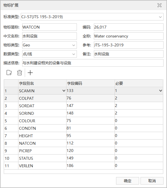
Taking the extension of the "Water Conservancy Facilities" object in the CJ-57 standard as an example, the following describes how to implement an extend in SuperMap iDesktopX.
- Refer to the "Detailed Object Specifications" section in the "Inland Electronic Navigation Chart Technical Specifications" to clarify the object info, property fields, and display symbol requirements for water conservancy facilities.
- Chart tab -> Extend group -> Extend button to open the Extend dialog box.
- The Extend dialog box consists of two parts. The upper part requires entering object info (Due to the uniqueness of objects, if the entered information duplicates an existing object, it will be highlighted in red):
- Standard Type: The standard types currently supported for extension in SuperMap iDesktopX include S-57 (the internationally通用 electronic chart standard), CJ-57 (the Chinese inland electronic navigation chart standard), and IENC (the international inland electronic navigation chart standard). For more information on standards and version numbers, please refer to Search Definition.
- Object Abbreviation: In CJ-57, the "Acronym" for water conservancy facilities is found to be "WATCON".
- Code: In CJ-57, the "Code" for water conservancy facilities is found to be "26017".
- Chinese Name: The Chinese name of the object, "Water Conservancy Facilities".
- Full Name: Usually the full English name, here it is "Water conservancy".
- Object Type: Default is spatial object (Geo). You can also set it to meta object (Meta), etc., according to the actual situation.
- Reference: Specify the规范 version number or standard code referenced when extending this object.
- Data Type: In CJ-57, the "Primitive Category" for water conservancy facilities is found to be "Point, Line".
- Remarks and Description: Add remarks or a more detailed description of the object.
- The lower part of the Extend dialog box is used to add property select fields for the new object:
- Toolbar: The toolbar, from left to right, includes the Add Field, Remove Field, and Object Attribute Expand buttons.
- Add Field and Remove Field are used to add or remove fields in the list below.
- Extend Attribute is used to extend the property fields of the object. In this example, we need to add the currently missing property field "Water Conservancy Category CATWCN".
- Field List Box:
- After adding a field, specify the specific property field by selecting the field alias (acronym). You can locate it by typing on the keyboard.
- The field encoding will be automatically filled in after selection.
- You need to manually set the constraint of the fields: 0 (Optional), 1 (Mandatory), 2 (Conditional). According to the CJ-57 attribute table regulations for water conservancy facility objects, M (Mandatory attribute) corresponds to 1, C (Conditionally mandatory attribute) corresponds to 2, and O (Optional attributes) corresponds to 0.
- Toolbar: The toolbar, from left to right, includes the Add Field, Remove Field, and Object Attribute Expand buttons.
- After filling in as shown in the figure above, click the OK button to complete the extend operation.
- After the extension is completed, you can check the newly added "Water Conservancy Facilities" object in two ways:
- Search Definition;
- Navigate to the bin/Resource/Chart/S57 folder under the root directory of the SuperMap iDesktopX product package:
- Check the object definition in the S57Objects.xml file:
<ObjectClass Acronym="WATCON" Code="26017" Type="GEO">

			<Name>Water conservancy</Name>

			<Definition>Water Conservancy Facilities</Definition>

			<References>JTS-195-3-2019</References>

			<Remarks>Water Conservancy Facilities</Remarks>

</ObjectClass> - Check the definition of the object's property fields in the S57ObjectsEnc31.xml file:
<ObjectClass Acronym="WATCON" Code="26017">

			<Primitives value="P/L" />

			<Name>Water conservancy</Name>

			<LocalName>Water Conservancy Facilities</LocalName>

			<Attributes>

			<Attribute Code="26012" Required="1" />

			<Attribute Code="133" Required="1" />

			<Attribute Code="76" Required="2" />

			<Attribute Code="147" Required="2" />

			<Attribute Code="148" Required="2" />

			<Attribute Code="75" />

			<Attribute Code="81" />

			<Attribute Code="95" />

			<Attribute Code="112" />

			<Attribute Code="120" />

			<Attribute Code="149" />

			<Attribute Code="186" />

			<Attribute Code="116" />

			<Attribute Code="301" />

			<Attribute Code="102" />

			<Attribute Code="300" />

			<Attribute Code="304" />

			<Attribute Code="158" />

			<Attribute Code="86" />

			<Attribute Code="85" />

			<Attribute Code="119" />

			<Attribute Code="118" />

			<Attribute Code="17077" />

			</Attributes>

			</ObjectClass>
- Check the object definition in the S57Objects.xml file:
-
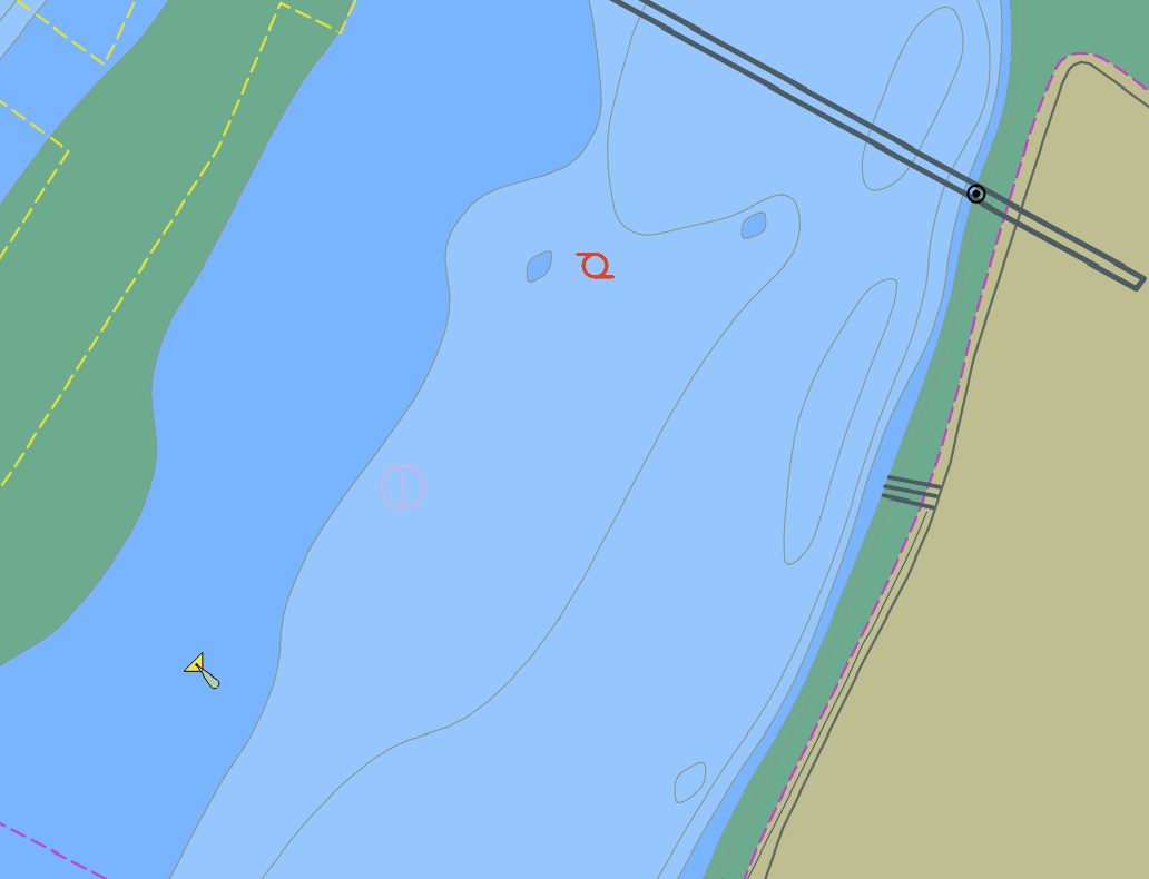
After completing the S-52 Display Extension, you can add "Water Conservancy Facilities" to a chart group via Create Feature Dataset and complete the full addition of the new extended object by drawing objects. The final effect is shown in the figure:
Related Topics