


After configuring the base map, create a unique value thematic map based on the traffic condition field of the road data, using green, yellow, and red to represent smooth, slow, and congested traffic, respectively. Set the visible scale of the layer to display two-way road conditions at small scales and all road conditions at large scales. Additionally, traffic condition maps for different times can be created, with specific steps as follows:
Large Scale Traffic Condition Maps
Add the line data from navinfo to the configured base map window. Create unique value thematic maps for three times: 6:00, 9:00, and 18:00, based on fields Condition6, Condition9, and Condition18, respectively. Field value 1 represents smooth traffic, field value 2 represents slow traffic, and field value 3 represents congested traffic. For example, in a field "Condition", value 1 indicates smooth, value 2 slow, and value 3 congested. Use green lines for single value 1, yellow for single value 2, and red for single value 3, as shown in the figure below:
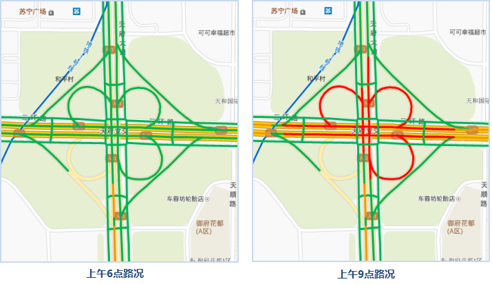 |
Set the minimum visible scale of the thematic map layer to 1:9028. To view the traffic conditions at a specific time point, set the layer settings of other times to not display.
Small Scale Traffic Condition Maps
According to the scale level of the map display, traffic conditions should also be mapped and displayed hierarchically. For example, at large scales, the traffic conditions of ramps can be displayed, while at medium scales, ramp conditions may not be displayed; at large scales, the traffic conditions of auxiliary roads are displayed, while at small scales, auxiliary road conditions are not displayed.
For roads in small scale maps, first ensure that the data fields contain two types of information: first, a field expressing single/double line and whether to display traffic conditions; second, a field expressing road congestion. Then, create a unique value thematic map for the roads using the congestion status field, and set the corresponding styles; specify a field or field expression to represent the single/double line situation or whether to display traffic conditions; set the offset distance for double-line traffic conditions to both sides, in units of 0.1mm. Specific steps are as follows:
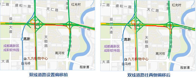 |
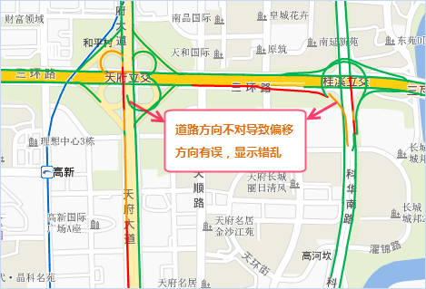
When zooming out the map scale to view traffic conditions, roads may overlap and intersect, making it unclear to see the congestion of two-way roads. Under such small map scales, to display the traffic conditions of double-line roads, SuperMap provides the "traffic line correction" function, which effectively achieves the desired effect. This function processes two attribute values: whether to display traffic conditions and the offset value for line data. For specific operations, refer to Traffic Condition Correction.
 |
- In the Layer Manager, double-click the traffic condition thematic map to open the "Thematic Map" panel. In the "Advanced" interface, check the "traffic situation" checkbox, set the "road grading" field, and configure the display of roads. Field value 0 means not to display traffic conditions, e.g., auxiliary roads at small scales; field value 1 means the road displaying traffic conditions is a single-line road, e.g., a ramp; field value 2 means the road displaying traffic conditions is a double-line road, e.g., a highway.
Note: The offset effect of the traffic situation thematic map only works for non-system symbols and does not support line symbols with IDs from System0 to System5. It is recommended to modify the line symbols for thematic maps that require offset. For specific operations, refer to Unique Value Thematic Map Properties Panel.
- In the numeric box to the right of "road offset", offset the double-line types in the traffic condition thematic map by a specified distance to both sides. A positive offset means shifting to the left side of the line direction, and a negative offset means shifting to the right side of the line direction, in units of 0.1mm. By offsetting roads on both sides, the traffic conditions of double-line roads can be clearly displayed even at small scales.