


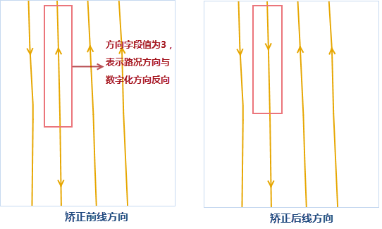
The principle for displaying dual-carriageway road conditions is to offset both lines of the road by specified distances towards opposite sides. The offset direction depends on the right (positive value) or left (negative value) side of the line's digitization direction. However, user data may contain dual-carriageway roads where both lines share the same digitization direction, leading to improper unilateral offsetting instead of bilateral separation. The "Traffic Line Correction" function resolves this by reversing the digitization direction of one line to create opposing directions.
The "Traffic Line Correction" function modifies source data. It's recommended to back up data beforehand. Note: The following examples use NavInfo data fields. For non-NavInfo data, select corresponding fields based on actual meanings.
- In the "Data" tab's "Data Processing" group, click "Traffic Line Correction" in the Gallery. Configure parameters in the dialog:
- In the "Correction Line" area:
- Select target road line dataset and related fields:
- Start Field: Start node field of line object.
- End Field: End node field of line object.
- Direction Field: Defines relationship between road direction and digitization direction. Specify field values for bidirectional/forward/reverse roads:
- Bidirectional: Road direction independent of digitization direction (value=1).
- Forward: Road direction matches digitization direction (value=2).
- Reverse: Road direction opposes digitization direction (value=3).
- Select target road line dataset and related fields:
- In "Reference Point" area: Set reference point dataset for direction correction, configure ID selection fields for geographic matching with line data's start/end fields.
- "Assist Settings" area standardizes road display types using unified values (0/1/2) for consistent small-scale map representation:
- 0: No traffic display (e.g., service roads in small scales)
- 1: Single-line roads (e.g., ramps)
- 2: Dual-line roads (e.g., highways)
For NavInfo data with varying codes for same road types, use SQL expressions to convert road type specified field values into 0/1/2 stored in "Display Type" field. Example: Service road codes 030a and 060a correspond to "Status" field value 0.
- After parameter configuration, click "OK" to execute correction. Result example:
 |
 |