


Feature Description
Extract Specific Lines (extract specific isolines) allows users to extract a specified number of isolines with specific values. Values can be directly input, automatically generated through range and interval settings, or imported from *.txt files.
- The source dataset for isoline extraction must be DEM or Grid dataset.
Example
Open the "Terrain" datasource in the "ExerciseData/RasterAnalysis" folder containing 5-meter resolution DEM data. This example uses this dataset for demonstration.
Feature Entry
- Spatial Analysis Tab -> Raster Analysis -> Surface Analysis -> Extract Specific Lines
- Toolbox -> Raster Analysis tools -> Surface Analysis -> Extract Isolines/Areas -> Extract Specific Lines
Steps
Start Value: Initial value for isoline generation.
End Value: Maximum value for isoline generation.
Step Size: Interval between adjacent isolines.
Segments: Total number of isolines in target dataset. The system automatically calculates this value after setting the step size.
Example: Start value=1100, End value=1200, Step size=20 will extract 6 isolines between 1100-1200 with 20-unit intervals.
- In the "Extract Specific Isolines" dialog, input specific values. Alternatively, click the Batch Add button to set parameters including start value, end value, step size, and segment count in the pop-up dialog. Click OK to return.
- Set common parameters including source data, target dataset, resampling coefficient, smoothing method, and smoothness. For parameter details see: Common Parameter Description.
- Supports importing/exporting isoline information via txt files, and deleting individual/all current isoline values. Toolbar buttons (left to right): Import, Export, Delete, Delete All.
- Click OK to complete extraction.
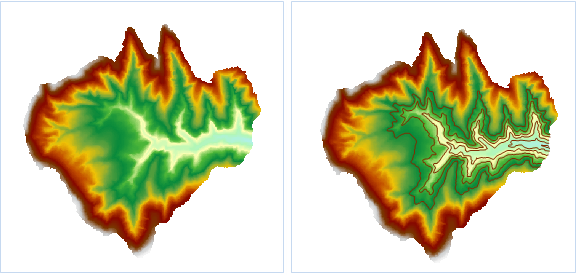
Figure: Extract Specific Isolines