


Feature Description
extract all lines, i.e., extract all isolines, by specifying parameters to extract all qualified isolines from the surface model.
- The source dataset for extracting isolines must be a DEM or Grid dataset.
Application Example
Open the 'Terrain' data source in the 'ExerciseData/RasterAnalysis' folder, which contains DEM data with a resolution of 5 meters. We use this data as an example.
功能入口
- In the Spatial Analysis tab -> Raster Analysis -> Surface Analysis -> Extract All Lines;
- Toolbox -> Raster Analysis tool -> Surface Analysis -> Extract Isolines/Areas -> Extract All Lines.
Parameter description
Base Value: The initial starting value when generating isolines. It is calculated forward or in both directions at intervals of the contour interval, so it may not be the value of the smallest isoline. Any number can be input as the base value. The default value is 0. For example, for DEM data with an elevation range of 220-1550, if the base value is set to 500 and the contour interval is 50, the result of extracting isolines is: the smallest isoline value is 250, and the largest isoline value is 1550.
Contour Interval: The interval value between two isolines. It, together with the base value, determines which isolines to extract.
After setting parameters, the system will automatically calculate and display the result info. The description of the result info is as follows:
Maximum Raster Value: The largest raster value in the selected source dataset, which is system information and cannot be changed.
Minimum Raster Value: The smallest raster value in the selected source dataset, which is system information and cannot be changed.
Maximum Isoline: The maximum value of isolines in the target dataset.
Minimum Isoline: The minimum value of isolines in the target dataset.
Number of Isolines: The total number of isolines in the target dataset.
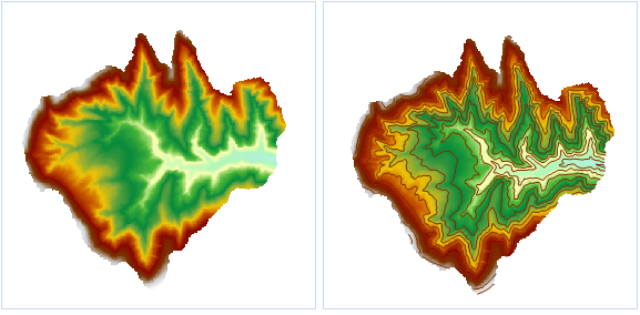 |
| Figure: Extract All Isolines |
- Set the common parameters for extracting isolines, including source data, target dataset, and parameters such as resampling factor, smooth method, and smoothness. For setting common parameters like source data, target dataset, and parameters, please refer to: Common Parameter Description.
- Set the base value and contour interval in the parameters.
- Click the "OK" button to complete the isoline extraction operation.
相关主题