


Feature Description
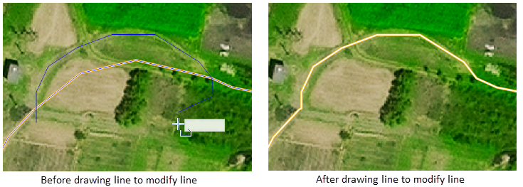
The draw line to modify line function adjusts the shape of a line object based on a newly drawn line, allowing you to quickly modify the line shape without editing nodes. It is very convenient for local adjustment of complex line objects and is suitable for many application scenarios, such as indoor workers modifying existing land class lines according to new boundary lines drawn from field surveys, or revising contour lines from preliminary curve results based on terrain. This function is only applicable to line layers.
Function Entry
- Edit Data tab -> Object Editing group -> Line editing -> Line Trimming -> Draw Line to Modify Border.
Operation Steps
- In the Layer Manager, click the edit button of the layer to set the layer as editable.
- In the Edit Data tab -> Object Editing group -> Line editing -> Line Trimming group, click the Draw Line to Modify Line button to execute the draw line to modify line operation.
-
If no line object is selected:After clicking Draw Line to Modify Line, move the mouse to the map; you will be prompted: "Please select the line object to modify." At this point, you need to select one or more line objects to modify.
-
After the selection is complete, or after selecting the line object first and then clicking Draw Line to Modify Line, the cursor changes to a crosshair.Move the mouse to the map; the cursor will change to a crosshair, and the prompt will say: "Draw a line that intersects the selected line." At this point, directly draw a line on the map that intersects the selected line. The program will automatically identify the intersection point.There is no need to precisely snap to the intersection point.Right-click to end the drawing, and the line modification is complete.
Related Topics