Line Split
Feature Description
Splits lines or regions using a drawn temporary split line.
The Line Split button becomes available only when there are editable layers with one or more selected objects in the current map.
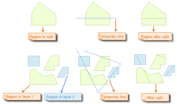
When multi-layer editing is enabled, the drawn temporary split line will divide all selected lines or regions across editable layers that it intersects, which may belong to different layers.
Feature Entry
- Features tab->Feature Editing group->Draw LineSplit.
Steps
- Set the object layers containing the lines or regions to be split in the map to editable status.
- Select target lines or regions by clicking. Alternatively, select multiple geometries using box selection or Shift+click.
- Click the Line Split button in the Feature Editing group under the Features tab to activate line split operation. The map will enter line split mode for line/region objects.
- Draw temporary split line: Move the cursor to the map and left-click to set the first point. Continue moving the cursor - a dynamic temporary line will follow. Left-click to add subsequent points.
- Right-click to complete the temporary split line drawing. The split operation will execute automatically, and the temporary line will disappear.
- Result: All selected lines/regions in editable layers intersected by the temporary split line will be divided into separate objects.
- Repeat step 4 for subsequent splits. To process additional data, add datasets and set their layers to editable before repeating step 4.
- To exit line split mode, click the Line Split button again to deactivate it.
Illustration of Line Split Operation:
 |
 Notes:
- When multi-layer editing is enabled, users can simultaneously split lines/regions across multiple editable layers.
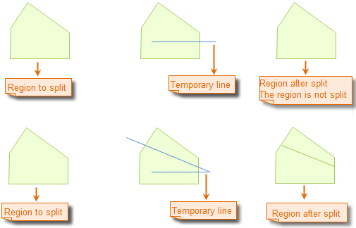
- Only geometries completely intersected by the temporary split line will be divided, as shown:


