


Instructions for use
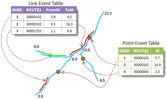
The event table records the route, scale and event Description of the point or line event in the form of an attribute table, such as the weather condition at the time of the traffic accident, the alcohol content in the driver's body, the speed at that time, the width of the road surface, the paving material, etc. Generate Spatial Data is to generate the corresponding point or line data (Route Data) in the space where the event in the event table is located according to the Route Dataset, so as to better help the analyst to fully understand such events.
Generate Spatial Data involves three roles: Route Dataset, Event Table, and Spatial Data. Application establishes and stores a dynamic relationship between the three. Because there is a one-to-one relationship between the event table and Spatial Data, it is necessary to ensure that there is no dynamic relationship between the events used to Generate Spatial Data when Generate Spatial Data. If the event table already exists in a dynamic relationship, you need to delete the relationship first and then Generate Spatial Data.
 |
For more information about Dynamic Segmentation relationships, see Dynamic Segmentation Relationship Management Overview .
Function entrance
- In the Traffic Analysis tab-> Dynamic Segmentation group, click the Dynamic Segmentation button and click the Generate Spatial Data button in the drop-down menu.
- Toolbox-> Traffic Analysis-> Dynamic Segmentation tool: Generate Spatial Data; or drag the tool to the Model Builder Window and double-click the function graph.
Parameter Description
Set the event table participating in Generate Spatial Data and the Datasource where Route Data is located. Note: The Dynamic Segmentation feature requires that the event table for Generate Spatial Data and the Route Data must be in the same Datasource.
- Event Table Data: Set the parameters related to Event Table Data. Includes an event table, an event type, a route identification field, a scale field, a scale offset field, and an Errors field. Note: When the event type is a point event, only one scale field needs to be set.
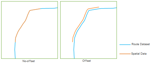
- The scale offset field is used to set a field. When Generate Spatial Data, Application will offset the position of the generated Spatial Data (point or LineM) according to the value of the field.
- The direction of the offset, plus or minus the offset, is related to the direction of the route. If the offset is positive, the resulting Spatial Data is offset to the left of the route; if it is negative, it is offset to the right of the route. During offset, Application will project the offset in X and Y directions respectively, and move in these two directions according to the projection length. The following figure shows the comparison between the effects of not setting the scale offset field and setting the scale offset field when Generate Spatial Data.
- The routing direction is based on the order of the routing nodes. The direction of the route points from the smallest node number to the largest. The left side of the route refers to the left side of the route direction, and the right side of the route refers to the right side of the route direction.
- Route Data: Set parameters related to Route Data. Includes the Datasource where the Route Data is located, the Route Dataset, and the Route ID field.
- Result Data: Set parameters related to Result Data, including the name of the generated Spatial Data.
- When you are ready, click the Execute button to perform this step.
Scale Offset Field Description
 |
Errors field description
The Errors field is directly written into the original event table (point event table or line event table) to describe the Errors in the event that the corresponding point or line is not generated. For a description of Errors, see the Errors field description .
 Precautions
If Spatial Data generated by an event exists under the Current Data source, new Spatial Data cannot be generated repeatedly unless the existing Spatial Data is deleted through the Relationship Management window.