


Generate Spatial Data involves three roles: Route Dataset, Event Table, and Spatial Data. When Generate Spatial Data, the Application will automatically establish and store the Dynamic Segmentation relationship among the three, that is, establish the corresponding relationship among the three according to the routing ID, scale field and other information. Dynamic Segmentation is mainly used to realize the linkage modification among the three roles. It is important to note that the three pieces of data that establish the Dynamic Segmentation relationship must be in the same Datasource.
 |
After the Dynamic Segmentation relationship is established, on the one hand, it is necessary to dynamically manage the event table, Route Data and Spatial Data according to their relationships; On the other hand, if you modify one of the data, such as the event table, the other data, such as Spatial Data, changes accordingly.
1. Dynamic SegmentationRelationship Management
2. Dynamic Segmentation Relationship Linkage
Dynamic SegmentationRelationship Management
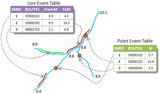
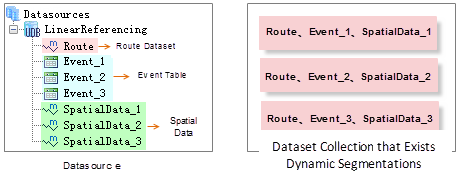
In The Dynamic Segmentation relationship, there is a one-to-many relationship between Route Data and event table, a one-to-many relationship between Route Dataset and Spatial Data, and a one-to-one relationship between event table and Spatial Data. As shown in the left figure below, in Datasource LinearReferencing, Dataset Route is Route Dataset. SpatialData _ 1, SpatialData _ 2, and SpatialData _ 3 are respectively the Spatial Data generated by Event _ 1, Event _ 2, Event _ 3, and Route. Then there are three Dynamic Segmentation relationships in the Datasource. That is, the Route Dataset can be shared by multiple event tables to generate multiple Spatial Data, but one event table can only correspond to one Spatial Data.
 |
Dynamic Segmentation Relationship Linkage
After Generate Spatial Data, a Dynamic Segmentation relationship is established between the Route Dataset used to Generate Spatial Data, the event table, and the generated Spatial Data. With this Dynamic Segmentation relationship, when one of the three is modified, the other two will automatically change accordingly. SuperMap calls it linkage modification, which is an important feature of Dynamic Segmentation function.
Currently, SuperMap Application supports linkage in the following ways:
- The Description of the event changed. In this case, linkage occurs between the event table and Spatial Data.
Modifying the Description of the event refers to modifying the general Property Field except the route identification field and scale field. For example, the speed limit information of the highway may be modified temporarily according to the changes of weather, construction and other factors. If the Description in the event table is modified, the Attributes of the Spatial Data generated from the event table will also be modified automatically. Similarly, when a general Property Field in the Spatial Data property table is modified, its corresponding event table will also change dynamically.
- The routing location where the event occurred has changed. This dynamically changes between the event table and the Spatial Data.
- Route change where the event occurred. In this case, the Spatial Data will change according to the modification of the Route Dataset, and the corresponding Route Data will not change when the Spatial Data is modified; the event table and the Spatial Data will be modified in a linked manner.
This situation is applicable to the situation that the route of the event needs to be modified due to data errors or changes, which can be divided into the following three situations:
- If the Space Geometry Info of LineM is modified, the Geometry Info of Related objects in the corresponding Spatial Data will also be modified automatically. If the location and scale values of the route where the event occurred change, such as a change in trend after a pipe repair, its shape and scale values may need to be modified. In this case, it is necessary to modify the space Geometry Info of LineM itself, such as rotation, movement, and modification of scale values. After modification, the Geometry Info of the Related objects in the corresponding Spatial Data will change accordingly, that is, the corresponding event and Spatial Data will be relocated.
- If the routing ID of a record in the event table is modified, the Geometry Info of the object associated with it in Spatial Data and the routing ID field in the property table will also change dynamically. The event table and its corresponding Spatial Data are shown in the following figure. After the route ID of the first record in the event table is changed from 1 to 2, the Spatial Data corresponding to the record is also changed and is located on the route with ID 2. of an Event in the Event Table
- event table has changed. In this case, the Attributes of Spatial Data will change equally with the change of the event table. The change of the
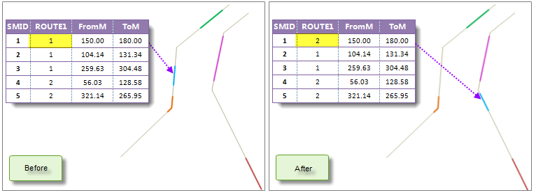
Figure: Modifying the Route ID Note: If the value of the Route ID field in the Route Dataset property table is modified, the property table can be modified successfully, but the corresponding event table and Spatial Data will not be changed.
The table structure of theevent table structure refers to the addition, deletion or Modify field. For example, a field is added to the event table of a highway toll station to describe the time when the station is established. After the table structure of the event table is modified, the Table Structure of the corresponding Spatial Data will also be modified automatically.
Modifying the location where the event occurs refers to modifying the scale value field in the event table or Spatial Data. If the scale value of a record (event) in the event table is modified, the Geometry Info of the point or line object corresponding to the event in the corresponding Spatial Data and the scale field of the corresponding record in the attribute table will also be modified accordingly; If the value of the scale field in the attribute table of the generated Spatial Data is modified, the Geometry Info of the corresponding object will also be modified, and the value of the scale field of the associated event in the event table will also change dynamically. If it is a line event, you can change the start scale or end scale, and the length and position of the event may change. As shown in the figure below, it is the change of the line corresponding to the event in the corresponding Spatial Data before and after the start scale and end scale of the first event in the corresponding event table are changed from (20.78, 79.37) to (150.00, 180.00) after Generate Spatial Data. When the scale value of the event changes, the corresponding Spatial Data will also be modified automatically.
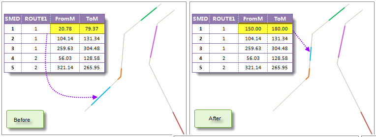 |
| Figure: Modifying the Scale Value of an Event in the Event Table |
Note: If there is no intersection between the modified scale value and the M value of the corresponding route, for example, the modified start scale and end scale are 26 and 60 respectively, while the M value of the corresponding route ranges from 3 to 20, the Geometry Info of Spatial Data will not change; If a part of the modified line event is located on the route, the corresponding Spatial Data will be automatically modified to only correspond to this part of data.
 Precautions
- Events used to Generate Spatial Data must include a route identification field and a scale field (a point event contains a scale field, and a line event contains a start scale field and an end scale field). The value of the route identification field is used to locate the point or line corresponding to the event on the correct route, and the value of the scale field enables the point or line corresponding to the event to be located correctly. The routing ID field, scale field, and other attributes that describe the event in the event table are included in the property table of the generated Spatial Data.
- The generated Spatial Data will add a field named "Event _ SMID" "in the Result Dataset to store the SMID of the corresponding event in the event table. As a special reminder, the content of this field cannot be modified, otherwise the linkage result may be wrong.
- Because There is a one-to-one relationship between an event table and Spatial Data, if an event table already has a Dynamic Segmentation relationship, it cannot be used to Generate Spatial Data again. Unless an existing Dynamic Segmentation relationship is deleted.
- After a Dynamic Segmentation relationship is established, if a piece of data (Route Dataset, event table, or Spatial Data) with a Dynamic Segmentation relationship is deleted directly, Application will pop up a dialog box to prompt the user whether to delete the association relationship and Delete Dataset. Because the data cannot be manipulated until the Dynamic Segmentation relationship between the data and other data is deleted. Select "Yes" to delete the Dynamic Segmentation relationship between the data and other data and delete the data; select "No" to cancel the current operation.