


There are many types of map projections, generally classified according to two standards: one is by the nature of projection distortion, and the other is by the method of projection construction.
Classification by Projection Distortion Properties
According to the nature of projection distortion, they can be divided into the following categories: Conformal Projection, Equal-area Projection, and Arbitrary Projection.
- Conformal Projection
Conformal projections preserve the similarity of infinitesimal figures. At any point, the scale factor is constant in all directions—forming a distortion circle—but the radius varies at different points. On a large scale, the projected shape is not entirely similar to the actual ground shape. Since there is no angular distortion, it facilitates measuring directions and angles on the map, making it commonly used for maps requiring high accuracy in angles and directions, such as nautical charts, ocean currents, and wind maps. Due to significant area distortion, areas cannot be measured accurately.
- Equal-area Projection
Equal-area projections maintain equal areas, facilitating comparison and measurement of areas. They are commonly used for natural and economic maps requiring high area accuracy, such as geological, soil, land use, and administrative maps.
- Arbitrary Projection
Arbitrary projections are neither conformal nor equal-area; distortion exists in all aspects but is moderate. Among arbitrary projections, a special type is the equidistant projection, where the scale factor along meridians is 1 in normal aspect projections, and along vertical circles in oblique or transverse projections. Arbitrary projections are often used for educational maps, scientific reference maps, and general world maps.
Classification by Projection Construction Method
According to the method of projection construction, they can be divided into two categories: geometric projections and analytical projections.
Geometric projections involve projecting the graticule directly or with additional conditions onto a geometric developable surface, which is then unfolded into a plane. This category includes azimuthal, conic, and cylindrical projections. Based on the positional relationship between the projection surface and the sphere, they can be further classified into: normal aspect, transverse aspect, and oblique aspect projections. As shown in the figure below:
 |
Azimuthal Projection: Uses a plane as the geometric developable surface, tangent or secant to the ellipsoid, projecting the graticule onto the plane. There is no distortion at the point of tangency or along the secant lines; distortion increases with distance from these points.
Conic Projection: Uses a cone as the geometric developable surface, tangent or secant to the ellipsoid, projecting the graticule onto the cone. This projection is suitable for mid-latitude regions extending along parallels and is commonly used for maps of China.
Cylindrical Projection: Uses a cylinder as the geometric developable surface, tangent or secant to the ellipsoid, projecting the graticule onto the cylinder. This projection type is generally suitable for maps of equatorial regions and world maps.
Analytical projections derive the graticule directly using analytical methods without auxiliary geometric surfaces. They mainly include: pseudo-azimuthal projection, pseudo-conic projection, pseudo-cylindrical projection, and polyconic projection. These are not elaborated further here.
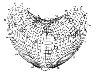
Pseudo-Azimuthal Projection: Modified from azimuthal projections. In the normal aspect, parallels remain concentric circles; except for the central meridian being a straight line, other meridians are curves converging at the center of the parallels.
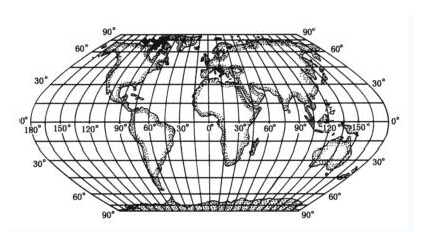
Pseudo-Cylindrical Projection: Modified from cylindrical projections. Based on the normal cylindrical projection, parallels remain parallel straight lines; except for the central meridian being straight, other meridians are curves symmetric about the central meridian.
Pseudo-Conic Projection: Modified from conic projections. Based on the normal conic projection, meridians remain concentric arcs; except for the central meridian being straight, other meridians are curves symmetric about the central meridian.
Polyconic Projection: Designed by imagining multiple conical surfaces tangent to the sphere. Parallels are coaxial arcs with centers on the central meridian; the central meridian is straight, and other meridians are curves symmetric about it.
 |
 |
| Figure: Schematic diagram of graticule shape for pseudo-azimuthal projection (Source: Internet) | Figure: Schematic diagram of graticule shape for pseudo-cylindrical projection (Source: Internet) |
 |
 |
| Figure: Schematic diagram of graticule shape for pseudo-conic projection (Source: Internet) | Figure: Schematic diagram of graticule shape for polyconic projection (Source: Internet) |
- Geometric Projections
- Analytical Projections
Related Topics
Explanation of Datum Transformation Methods