


Commonly used coordinate systems include the 1954 Beijing Coordinate System, 1980 Xi'an Coordinate System, WGS 84 Geodetic Coordinate System, and the currently required 2000 National Geodetic Coordinate System. The parameters for each coordinate system are as follows:
| Coordinate System | Reference Ellipsoid | Semi-major Axis | Flattening |
| 1954 Beijing Coordinate System | Krasovsky | 6378245 | 1:298.3 |
| 1980 Xi'an Coordinate System | IAG-75 International Ellipsoid | 6378140 | 1:298.257 |
| WGS 84 | WGS 84 | 6378137 | 1:298.257223563 |
| 2000 National Geodetic Coordinate System | CGCS2000 | 6378137 | 1:298.257222101 |
From the above parameters, it can be seen that the reference ellipsoids and datums of the four coordinate systems are all different. Therefore, the coordinate values of the same point on Earth vary across different coordinate systems. When converting data from one coordinate system to another, it is first necessary to clarify the issue of rigor in the transformation. Specifically, coordinate transformations within the same ellipsoid are rigorous, while transformations between different ellipsoids are not rigorous. For example, the transformation from geodetic coordinates in the 1954 Beijing Coordinate System to Gauss-Krüger plane rectangular coordinates in the same system falls within the same reference spheroid category, making the transformation process rigorous. In contrast, the transformation from the 1954 Beijing Coordinate System to the 2000 National Geodetic Coordinate System involves different ellipsoids, and there is no single set of parameters that applies uniformly across all locations on Earth. Therefore, a transformation model is required to convert spatial points from one reference ellipsoid datum to another. The process of datum transformation involves solving for the transformation parameters. Only after obtaining the transformation parameters and performing the coordinate system conversion under the same ellipsoid datum can the final data conversion be completed accurately; otherwise, the data cannot be correctly transformed.
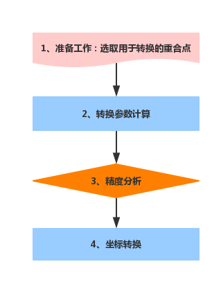
Coordinate Transformation Technical Process
- Preparation: Collect and organize coordinate data of common points for transformation, and analyze and select common points for the conversion. The number of common points should meet requirements, and they should be reliable, highly accurate, and evenly distributed to cover the entire survey area.
- Transformation Parameters Calculation: Based on the existing common point results and transformation requirements, determine the transformation model for parameter calculation. The calculation should involve redundant common points and use the least squares method as a constraint to compute the transformation parameters.
- Accuracy Analysis: Calculate the coordinates of common points in the target coordinate system using the transformation parameters, analyze the transformation residuals (the differences between the converted coordinates and the known coordinates of common points), and compute the mean square error of the coordinate residuals to evaluate the accuracy of the coordinate transformation. Gross errors should be eliminated based on the residual tolerance (three times the mean square error of residuals). If the transformation accuracy assessment is unsatisfactory, reselect common point coordinates for parameter calculation.
- Coordinate Transformation: Calculate the coordinates of other features in the target coordinate system using the final qualified transformation parameters.
 |
Notes:
|