SuperMap provides multiple tools to create map tiles, which is used to improve the access efficiency of online map services. This article will introduce the map tile production and use flow from cartography, tiles to use map services.
Map producing and publishing
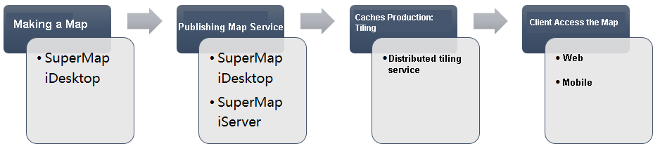
SuperMap iDesktop is the desktop GIS tool of SuperMap. It is the professional GIS data analysis, processing and cartography platform. This article recommends to use SuperMap iDesktop to create data and map. This tool supports to quickly publish map data as SuperMap iServer map services.
Produce maps
As a traditional cartography tool, SuperMap iDesktop has the 2D and 3D cartography capacity. And it provides the rich and custom 2D and 3D symbols.
Please refer to SuperMap iDesktop Help for more information.
Publish map services
SuperMap iDesktop supports to quickly publish the local and remote data, map in workspace as SuperMap iServer services. The service types can be REST service, OGC standard service and so on.
Please refer to SuperMap iDesktop Help for more information about the details.
You can also Publish services through SuperMap iServer.
Producing map tiles: tiling
The distributed tile tasks provided by SuperMap iServer can add the multiple tile nodes in different computers, implement that multiple computers tile together. The distributed tile service supports to tile for all published map services. The service data source can be SuperMap workspace, remote WMS service, remote WMTS service, remote REST Map service, SuperMap cloud service, Bing Maps service, Tianditu service, MBTiles files, SMtiles files and so on.
You can split the map tiles according to the specified logic, and store them in the FastDFS and MongoDB distributed file system. You can store map tiles to .smtils based on MBTiles standard. You can also save the map tiles in local disk according to the SuperMap V5.0 cache strategy. Using distributed tile service can perform tile task for the one or more vector layers and attributes information in map service, which gets SVTiles vector tiles and UTFGrid attributes. Please refer to Map tile types .
If you use distributed tile task, the map tiles, vector tiles and attribute tiles all can be used by map services, and there is no need to configure again. If you modified the default storage path or other custom settings, you can Configure map service to use the cached tiles.
So we recommend to use distributed tile service to create the map tiles. Please refer to Distributed Tiling service.
In addition, you can use other tools to create SuperMap UGC format tiles for the workspace data, such as SuperMap iDesktop and SuperMap iObjects.
Using map services
The published maps in client and the pre-tiled map tiles is to improve the efficiency of displaying map. So it plays a role in client-side. You can access these tiles online, and also put these tiles in mobile side.
Online access
The map services of SuperMap iServer can be used by multiple terminals, such as SuperMap iDesktop, iObjects, iClient, and iMobile etc. But the common used scene is the online map service on Web side and mobile side.
For a map service and existing tiles, the output images request methods of client online access:
- Browse the map through .flash, .flash3d, .javascript, .vectortile and .silverlight of map resource. At this time, it needs to make sure that the map fixed scale and the existing scale stay the same. The image format of ouput request is the same with the existing tiles.
- Send the request to the server through the tileImage resource. It can request the specified tiles according to the scale, tile row, tile column, tile format and so on. It needs to confirm that the request parameters and tile size stay consistency;
- Access map service through Web client or mobile. You can develop a map browse script, sending request to the map service.
When accessing the SuperMap iServer map services through Web or mobile, If the server uses the existing map tiles, it can call the tiles directly, which improves the online access efficiency. Now it supports the Web tool: iClient for Flash, iClient for JavaScript, iClient for Silverlight, iClient for 3D. Mobile tool: iClient for Android, iClient for iOS, iClient for Windows 8, iMobile for iOS and iMobile for Android.
Except for the map tiles, SuperMap iServer also provides the vector tiles and attribute tiles. Take the grid tiles as the base map; overlay the vector POI data render; So this ensures the maps output efficiency, and ensures the timeliness demanding POI, route data update quickly, also supports users frequently mouse interaction.
Offline access
You can access the map service of SuperMap iServer through iClient or iMobile on terminals. But limited by the network, the downloading tiles on mobile side is still can not meet the requirement. So the server provides the application of map tile offline. That is, create the map tiles as a offline map package (*.smtiles or *.mbtiles). Download it or copy it to the mobile terminal.