Raster Data Basic Concepts
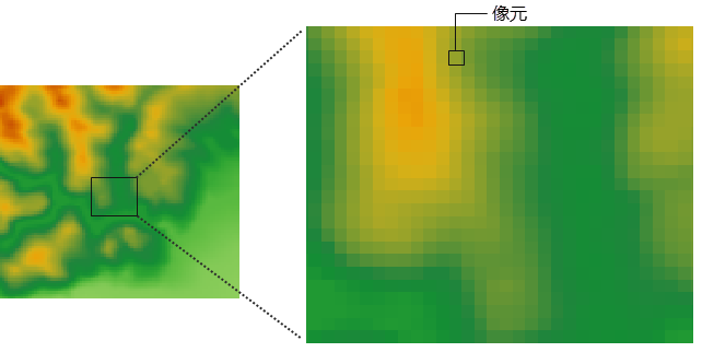
Raster Data structure is to divide a plane space into rows and columns regularly to form a regular grid, that is, pixel matrix. Pixel is the most basic information storage unit of Raster Data, and each pixel has a given attribute value to represent a geographical entity or a phenomenon in the real world.
 |
Some of the basic concepts associated with Raster Data are as follows:
- Pixel/Pixel: Both pixel and pixel refer to the smallest constituent unit in Raster Data. Pixel is often used as a synonym for pixel, which is short for image element and is often used to describe Image Data, while pixel is often used to describe Raster Data.
- Pixel Value: In Raster Dataset, each pixel (pixel) has a value. A pixel has an attribute value, and the pixel has a certain spatial resolution, that is, it corresponds to a certain range of the surface area, so the pixel value represents the dominant element or phenomenon of the area covered by the pixel. For example, the spectral values in Satellite Image and aerial photos reflect the reflectance of light in a certain band; the elevation values of the DEM grid represent the surface elevation above the mean sea level, and the pixel values of the slope map, aspect map and watershed map generated by the DEM grid represent their slope, aspect and watershed attributes, respectively; The category values in the Land Use classification map, such as cultivated land, forest land, grassland, etc., can also represent the quantitative values of precipitation, pollutant concentration, distance, etc. In addition, the pixel value can be an integer or a floating point number.
- Rows and Columns: a group of pixels in the X-axis direction of the grid constitutes a row; similarly, a group of pixels in the Y-axis direction constitutes a column. Each pixel in Raster Data has a unique row and column coordinate.
- Resolution: Various resolutions are involved in Raster Data, such as spatial resolution, spectral resolution, time resolution and radiometric resolution of Remote Sensing Imagery.
- Spatial Resolution: Spatial resolution, also known as pixel size, is the size of the area covered on the ground represented by a single pixel, in meters or kilometers. For example, one pixel of American QuickBird commercial Satellite Image is equivalent to the ground area of 0.61 m × 0.61 m, and its spatial resolution is 0.61 m; one pixel of Landsat/TM multi-band image covers the ground area of 28.5 m × 28.5 m, and its spatial resolution is 28.5 m. When
representing the same size area of the earth's surface, the image with high spatial resolution needs more pixels than image with low spatial resolution, that is, the grid with smaller pixel size needs more rows and columns to represent, so that more information and details of the earth's surface can be displayed. Therefore, the higher the spatial resolution is, the more the details of the surface are stored, the larger the storage space is, and the longer the Data Processing time is; on the contrary, the lower the spatial resolution is, the coarser the surface information is, but the storage space is smaller, and the processing speed is faster. Therefore, when choosing the pixel size, that is, spatial resolution, it is necessary to take into account the requirements of practical applications for the level of detail of information, as well as the requirements for storage and Data Processing time and speed.
- Spectral Resolution: refers to the imaging band range, the finer the division, the more bands, the higher the spectral resolution. Generally speaking, the more bands the sensor has and the narrower the band width is, the easier it is to distinguish and identify the information of ground objects.
- Time Resolution: refers to the minimum time interval between two adjacent remote sensing observations in the same area. When the time interval is large, the time resolution is low; conversely, when the time interval is small, the time resolution is high.
- Radiation resolution: refers to the minimum variation of electromagnetic radiation intensity reflected or radiated by the target that can be resolved by the sensor. Describes the ability of the sensor to resolve the object being viewed in the same portion of the electromagnetic spectrum.
- Spatial Resolution: Spatial resolution, also known as pixel size, is the size of the area covered on the ground represented by a single pixel, in meters or kilometers. For example, one pixel of American QuickBird commercial Satellite Image is equivalent to the ground area of 0.61 m × 0.61 m, and its spatial resolution is 0.61 m; one pixel of Landsat/TM multi-band image covers the ground area of 28.5 m × 28.5 m, and its spatial resolution is 28.5 m. When
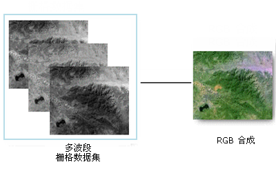
- Band: refers to the electromagnetic wave with definite wavelength. The commonly used bands in remote sensing technology are visible light band, Near Infrared Band, middle infrared band, thermal infrared band and far infrared band. Image Data can be divided into single-band images and multi-band images. Single-band images are generally described by black and white grayscale maps, while multi-band images are described by RGB composite color maps. A RGB composite map can be created using a combination of any three available bands from the multi-band Raster Dataset, as shown in the following figure. An example of a single-band Raster Dataset is a Digital Elevation Model (DEM), as well as a single-band orthophoto image sometimes referred to as a panchromatic or grayscale image. Most Satellite images have Multibands, which typically contain values within a range or band of the electromagnetic spectrum.

Single Band Data Synthesis - Image Pyramid: In order to reduce the amount of image transmission data and optimize the display performance, it is sometimes necessary to Create Image Pyramid for the image. Image Pyramid is a collection of images with a series of resolutions from fine to coarse generated according to certain rules. Image Pyramid technology establishes a series of Image Layers with different resolutions through the Image Resampling Method. Each layer is divided and stored, and the corresponding Spatial Index mechanism is established, so as to improve the Display Speed when zooming and browsing images. For the Image Pyramid shown in the figure below, the bottom is the representation of the original highest resolution of the image, which is 512 × 512 image resolution. The higher the image is, the smaller the resolution is, which is 256 × 256 and 128 × 128 respectively. The top is the image with the lowest resolution of Image Pyramid, which is 64 × 64. So this Image Pyramid has four layers, or four levels of resolution. Obviously, the higher the image resolution of the image, the more levels the Image Pyramid has. For an image with an image resolution of 2a × 2b (a > B), a pyramid of (b-6) + 1 layers will be established in SuperMap.
After the Image Pyramid is
Image Pyramid established, the system will obtain the Image Pyramid to display the data every time the image is browsed. When the user enlarges or reduces the image, the system will automatically select the most appropriate pyramid level to display the image based on the user's Display Scale.
Source of Raster Data
Raster Data is usually sourced in the following ways:
- Remote sensing data: The digital image obtained by means of remote sensing is a sequence of pixel values recorded in digital form after the remote sensing sensor scans and samples the radiation and reflection energy of the ground scene at a specific time and in a specific area and quantifies them according to different spectral bands.
- Image scanning: The map is scanned by a scanner and converted into raster data. For the scanned image, the gray value of each pixel corresponds to the attribute table to obtain the pixel value, and then the pixel value is stored as Raster Data through raster coding.
- Vector Data Conversion: Convert Vector Data to Raster Data using Vector Data Rasterization and Interpolation Analysis.
- Manual acquisition: It refers to dividing the grid evenly on the thematic map, determining the attribute values of the grid one by one, and finally forming the Raster Data file.
The Raster Data used in SuperMap can be digital aerial photos, Satellite images, digital pictures, and scanned pictures; It can also be the Analyst Result obtained by using some functions of the SuperMap Raster Analysis, such as distance map, mountain shadow map, etc.; in addition, Raster Data can also be obtained by interpolating the sample data.
 Related topics
 Raster Data spatial representation
 Raster Data compression encoding


