



Generate Configuration File
Instructions
Generate Configuration File is used to generate a configuration file in *.scp format based on oblique photogrammetry 3D model data. By loading the *.scp file in the scene, batch loading of oblique photogrammetry 3D model data and flow field browsing can be achieved.
Entry
- 3D Data tab -> Oblique Photogrammetry group>- Data Management drop-down button-> Generate Configuration File button
Steps
- On the 3D Data tab, in the Oblique Photogrammetry group, from the Data Management drop-down menu, click the Generate Configuration File button. The "Generate Oblique Photogrammetry Configuration File" dialog box appears.
- Source data settings:
- Source Path: Click the browse button to the right of "Source Path", select the folder containing the OSGB data in the "Browse for Folder" dialog box, or directly enter the folder path of the OSGB data in the text box.
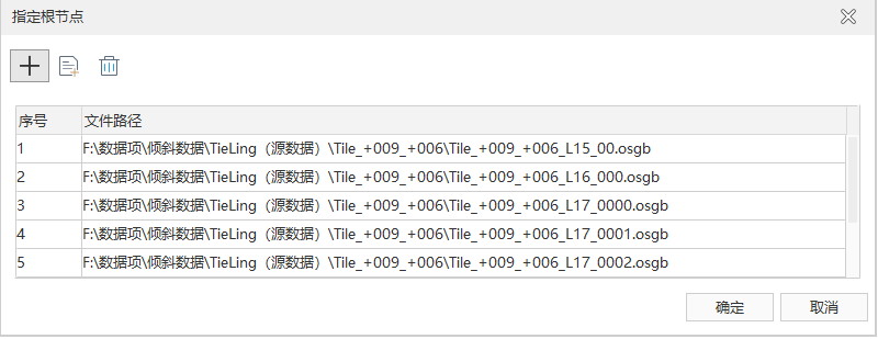
- Specify Root Node: Specify the root node, i.e., the coarsest level of the data. Click the "Specify Root Node" button to display the "Specify Root Node" dialog box as shown below. Use the toolbar tools to delete or add root node files. By adding oblique photogrammetry files based on conditions, you can batch add all root node files that meet the custom conditions (file names represented by wildcards) in the specified folder to the file list.
- Metadata: Metadata describes basic information such as the reference point and projection of the oblique photogrammetry 3D model data. Click the file browse button to the right of "Metadata", select the metadata file in the "Browse for Folder" dialog box to set the center point for the oblique photogrammetry data.
- Result data settings:
- Storage Path: Set the save path for the *.scp file. Click the file browse button on the right to select the file save path, or directly enter the save path in the text box. The default storage path is the source OSGB file path.
- Target File Name: Set the name of the *.scp file. The default value is Config. Enter a string directly in the text box to customize the name.
- Geographic Reference Origin: Also known as the model center point position, determined by setting longitude (X), latitude (Y), and elevation (Z). The default value is (0, 0, 0).
- ENU: If the source OSGB data uses the ENU (East-North-Up) coordinate system, it is recommended to check this check box to ensure the correct coordinate position of the data.
- Offset: After checking the ENU check box, you can set offset values along the X, Y, and Z directions to translate and adjust the data under the ENU coordinate system.
- Projection Settings: Used to set parameters for data coordinate projection transformation. Currently, projection settings provide three methods:
- Reset Coordinate System: Click the "Reset Coordinate System" button at the top of "Projection Settings". The "Coordinate System Settings" dialog box appears, select a projection as the coordinate system for the target file. For detailed operations on setting the target projection, please refer to the "Projection Settings" window.
- Import Coordinate System: Click the "Import Coordinate System" button at the top of "Projection Settings". In the "Import Coordinate System File" window that appears, select the projection information file and import it. At the same time, the detailed coordinate system information of the selected projection file will be displayed in the text box below.
- Copy Coordinate System: Click the "Copy Coordinate System" button at the top of "Projection Settings". In the "Copy Coordinate System" window that appears, select the coordinate system of the dataset. At the same time, the detailed coordinate system information of the selected dataset will be displayed in the text box below.
- After setting the relevant parameters, click the "OK" button to execute the operation of generating the configuration file from the OSGB files.
 Notes:
- If the added folder contains subfolders, the subfolders containing OSGB files will be added to the folder list, and a *.scp configuration file will be generated.
- If the OSGB files in the added folder are missing or invalid, the output window will prompt a failure message, such as: "Failed to add folder “D:\data”, please check whether the OSGB files under this folder are complete!". If the *.scp file generation fails, the output window will also prompt a failure message.
- If the metadata file (i.e., the xml file attached to the OSGB) is imported, the system will automatically fill in the geographic reference origin and projection coordinate system.