


The directory structure of map tiles varies depending on the tile version. SuperMap iDesktopX currently supports six different versions of map tiles.
- Version 2.0 corresponds to IS .NET tile strategy, suitable for products from SuperMap IS .NET 6.0 official release and above.
- Version 2.1 uses the new tile scheme of IS .NET strategy, compatible with SuperMap IS .NET 6 Service Pack 2 and above.
- Version 3.0 corresponds to iServer 2.0 tile strategy, designed for SuperMap iServer Java 2008 official release and above (currently unsupported).
- Version 3.1 employs the new tile scheme of iServer 2.0 strategy, applicable to SuperMap iServer Java 2008 Service Pack 2 and above (obsolete).
- Version 4.0 follows iServer 6R tile strategy, compatible with iServer Java 6R official release and above (obsolete).
- Version 5.0 adopts the new iServer 6R tile strategy, designed for SuperMap iServer Java 6R(2012) Service Pack 1. Only version 5.0 map tiles support tiling mode: generate tiles.
The directory structure mainly follows three tile strategies: iServer 6R, iServer 2.0 and IS .NET, organized by scale levels with tiling starting from the top-left corner of specified range. Versions 2.0 and 2.1 use IS .NET strategy; versions 3.0 and 3.1 use iServer 2.0 strategy; versions 4.0 and 5.0 adopt iServer 6R strategy.
The following sections detail directory structures of these three tile versions:
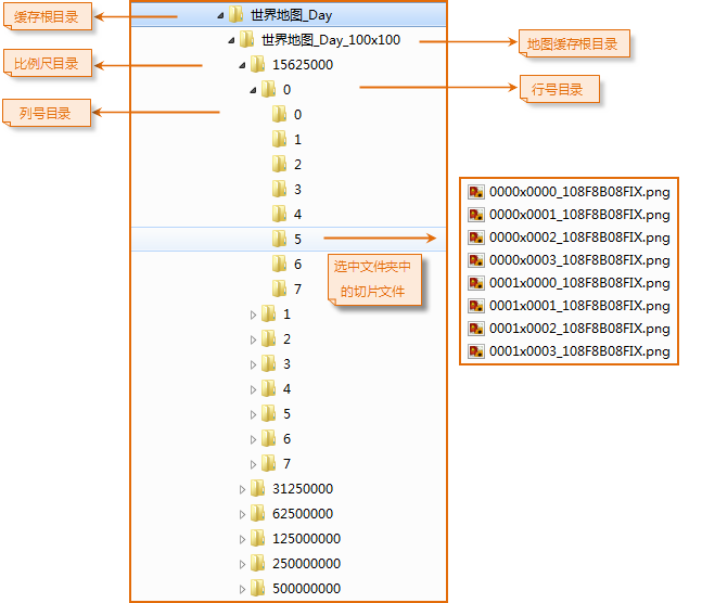
iServer 6R Tile Directory Structure
The iServer 6R tile strategy serves UGC (Universal GIS Class) series products, including SuperMap desktop software, SuperMap Objects Java/.NET 6R component platforms, and SuperMap iServer 6R server products.
The iServer 6R tile directory contains six hierarchical levels:
 |
| iServer 6R Tile Directory Structure Explanation |
- Level 1: Root directory with customizable name specified during tile generation.
- Level 2: Map tile directory named as "MapName_Width×Height" (hexadecimal dimensions, e.g., 100×100 represents 256×256 pixels).
- Level 3: Scale directories named with actual scale values (e.g., 15625000).
- Level 4: Row number directories using decimal numbering, representing spatial regions in vertical tiling order (may include negative values).
- Level 5: Column number directories using decimal numbering, representing spatial regions in horizontal tiling order (may include negative values).
- Level 6: Tile image files named as "RowxCol_MapHashCode.postfix" (e.g., 0000×0001_108F8B08FIX.png).
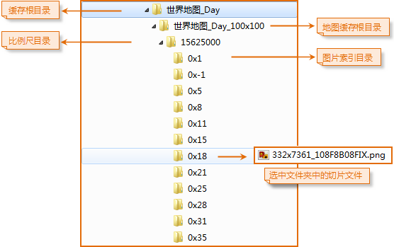
IS .NET Tile Directory Structure
As SuperMap's earliest tile strategy, IS .NET adopts layered tiling approach with update considerations for coordinate systems, map styles and layer bounds. Primarily used by SFC (SuperMap Foundation Class) series products.
The IS .NET 2D tile directory contains five levels:
 |
| IS .NET Tile Directory Structure Explanation |
- Level 1: Customizable root directory.
- Level 2: Map directory with hexadecimal dimensions in name (e.g., 100×100 = 256×256 pixels).
- Level 3: Scale directories named with actual scale values.
- Level 4: Tile index directories formatted as "X×Y" (column and row indices).
- Level 5: Tile images named as "centerIndex_MapHashCode.postfix" (e.g., 332×7361_108F8BFIX.png).
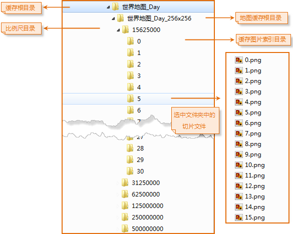
iServer 2.0 Tile Directory Structure
Similar to IS .NET strategy, this structure contains five levels for SuperMap iServer 2.0 products:
 |
| iServer 2.0 Tile Directory Structure Explanation |
- Level 1: Customizable root directory.
- Level 2: Map directory with decimal dimensions in name (e.g., 256×256 pixels).
- Level 3: Scale directories named with actual scale values.
- Level 4: Column index directories ({Index_x}) representing horizontal tile positions.
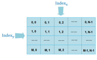
- Level 5: Tile images named with row index (Index_y.postfix), where filename indicates vertical position (e.g., 15.png = row 15).
Related Topics