


In the process of producing map tiles, variations in data types, business requirements, and technical environments may lead to differences in tile generation efficiency, storage costs, and rendering quality.
This document provides best practices for map tile production, covering tile type selection, hardware and parameter configuration, and map data optimization recommendations to help you generate high-quality map tiles efficiently and reliably.
Tile Type Explanation
Tile Type:
SuperMap iDesktopX supports generating vector tiles or raster tiles. These tile types serve different application scenarios and should be selected according to specific requirements.
| Tile Type | Tile Features | Application Scenarios |
| Raster Tile | Binary images, fastest rendering, no client requirements | Base maps without interactive queries |
| Vector Tile | Pixel coordinates, complex styling, requires client parsing for dynamic rendering | High-precision display, dynamic style modification, attribute queries |
Vector tiles comply with the Mapbox MVT specification, with styling adhering to Mapbox GL version 8 style.json standards. When generating vector tiles in SuperMap, style conversions may cause discrepancies with original effects due to unsupported style elements. Manual style adjustments can resolve these issues.
Data and Coordinate System Requirements
| Tile Type | Data Requirements | Coordinate System Requirements |
| Raster Tile | Does not support video datasets, model datasets, or volume datasets | None |
| Vector Tile | Supports only point, line, polygon, and text datasets | Does not support planar coordinate systems |
Configuration Recommendations
Hardware Configuration Recommendations
CPU performance and disk I/O significantly impact tile generation efficiency. Machines with high-frequency CPUs and solid-state drives (SSD) are recommended. Store original map data on SSDs for optimal read performance. Storage media for output tiles has lower I/O requirements.
| Map Bounds | CPU Cores | RAM | Disk & Network I/O |
| County-level | 16 | 32GB | SSD with 500MB/s, Gigabit network (shared directories require gigabit bandwidth) |
| City-level | 32 | 64GB | |
| Provincial-level | 64 | 128GB | |
| National-level | 128 | 256GB |
Original Map Optimization Recommendations
Before tile production, optimize data and map configurations to improve rendering efficiency. Use Maps tab → Cartography group → Performance Diagnosis to identify optimization areas. A map refresh time under 1 second (ideally 300ms) indicates acceptable performance. Focus on these common issues:
- Coordinate System: Ensure data coordinate system matches map display coordinate system
- Simplify dense nodes in geometries
- Split complex objects with excessive sub-objects
- Filter excessively small objects to improve browsing speed without losing information
- Balance anti-aliasing usage between visual quality and performance
- Simplify complex geometries through line smoothing or resampling
For detailed diagnosis information, see: Map Performance Optimization.
Parameter Recommendations
| Tile Type | Recommended Parameters | Advantages | Special Scenario Notes |
| Raster Tile | Tile Format: WEBP | Small size, high clarity | For lossless quality, use PNG+90% compression |
| Tile Size: 256x256 | Universal | For high-resolution mobile displays, use 512x512 + 120 DPI | |
| Resolution: 96 | Universal | ||
| Enable Ignore Invalid Data | Reduces blank tiles | - | |
| Storage Format: Compact, MongoDB | Facilitates sharing and migration | - | |
| Enable Base Scale | Higher efficiency (only for maps with raster/mosaic datasets) | Align base scale with image resolution (e.g., 0.5m resolution ≈ 1/2257 scale) | |
| Disable "Fill Missing Tiles" | Universal | Enable only for tile merging | |
| Process Count: Default | Optimal CPU core utilization | - | |
| Vector Tile | Enable Generate Font Cache File | - | - |
| Enable Separate Data from Style | Facilitates tile updates | - | |
| Enable Add All Attribute Fields | Enables attribute queries | Disable to reduce tile size if queries not needed | |
| Enable Rarefy Display | Improves rendering efficiency | - | |
| Storage Format: Compact, MongoDB | Facilitates sharing and migration | - | |
| Process Count: Default | Optimal CPU core utilization | - | |
| Raster/Vector | Tile Bounds: Frequently accessed areas | Reduces generation and storage costs (e.g., exclude uninhabited areas in world maps) | - |
| Tile Origin: Map's upper-left corner | Aligns with SuperMap iServer tile origin. Maintain origin consistency when modifying tile bounds. | - |
Algorithm Parameter Recommendations
Key parameters for tile generation are stored in bin\supermap.xml. Adjust these default values as needed:
| Parameter Name | Default | Description | Recommended | Function |
| HPMapCacheThreadNum | 0 | Thread count for cache generation | CPU cores | Accelerates caching |
| MapVectorTileGroupSize | 4 | Vector tiles per batch (4x4) | Increase with sufficient resources | Improves processing efficiency |
| MVTMaxSimplifyLevel | 12 | Maximum simplification scale for vector tiles | 12 | Accelerates vector tile rendering |
| MapCacheSolidFileEnabled | false | Generate .solid file for raster cache | false | Accelerates solid-color tile rendering |
| MosaicBuildSingleEnabled | true | Enable single large image mode for mosaic dataset tiling | true | Accelerates mosaic dataset tiling when: 1. Map layer is mosaic dataset 2. Local disk storage 3. Base scale enabled 4. Full map extent |
| MosaicBuildSingleMinSize | 50000*50000 | Custom size for single large image | 50000*50000 | |
| MosaicBuildSingleNumOfProcessor | 1 | Physical CPU count | Actual physical CPUs | |
| MosaicBuildSingleProcessCount | 2 | Processing threads in single image mode | - |
Other Considerations
- Select Appropriate Scale Series
Setting proper scale levels ensures complete and aesthetically pleasing geographic feature display while avoiding abrupt transitions during map navigation. Consider feature visibility and representation across scales. For example, use line datasets for rivers at small scales and region datasets at large scales.

- Tile Path Configuration
To publish tiles through SuperMap iServer, set output path to: SuperMap iServer_root\webapps\iserver\output\cache to avoid lengthy file transfers.
- Maintain Workspace Consistency
Map parameters in the workspace determine tile naming conventions in SuperMap iServer. Ensure consistency between the tile production workspace and server publication workspace regarding map styles, data connections, layer order, default scales, and map bounds. Avoid post-production map modifications to preserve consistency.
Keep all workspace layers accessible with corresponding datasets and datasources present. Edits to features (add/delete/update) only affect modified areas (update corresponding tiles via SuperMap iServer).
- Device-Independent Tile Generation
When SuperMap iDesktopX and SuperMap iServer run on different machines, display resolution differences may cause tile misalignment. Configure device-independent tile generation as follows:
- Set CustomDPIEnable=true in SuperMap.xml (located in SuperMap iDesktopX installation bin directory)
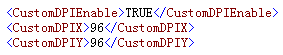
Figure: SuperMap.xml Configuration - Set CustomDPIEnable=true in SuperMap.xml (located in SuperMap iServer installation\support\objectsjava\bin)
- Ensure matching CustomDPIX and CustomDPIY values between desktop and server configurations
- Set CustomDPIEnable=true in SuperMap.xml (located in SuperMap iDesktopX installation bin directory)
- Do not encrypt compact tiles intended for SuperMap iServer publication.
Related Topics