


A drainage basin is one of the ways to describe watershed areas. The Calculate Watershed Basin function is used to create a raster dataset that describes drainage basins.
Feature Description
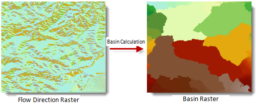
Calculate Watershed Basin is the process of assigning unique basins to each cell based on flow direction data. As shown in the figure below, a drainage basin represents one method of delineating watersheds, displaying all interconnected raster cells within the same basin.
 |
It is generally assumed that all drainage basin outlets are located at raster boundaries, meaning water flows outward beyond these boundaries. Therefore, when calculating watershed basins, the system first identifies individual outlets, then determines watershed divides based on flow directions to establish basin boundaries and ultimately define each drainage basin.
When creating direction rasters, better results can be achieved by using the Force Boundary Cells to Flow Outward parameter. For details about this parameter, see Flow Direction.
Feature Entry
- Spatial Analysis Tab - >Raster Analysis Group -> Hydrology -> Calculate Watershed Basin.
- Toolbox -> Raster Analysis -> Hydrology -> Calculate Watershed Basin.
Parameter Description
- Flow Direction Data: Select the datasource and dataset containing the direction raster.
- Result Data: Set the datasource name and dataset name for storing results.
- Click the Execute button to run the prepared analysis. After the execution is completed, the output window will indicate whether the result was successful or failed.