


Flow direction refers to the direction of water flow on a hydrological surface. Flow direction is one of the key steps in hydrology analysis. Many hydrological functions require direction raster as input, such as calculating cumulative flow accumulation, flow length, and watersheds.
In SuperMap, the eight neighboring grids around the center grid are encoded. The encoding uses powers of 2, starting from the grid directly east of the center grid and proceeding clockwise. The values are 2⁰, 2¹, 2², 2³, 2⁴, 2⁵, 2⁶, 2⁷ respectively (1, 2, 4, 8, 16, 32, 64, 128), representing flow directions to east, southeast, south, southwest, west, northwest, north, and northeast. Each center grid's flow direction is determined by one of these eight values. For example, a westward flow direction is assigned 16, while eastward flow is assigned 1.
 |
| Figure: Flow Direction Schematic |
Feature Description
Boundary Flow Processing
Boundary grids (with fewer than eight possible flow directions) can be specially handled. When specified to flow outward, their direction values follow the left diagram. Otherwise, boundary grids will be assigned no-data values (as shown in the right diagram).
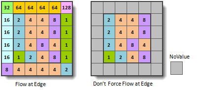 |
| Figure: Boundary Grid Flow Direction |
Elevation Change Gradient Raster
During flow direction calculation, the application uses the steepest descent method. This method determines flow direction by identifying the adjacent grid with the maximum elevation drop ratio (elevation difference divided by distance), known as elevation gradient.
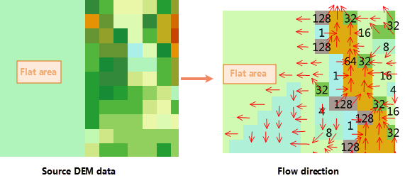
Flat Area Flow Processing
For flat areas with zero elevation gradient, the application performs fill operations to enable outflow. This operation adjusts elevation values based on surrounding areas, then recalculates the steepest descent direction for flow determination.
 |
Feature Entry
- Spatial Analysis Tab - Raster Analysis Group-> Hydrology -> Flow Direction。
- Toolbox -> Raster Analysis -> Hydrology -> Flow Direction。
Parameter Description
- Source Dataset:Specify the datasource and dataset containing the DEM data for flow direction analysis.
- Force the flow direction outwards if it is at edge:When checked, all edge grids will have outward flow directions.
- Create the changing elevation gradient:When selected, the calculation will generate an additional gradient raster showing elevation change rates. Disabled by default.
- Result Data:Set the output datasource, direction raster name, and gradient raster name (available only when elevation gradient option is checked).
- Click Execute to run the analysis. The output window will display execution status (success/failure) upon completion.