


The primary step to implement dynamic segmentation is to obtain route data. Each route has a unique identifier value (Route ID) and measure values (M values). When generating an event table, the route and measure values where events occur (linear events include start and end measure values) need to reference the Route ID and M values in the route dataset.
Generating route dataset creates route data through point data or line dataset with associated measure fields. It also supports feature editing functions for generated route datasets.
Feature Description
SuperMap Desktop provides four methods to generate route datasets: Line Reference Point Measure, Line Single Field, Line Dual Field, and Line Length.
- Line Reference Point Measure: Generates route datasets using line data and reference point data.
The process is as follows: First map reference points to the line dataset through route ID field values, then determine measure values for line data nodes based on reference point measures stored in their property fields.
Based on positional relationships between reference points and line nodes, there are three scenarios:
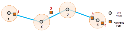
- When reference points coincide with line nodes (within given tolerance), their measure values are directly assigned. Multiple points in tolerance range will use the nearest point's value.
- Points outside tolerance range: If perpendicular distance to line is within tolerance (considered on line), measure values may be used for M value calculation. Otherwise (considered off line), excluded from calculation.
- Lines without reference points within tolerance range will not generate corresponding routes. The object count may differ from original line dataset.
- Line Single Field
Generates route datasets using a single property field storing termination measure values (end node M value). Start node M value defaults to 0, with middle points calculated via interpolation. Object count matches original line dataset.
- Line Dual Field
Uses two property fields storing start and end node measure values. Middle points are calculated via interpolation.
- Line Length
- Uses cumulative line length from start node as measure values. Start node M=0, end node M=line length. Object count matches original line dataset.
Feature Entry
- In Transport Analysis Tab -> Dynamic Segmentation group, click Dynamic Segmentation button -> Generate Route.
- Toolbox -> Transport Analysis -> Dynamic Segmentation tools: Generate Route; or drag the tool to Model Builder window and double-click the feature icon.
Parameter Description
- Generation Method: Four options - Line Reference Point Measure, Line Single Field, Line Dual Field, Line Length. Parameters vary by method. Common parameters described first.
- Source Dataset: Select datasource, dataset and route ID field for line data.
- For Line Single Field: Set termination measure field.
- For Line Dual Field: Set both start and termination measure fields.
- Parameter Settings:
- Measure Offset: Global offset applied to all measures. Example: Node M=0.09 with offset 10 becomes 10.09. Default 0.
- Measure Factor: Unit conversion factor. Example: Convert meters to kilometers using 0.001. Default 1.
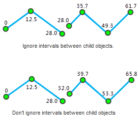
- Ignore Gaps Between Subobjects: Determines measure continuity. When enabled (default), M values remain continuous across gaps. When disabled, gaps add Euclidean distance to subsequent measures.
As shown below: When ignoring gaps, end M of first subobject equals start M of second. When not ignoring, start M of second equals end M of first plus gap distance.
- Reference Point Dataset: Required when using Line Reference Point Measure method.
- Set reference point datasource, dataset, route ID field, measure field, and error field.
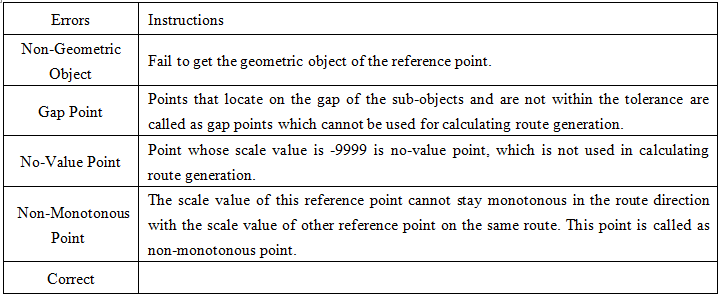
- Error Field: Stores generation errors. Automatically added to reference point dataset's attribute table. See error descriptions below:
- Tolerance: Reference points beyond this tolerance are excluded from calculation. Default tolerance relates to dataset's coordinate system. See Tolerance Specifications.
- Result: Set output datasource and dataset name for route data.
- Click Execute to run the operation.
Route Editing
Supports feature editing operations on route datasets including: line split, polygon split, selected object split, break, precise split, smooth, resample, merge, and connect lines. For details see Editing Objects.
Note: After extending linem objects, users must manually calibrate M values for extended portions based on extended length.