


During the registration process, the application calculates residual errors, RMSE, and total root mean square error for all control points.
Residual Error
Residual error refers to the difference between observed values and regression estimated values. In registration, observed points are control points on the reference layer, which can be pricked points or input X/Y coordinates. Calculated points are fitting points derived from registration layer control points using specific algorithms. Residual errors consist of X and Y components:
- X Residual: The distance between observed and calculated points along the X-axis.
- Y Residual: The distance between observed and calculated points along the Y-axis.
RMSE
For linear and polynomial registration, after selecting ground control points (GCPs), the RMSE (Root Mean Square Error) for each GCP is calculated using the following formula:
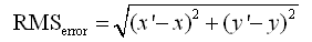 |
Where (x, y) are coordinates of GCPs in the original image, and (x′, y′) are estimated coordinates from first/second-order polynomial calculations. The difference between estimated and original coordinates reflects geometric correction accuracy. Both linear and polynomial registration compute RMSE in X/Y directions. GIS applications typically have an acceptable total RMSE threshold. When individual GCP's RMSE exceeds this threshold, adjusting or removing such points can reduce overall error and improve registration accuracy.
Total RMSE
Total RMSE represents accumulated errors from all registration points, serving as the calibration precision indicator. The Total RMS Error is calculated by:
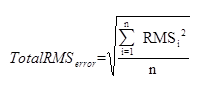 |
Where n is the number of control points, and RMS represents individual point's RMSE. When certain control points' RMSE exceeds acceptable total RMSE, removing or adjusting these points helps maintain overall error within tolerance.
Related Topics