


Feature Description
Weighted sum refers to the process of overlaying multiple raster data into a single raster according to specified weights. It is commonly used in suitability analysis for vegetation and crops, as well as site selection analysis for schools and parks. The calculation principle is: Each raster value is multiplied by its corresponding weight, then the pixel values at the same location are summed to obtain the result data. As shown in the following figure, taking the first pixel in the upper left corner as an example: Raster value 2 * weight 0.7 + Raster value 3 * weight 0.3 = 2.3.
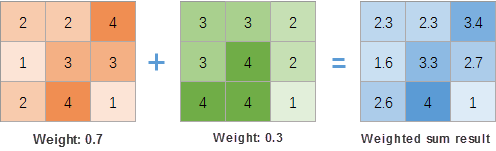 |
| Schematic Diagram of Weighted Sum Principle |
Feature Entry
- Data Tab -> Data Processing -> Raster -> Weighted Sum.
- Toolbox -> Data Processing -> Raster -> Weighted Sum.
Parameter Description
- Add Data: Click the Add button on the toolbar, select input raster data in the Select dialog. Data requirements:
- Input raster data must have the same coordinate system;
- Pixel formats can be floating-point, integer, unsigned, etc., and may vary;
- Weight: Set weight values for raster data. Weights can be positive/negative values, integers, or decimals. Total weights need not equal 1. Example: For crop suitability analysis with 50% sunlight, 20% slope, and 30% aspect influence, set weights as 0.5, 0.2, and 0.3 respectively.
- Pixel Format: Defaults to the first raster's pixel format. 11 formats available including 1-bit, 4-bit, 8-bit, 16-bit, 32-bit, 64-bit, single, and double. Details see Raster Dataset Pixel Formats.
- Compress the Dataset: When checked, the system will compress store the result dataset; otherwise, no compression will be applied.
- Ignore NoValue Cells: When checked, NoValue cells in input raster datasets will be excluded from algebraic operations, leaving corresponding result pixels as null (typically -9999). If unchecked, NoValue cells will be treated as normal values, potentially altering the result dataset's minimum/maximum values.
- Result Data: Set result datasource and dataset.
Application Example
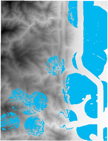
Case Description
Existing data related to park planning site selection factors. Perform park site selection based on the following criteria:
- Terrain: Slope less than 20°;
- Elevation: Values between 1000-1800m;
- Distance to Lakes: Within 1km from lakes;
- Distance to Streets: Candidates should be outside 300m buffers of main streets.
Data Description
Involved data includes: Terrain data, lake data, park data, and road data.
Steps
- Slope: Perform slope analysis on terrain data, then conduct algebraic operations to assign 1 for slopes ≤20° and 0 otherwise. Expression: Con([Slope]<=20, 1, 0).
- Elevation: Perform algebraic operations on terrain data, assigning 1 for elevations between 1000-1800m and 0 otherwise. Expression: Con( ([terrain]>=1000 ) & ([terrain]<=1800 ),1,0).
- Lakes: Set raster analysis environment bounds to terrain data, generate distance raster for lakes, then perform algebraic operations assigning 1 for distances ≤1000m. Expression: Con( [LakesDis] <= 1000,1,0).
- Roads: Generate distance raster for roads, perform algebraic operations assigning 1 for distances ≥300m. Expression: Con( [LakesDis] >= 300,1,0).
- Weighted Sum: Click Data Tab->Data Processing->Weighted Sum, add processed slope, elevation, lake, and road rasters with weights 0.3, 0.25, 0.2, 0.15 respectively.
- Perform raster algebraic operation on weighted sum result: Assign 1 to pixels ≥1 and 0 otherwise. Clip the result with existing parks, retaining only areas outside existing parks. Blue areas in the following figure show suitable locations:
Related Topics