



Feature Description
Auto Generate Polygon is used to quickly fill closed blank areas during map editing, reducing manual digitizing work and improving the efficiency of area object collection and editing.
This feature identifies closed areas based on the boundaries of line and area objects within the current map visible bounds, and creates new area objects in the specified editable area layer. It supports identifying closed areas formed between area objects, between line objects and area objects, and between line objects. Users do not need to manually trace the area boundaries, as gaps between layers, gaps within a layer, or island/hole areas can be generated as area objects.
Application Scenarios
- DLG data production: Different land use types correspond to different layers. After operators complete the drawing of surrounding land use types, closed blank areas can be generated as corresponding land use area objects to complete the data deliverables.
- Natural resources data editing: When area objects such as artificial green spaces, ponds, and woodlands form closed areas with line objects such as road edges, un-drawn land use area objects can be quickly generated to support subsequent attribute assignment and quality checks.
Feature Condition Description
- At least one editable area layer must exist in the Layer Manager.
- The target location must consist of line or area objects within the current map visible bounds that form a recognizable closed area. Non-closed gaps, open areas, or areas whose complete boundaries cannot be identified within the current map visible bounds cannot be used to auto generate polygon objects.
- The generated area object is assigned to the currently specified editable area layer.
Version Information
SuperMap iDesktopX 2026 provides the Auto Generate Polygon feature starting from this version.
Feature Entry
- Edit Data tab > Object Editing group > Polygon Editing drop-down button > Hole Treatment group > Auto Generate Polygon button
- Polygon Editing toolbar > Auto Generate Polygon tool
Operation Instructions
- Select an editable area layer in the Layer Manager as the current editing layer.
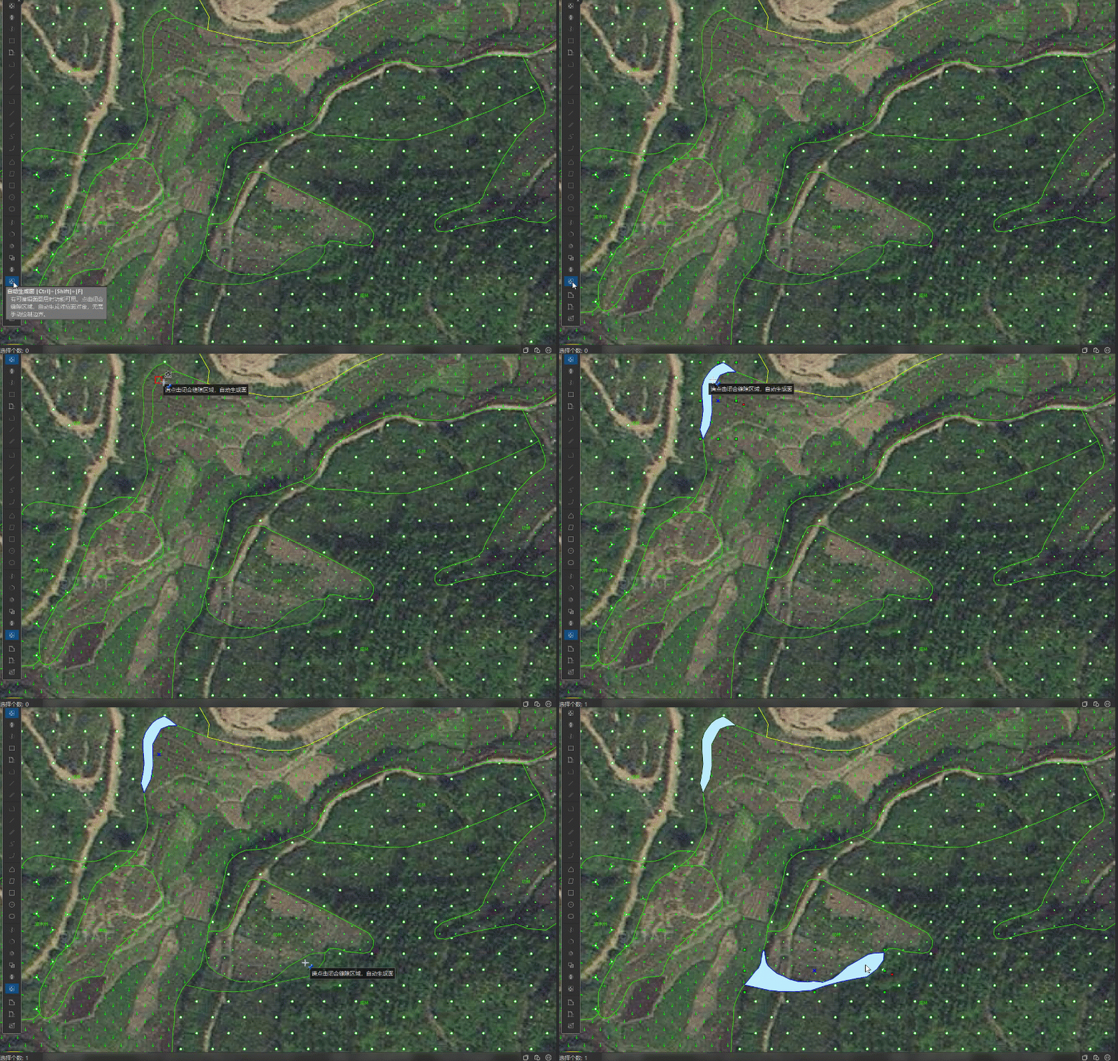
- Click the Auto Generate Polygon button, or press the Ctrl+Shift+F shortcut key to enable the feature.
- In the map, move the mouse to the closed blank area where you want to generate an area object. This area can be formed by boundaries between area objects, between line objects and area objects, or between line objects. After the feature is enabled, the mouse pointer switches to a positioning state and displays the prompt "Please click the closed gap area to auto generate polygon".
- Click the target closed area.
- Closed area: The system automatically generates an area object that matches the closed area boundary and adds it to the current editing layer. After generation is complete, the Output Window displays the message "Auto generate polygon operation successful", and the generated area object is selected by default.
- Non-closed area: The system does not generate an area object, and the Output Window displays the message "Within the current map display range, no closed area is detected at this location, and the automatic generated surface operation cannot be performed."
- To continue generating other area objects, click other closed blank areas; to end the operation, switch to another editing tool or end the current editing state.
 Notes:
- The complete boundary of the target closed area must be within the current map visible bounds or within the range that the system can query. If the gap range is too large or the boundary extends beyond the current map visible bounds, the auto generate polygon operation may not be executable.
- For areas with abnormal shapes, complex boundary relationships, or data errors, it is recommended to correct the data boundaries before performing the auto generate polygon operation.
Related Topics