


Manage LAS datasets includes functions such as browse footprint attributes, add/remove LAS files, build pyramids, and more.
Browse Footprint Dataset Properties
Select the LAS dataset in the datasource list, right-click Browse Footprint Attributes to open the footprint attribute table of the LAS dataset. Each record represents a footprint, corresponding to the point cloud boundary of a LAS file. A single footprint record includes extent and metadata. The main fields in the attribute table are:
- File path (FilePath): The full path (absolute path) of all LAS files added to the LAS dataset for management.
- Creation software (GenerateSoftware): This field represents the generation software package and its version used during the creation of LAS files.
- Date created (CreateTime): This field represents the creation date of LAS files.
- Version number (LasVersion): This field represents the version of LAS files.
- Point format (PointFormat): This field represents the type of point data records in LAS files.
- Point record length (PointRecordLength): This field represents the byte length of point data records. All point data records within a single LAS file must be of the same type, hence their lengths are identical.
- Point count (PointNumber): This field represents the number of point clouds in LAS files.
- Maximum (MaxZ): This field represents the maximum elevation value of LAS files.
- Minimum elevation (MinZ): This field represents the minimum elevation value of LAS files.
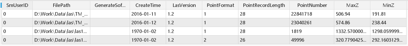 |
| Figure: Attribute Table |
Manage Files
After creating the LAS dataset, you can still add or delete files in the dataset.
Function Entrance
Right-click the LAS dataset in the datasource list, select Manage LASDataset->Manage files. In the dialog box that appears, you can add or delete LAS files. In the toolbar area, an add file tool button is provided, allowing addition via single files or folders.
Build Pyramids
Building pyramids for LAS datasets can improve the rendering and display efficiency of massive point cloud data.
Function Entrance
Right-click the LAS dataset in the datasource list, select Manage LAS datasets->Build pyramids.
After creation is complete, the program will prompt that the pyramid was built successfully, and automatically create a pyramid results folder under the storage path of LAS files, with the default folder name being datasource name_dataset name. This folder contains pyramid index files, with the default naming format [datasource name_dataset name].db.
Delete Pyramid
After re-editing the LAS dataset, the previously built pyramids have not changed. At this time, you need to delete the previous pyramids and rebuild the pyramid.
Function Entrance
Right-click the mosaic dataset in the datasource list, select Manage LAS datasets>Delete Pyramid.
After deletion is complete, the program will prompt that the delete pyramid operation was successful, and synchronously delete the pyramid folder.
Related Topics