


Feature Description
SuperMap uses LAS datasets to manage LAS files. The LAS dataset is a data structure designed for efficient management and access of LiDAR data, employing a lightweight metadata management mechanism to organize massive point cloud data efficiently through file path indexing. It is suitable for application scenarios such as smart city real-world 3D modeling, power line inspection, and geological disaster monitoring that require processing TB-level point cloud data, achieving an optimal balance between source data integrity and data processing efficiency.
Before creating a LAS dataset, note the following usage conditions:
- Supported File Versions: Supports standard *.las files, versions 1.0 to 1.4.
- Supported File Storage Paths: Supports locally stored LAS files.
- Supported Data Sources: Supports UDBX and PostGIS data sources.
Function Entry
- Start tab->New Dataset dropdown->3D->LAS.
- Workspace Manager->Data source Context Menu->New Dataset->LAS.
Operation Instructions
- Right-click on the data source, select New Dataset->LAS from the context menu. The Add File dialog box will pop up (you can choose to add files here or cancel to create an empty LAS dataset directly, and add files later via Manage LAS Dataset).
- In the Add File dialog, use the toolbar tools to add or delete LAS files. The LAS dataset records the absolute path information of added files.
- Add: The dropdown button includes the following options:
- Add File: Add specified LAS files to the current list area.
- Add Folder: Add all LAS files in the specified folder.
- Delete: Only removes files from the current list that should not be added to the LAS dataset.
- The file list area displays basic information of added LAS files, including:
- Name: Displays the name of the LAS files.
- Path: Displays the disk path of the LAS files.
- Version: Displays the version of the LAS files.
- Point Count: Displays the number of point clouds in the LAS files.
- Z Min: Displays the minimum elevation value of the LAS files.
- Z Max: Displays the maximum elevation value of the LAS files.
- Add: The dropdown button includes the following options:
- Set the data source for storing the LAS dataset and the dataset name.
- Set the target coordinate system. After adding LAS files, the software sets the coordinate system of the first file containing one as the LAS dataset's coordinate system. You can also set the coordinate system via the coordinate system settings toolbar using Reset Coordinate System, Copy Coordinate System, or Import Coordinate System. For LAS dataset coordinate system settings, refer to View Image Projection.
- After successful creation, one outline sub-dataset will be generated, which is a vector region dataset. Each record represents an outline corresponding to a LAS file's point cloud boundary, containing extent and metadata information.
-
Default fields include: file path (FilePath), creation software (GenerateSoftware), date created (CreateTime), version number (LasVersion), point format (PointFormat), point record length (PointRecordLength, in bytes), point count (PointNumber), maximum (MaxZ)/minimum elevation (MinZ), as shown below.
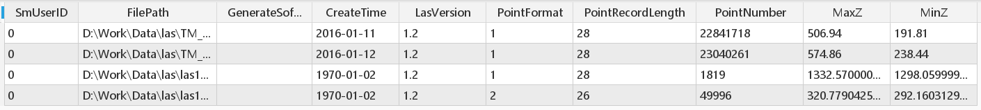
Figure: Outline Dataset Properties Table
-
Related Topics