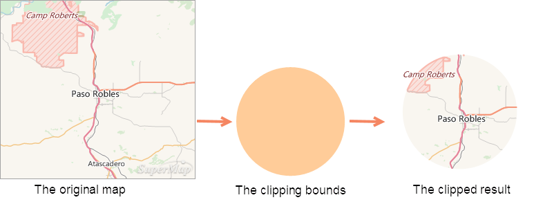
When performing geographic Data Processing and analysis, you may only need to study a certain area in the map. In this case, you can extract the map or data of the area through the Map Clipping function. Clipping also reduces the amount of data and improves the efficiency of Data Processing.
When there are one or more layers in the Map, the Clip Layer can be clipped by Draw Rectangle, circle, polygon or selecting a face object in a layer. Crop results can be output as New Dataset. The Clip Layer can be a point, line, surface, CAD layer, text layer, or Raster Layer; the Clip Bounds must be a surface layer. The type of the clipping result is finally consistent with the Clip Layer.
 |
| Figure: Schematic Diagram of Map Clipping |
Clip Mode
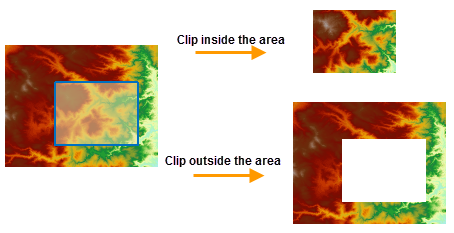
When performing Map Clipping, you can set the clipping mode, including outside the area and inside the area:
- Within the region: The map within the clipping region will be kept for output.
- Outside the area: The map outside the clipping area will be kept and output.
 |
| Figure: Schematic diagram of clipping area |
Erase Clip Area
The operation of Erase Clip Area on the Clip Layer. After the operation, part of the data in the clipped area of the Clip Layer will be erased. Currently, only Erase Clip Area operations can be performed on map data in vector format, and raster maps do not support erasure operations.
As shown in the figure below: The yellow area is the Clip Layer, and the green area is the Clip Layer. Select the circular area to perform Map Clipping on the green polygon. The Clip Mode is within the area. After the Map Clipping is completed, the result of erasing the Clip Layer is as follows:
 |
| Figure: Erase Clip Area Diagram |
Exact Clip
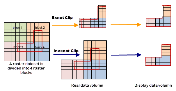
When cropping the grid or Image Data, you can select whether to perform an Exact Clip in the Exact Clip drop-down box. The difference between the Exact Clip and the default clip is (for example, Inside Clip):

- The amount of Raster Data for obtaining the clipping result is different, and the main difference is the processing of the clipping area Bounds Data:
- Exact Clip: The Data Processing cell at the boundary of the clipping area is a pixel. If the clipping area covers the center point of the pixel, the pixel is retained. Otherwise, it is not reserved. As shown in Figure 1 below, the pixels with the center point in the clipping area are retained, and the pixels with the center point outside the clipping area are discarded to obtain the final actual storage data with a small amount of data.
- Default Crop : The Data Processing cell at the boundary of the crop area is a grid block. If the crop area intersects the grid block, the entire grid block is retained. As shown in Figure 2 below, if the grid block size is 256 * 256, and the clipping area intersects with grid block 2, grid block 3, and grid block 4, the three grid blocks are all reserved, and the final actual storage data is obtained, and the amount of data is relatively large
- The reason for different Display Effects is that the amount of Raster Data used to obtain the clipping results is different ( Display Effects displays the actual stored data obtained by clipping according to the clipping area):
- Exact Clip : Due to the selection of the boundary pixels of Result Data clipping, the display result will have the situation that the reserved part is less than one pixel and the discarded part is a little blank, as shown in Figure 3 above.
- Default clipping : Since the Result Data retains the entire grid block intersected with the boundary, the display result is displayed strictly according to the clipping area, as shown in Figure 4 above.
- Cutting efficiency is different: The processing unit of the
default clipping boundary area is the grid block, and the processing unit of the Exact Clip boundary area is the pixel. Therefore, the efficiency of the default clipping is higher than that of the Exact Clip. When large data is clipped and only Display Effects is concerned, the default clipping is preferred. Exact Clip is used when more accurate actual storage data is required.
Related topics


