


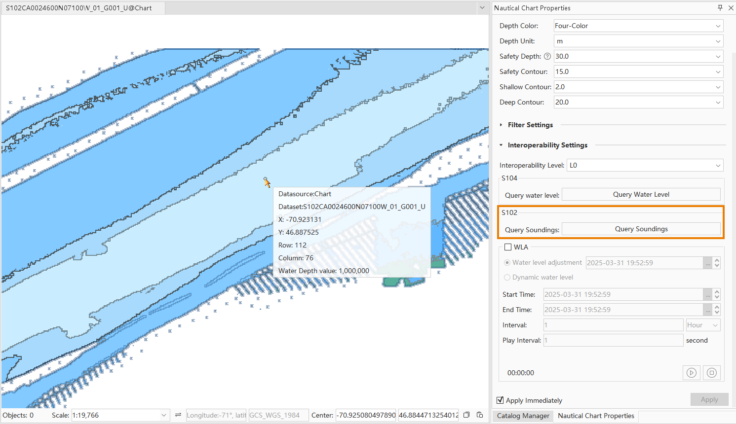
In the Interoperability Settings group of the Nautical Chart Properties panel, display content compliant with the S-98 interoperability standard is organized. This includes interoperability level, S-104 query water level, S-102 query soundings, water level adjustment, and dynamic water level.
S-98 Product Interoperability
S-98 refers to the "Data Product Interoperability in S-100 Navigation Systems" developed by the International Hydrographic Organization (IHO), abbreviated as S-98 product interoperability.
The purpose of this specification is to ensure that different S-100-based data products can work seamlessly together in Electronic Chart Display and Information Systems (ECDIS) as well as other shipboard and shore-based systems.
By defining an Interoperability Catalogue, the S-98 specification provides rules and structures to guide the concurrent use and display of multiple S-100 data products, ensuring interoperability between different data layers and delivering a comprehensive, coordinated navigation information environment.
Interoperability Level
Provides L0 and L1 interoperability level settings. When S-57, CJ-57, and S-101 chart products coexist, they will be displayed according to their respective product specifications.
- L0: Map display is affected by layer order in the Layer Manager, where upper layers override lower layers.
- L1: When multi-standard data exists in the map, data will be displayed according to S-98 product interoperability standards, unaffected by layer positions.
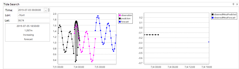
S-104 Query Water Level
After clicking the Water Level Query button, a Tide Search window will appear below the map. Select a hydrological station on the map with the mouse, and its information will be displayed in the Tide Search window.
- Current time: Defaults to the initial recording time of the selected hydrological station. Adjust using the settings button or direct input, with corresponding updates in the trend chart.
- Query conditions: Defaults to Next 7 days, showing water level changes for the upcoming week. Options include: Next 3 hours, 6 hours, 12 hours, 1 day, 3 days, 5 days, and All future periods.
- Display data points: Toggle to show/hide data points in the trend chart.
- Display legend: Toggle to show/hide legend information beside the trend chart.
S-102 Query Soundings
After clicking Query Soundings, move the cursor over the map. Data information at the cursor position will be displayed, including: datasource, dataset, X coordinate, Y coordinate, row, column, and depth value.
Water Level Adjustment
Open S-102 and S-104 data in the current map and check the WLA group checkbox. S-102 data will be adjusted and displayed based on S-104 water level data, determined by the time set in Water Level Adjustment.
Dynamic Water Level
Open S-102 and S-104 data in the current map, then check both WLA group checkbox and Dynamic Water Level. S-102 data will adjust and display according to S-104 parameters: start time, end time, interval, and playback interval. Use the play button to observe temporal changes in S-102 bathymetric surfaces.
- Start time: Initial time for dynamic S-102 display, configurable via S-104 attributes.
- End time: Termination time for dynamic S-102 display, configurable via S-104 attributes.
- Interval: Time interval for S-102 adjustments (default: 1 Hour). Units available: Second, Minute, Day.
- Playback interval: Duration for each interval change during playback (default: 1 second).
Related Topics
S-104 Navigational Water Level