


Create Editable Chart Group
Feature Description
To produce a new chart, you need to create a new editable chart dataset group. After successful creation, the corresponding dataset group will only contain the information entered during creation.
Steps
Taking the creation of a CN5X0000 chart dataset group in the Chart datasource as an example, the specific steps to create a chart group are as follows:
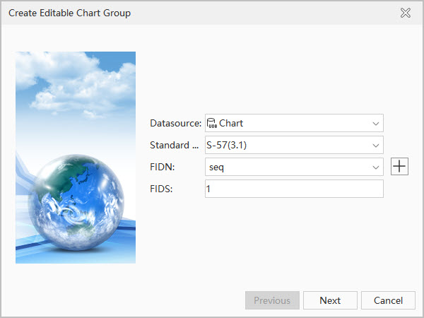
- In the Workspace Manager, right-click the Chart datasource node, select New Dataset... -> Editable Chart Group..., or click the Chart tab -> Chart Data Management group -> New. The Create Editable Chart Group dialog box will appear. Set the following information in the dialog:
- Datasource: Click the drop-down button on the right and select Chart as the datasource for storing the chart dataset group.
- Data Standard: Default is S-57(3.1), which is the 3.1 version released by IHO in November 2000 and is the current valid S-57 standard. If needed, the standard can be switched to CJ-57(JTS 195-3-2019), i.e., the "Inland Electronic Chart Technical Specification" released by the Ministry of Transport in August 2019, with standard code JTS 195-3-2019; or IENC (2.4), the International Inland Electronic Navigational Chart specification.
- Signature Sequence: Specify the FIDN for the data group. When a feature object is created, the corresponding FOID is also created and assigned to the feature object. Click the drop-down button on the right to select a signature sequence. If no signature sequence has been created before creating the editable chart group, click the
 button in the dialog to Create Signature Sequence.
 - Feature Identification Division Number: That is FIDS, an important part of the Feature Object Identifier (FOID). Here, you can assign a feature identification division number to the created chart dataset group, set it to 1, with a value range of 1~65534.
Create Editable Chart Group: Step 1 - After completing the parameters in the first step, click Next to set the layer bounds. In the Left, Bottom, Right, and Top text boxes, input the longitude and latitude of the top-left and bottom-right points of the range, for example: Left: 120°, Bottom: 31.8°, Right: 120.5°, Top: 32°.

Create Editable Chart Group: Step 2 - After completing the range settings in the second step, click the Next button. In the pop-up dialog, set the following parameters:
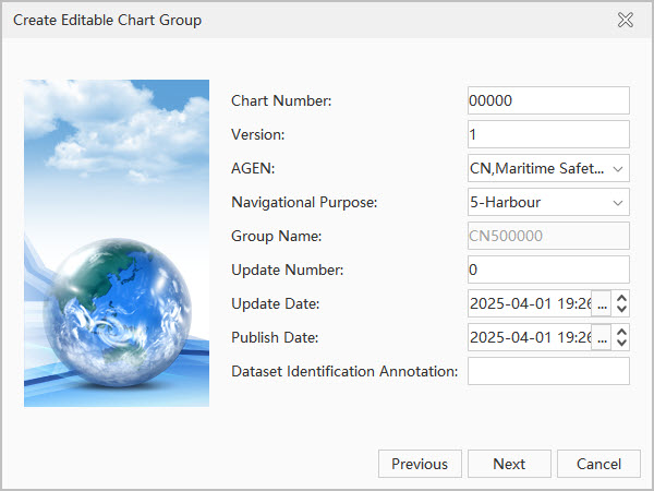
Create Editable Chart Group: Step 3 - Chart Number: This is one of the important components of the group name and can be set to any five ASCII characters such as letters or numbers. Set the Chart Number to X0000 here.
- Version Number: When an S-57 file (000 file) is initially generated, the version number is set to 1. The version number increases by 1 with each new version. Set the Version Number to 1 here.
- Producing Agency: The agency that produces the chart data. Specific producing agency codes can be found in the IHO Producing Agency Code Table. For example, the agency code for China Maritime Safety Administration is CN.
- Navigational Purpose: The purpose and classification of electronic charts are determined based on ship navigation, waterway maintenance, and production needs. Electronic charts under different standards have different classifications for purpose types. The following are the classifications and scale ranges under the S-57 and CJ-57 standards:
- The S-57 standard divides electronic charts into six navigational purposes. The specific classifications and scale ranges are as follows:
ID Navigational Purpose Scale Range Available Editing Scales (1:) 1 Overview ≤1:1,500,000 >3,000,000, 1,500,000 2 General 1:350,000~1:1,490,000 700,000, 350,000 3 Coastal 1:90,000~1:349,000 180,000, 90,000 4 Approach 1:22,000~1:89,000 45,000, 22,000 5 Harbour 1:4,000~1:21,999 12,000, 8,000, 4,000 6 Berthing >1:4,000 <3,999 -
CJ-57 Inland Electronic Navigational Charts include 10 navigational purposes such as Water Area Overview Chart, Waterway Overview Chart, and Inland Waterway Chart. The specific classification principles can be referred to in the table below:
ID Navigational Purpose Scale Range Available Editing Scales (1:) 1 Water Area Overview Chart 1:200,000 >3,000,000, 1,500,000 2 Waterway Overview Chart 1:50,000~1:200,000 700,000, 350,000 3 Coastal 1:90,000~1:349,000 180,000, 90,000 4 Approach 1:22,000~1:89,000 45,000, 22,000 5 Harbour 1:4,000~1:21,999 12,000, 8,000, 4,000 6 Berthing >1:4,000 <3,999 7 Inland Waterway Chart 1:2,000~1:50,000 8 Inland Harbour Chart 1:2,000~1:10,000 9 Inland Berthing Chart 1:1,000~1:5,000 A Overlay Chart Adapts to the scale of the overlaid chart
- The S-57 standard divides electronic charts into six navigational purposes. The specific classifications and scale ranges are as follows:
- Group Name: Used to display the filename of the S-57 file (000 file) corresponding to this chart. The chart dataset group name is composed of "Producing Agency Code + Navigational Purpose + Chart Number", for example, "CN5X0000" has a producing agency code of CN, a navigational purpose of 5-Harbour, and a chart number of X0000.
- Update Number: The update number for a new S-57 file (000 file) is set to 1. The update number for the first update file related to the new S-57 file is 2. The update number increases by 1 with each consecutive update and can be modified according to the version number of the electronic chart to be produced.
- Update Date: Updates to the S-57 file data must be made on or before this date. Click the drop-down button on the right and select the update date in the date panel.
- Issue Date: This is the date when the data producer makes the data available. Click the drop-down button on the right and select the issue date in the date panel.
- Dataset Identification Comment: You can input the comment information for the dataset identification here. This text box can only input ASCII characters, such as letters and numbers. For example, input the dataset group creation date "20240131" as the comment information.
- After completing the parameters in step 3, click the Next button to set parameters in the pop-up dialog.
Create Editable Chart Group: Step 4 The introduction and settings of various parameters in the dialog are as follows:
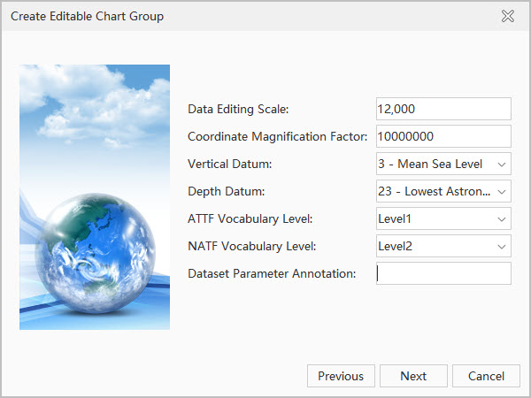
- Editing Scale: Refers to the denominator value of the scale used when producing this chart data. If the navigational purpose set in step 3 is Harbour, the available editing scale is 1:12,000. Set the editing scale to 12000.
- Coordinate Multiplication Factor: Refers to the multiplier factor used to convert coordinate values from floating-point to integer. Keep the default setting.
- Vertical Datum: Refers to the reference surface from which various elevations on the chart are calculated. The application provides 31 selectable datums. Users can choose based on the datum to which the current chart data belongs. Select the "3-Mean Sea Level" datum here.
- Depth Datum: Refers to the reference surface from which water depths on the chart are calculated. The application provides 31 selectable datums. Users can choose based on the datum to which the current chart data belongs. Select the "23-Lowest Astronomical Tide" datum here.
- ATTF Vocabulary Level: Refers to the character level used for the attribute values of the feature record attribute field (ATTF). The S-57 standard specifies that the ATTF vocabulary level should be level 0 or level 1. Level 0 is ASCII text, and level 1 is ISO 8859 Part 1, Latin Alphabet No. 1 series. Level 1 character set can be directly used on almost all computer systems. Click the drop-down button on the right and select Level1.
- NATF Vocabulary Level: Refers to the character level used for the attribute values of the feature record national attribute field (NATF). The S-57 standard allows the use of three vocabulary levels for NATF: 0, 1, and 2. Levels 0 and 1 are consistent with the definition of ATTF. Level 2 is the Universal Character Set, which includes almost all languages, including Latin characters, Greek, Chinese, Japanese, etc. Click the drop-down button on the right and select Level2.
- Dataset Parameter Comment: You can input the comment information for the dataset parameters here. This text box can only input ASCII characters, such as letters and numbers. For example, input the chart data location name as the parameter comment: huangpujiang.
- After completing the parameters in step 4, click the Next button. In the pop-up dialog, you can review all parameters set for the dataset group in the previous four steps.
- Click the Done button to complete the creation of the editable chart dataset group named CN5X0000. The group will by default create three datasets corresponding to the essential meta objects for ENC electronic charts (M_COVR, M_NSYS, M_QUAL): Coverage Area, Navigational Aids, and Data Quality datasets.
Related Topics