


Feature Description
The "3D Hillshade" function determines illumination values for each cell in a raster surface to create hypothetical shading effects. By setting the position of the hypothetical light source and calculating illumination values for each cell, it generates visualized terrain relief. When performing analysis or graphic display, especially when using transparency, the 3D shaded relief can significantly enhance the 3D display effects of raster surfaces. For detailed information about 3D Hillshade, please refer to 3D Hillshade.
Application Example
Open the "Terrain" datasource in the "ExerciseData/RasterAnalysis" folder, which contains DEM data with 5-meter resolution. We will use this data for demonstration.
Feature Entry
- Spatial Analysis Tab -> Raster Analysis -> Surface Analysis -> 3D Hillshade;
- Toolbox -> Raster Analysis Tools -> Surface Analysis -> Terrain Calculation -> 3D Hillshade.
Parameter Description
- Azimuth: The sun azimuth angle in degrees (0-360), measured clockwise from due north.
- Altitude: The sun elevation angle above the horizon. Expressed in positive degrees (0°=horizon, 90°=directly overhead).
- Shadow Model: Three types of 3D hillshade effects are available:
- Shading and Shadow: Considers both local illumination angles and shadow effects.
- Shadow: Only considers whether areas are in shadow.
- Illumination: Only considers local illumination angles.
- Z Factor: A scaling factor for adjusting elevation units relative to X/Y coordinates. Default is 1 (no scaling). Required when elevation units differ from planar units.
- When X/Y units match Z units, keep Z Factor as 1.
- When units differ (e.g., X/Y in meters vs Z in feet), use appropriate conversion (e.g., 0.3048 for feet-to-meters).
Result Data
- Datasources: Lists all datasources in current workspace. Select target datasource (defaults to source datasource).
- Dataset: Specifies output dataset name. The generated hillshade dataset matches the source dataset's extent and resolution.
Click "Execute" to generate the hillshade map.
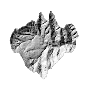 |
| Figure: 3D Hillshade |
Related Topics