Feature Description
Knowledge graphs use entities and relationships to express knowledge. Extracting knowledge (entities and relationships) is a crucial step in graph construction. Generally, structured/semi-structured/unstructured data related to business needs to be collected first, then structured knowledge is extracted through knowledge extraction processes.
SuperMap iDesktopX provides knowledge extraction tools including: creating entities from structured data (tables/feature datasets), and building relationships based on spatial relationships and property field matching.
When needing to build both entities and relationships simultaneously, two approaches are provided based on practical scenarios:
1. Use Create Entity and Build Relationship tools separately. For tool chaining details, see Build Relationship.
2. Use the integrated Build Entities and Relationships tool. Recommended when: the data for building entities is spatial data with large volume. Storing both spatial data and graph data in Yukon database before using this tool can improve performance. When creating entities, check "contains source spatial objects".
Feature Entry
- Knowledge Graph Tab->Build->Create Entity.
- Toolbox->Knowledge Graph->Create Entity.
Parameter Description
- Connect Graph Database: Configure graph database connection information including database type, address, username, password. Click "Join" after completion.
- Entity Type Name: Specify a new entity type name or select existing.
- Datasources: Set datasource name for building entity type.
- Dataset: Set dataset name for building entity type. Supports attribute tables, 2D point/line/region, 3D point/line/region types.
- Label Field: Set display label field for graph nodes. As shown:

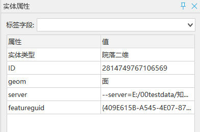
- Contains spatial objects: Whether to load spatial attributes into entities and write to graph database. When checked, entity attribute table will add geom field (shown below) with values as point/line/area/3D point/3D line/3D area. Recommended for spatial data to enable relationship building using spatial relationships.

- Entity fields and entity merge identifier: Configure entity attribute fields and merge identification field. When selected attribute fields serve as identifiers, entities with identical field values can be merged to avoid duplicates. One or multiple identification fields can be set to determine entity uniqueness. Example: For two person entities with same name, additional fields like age should be selected for joint identification.


