


Instructions for use
When you set a point Layer Style or make a Custom Thematic Map based on a Point Dataset, you can set the Rotation angle of the point symbol. The Point Match Line Direction function can calculate the perpendicular line angle and distance from the point to the nearest line object, and the Calculate Result will record the angle, distance, adjacent line ID and other information in the point Dataset Properties table. And generates a Custom Thematic Map based on the Point Dataset according to the specified point style and Rotation angle.
The results recorded in the point Dataset Properties table are described as follows:
- Adjacent Line ID (Line Dataset Name _ ID): ID of the nearest line object;
- Distance: indicates the distance from the point object to the nearest line object, and the unit is consistent with the Dataset unit;
- Vertical Point Coordinate (ProjectPoint _ X, ProjectPoin _ Y): indicates the X and Y coordinates of the vertical point.
- SegmentIndex: indicates the index value of the adjacent segment;
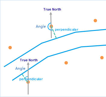
- Angle: indicates the angle between the perpendicular line from the point object to the nearest line object and the north direction, and the Rotation angle of the point symbol pointing vertically to the line;
Principles of Computation
The angle calculation principle is: the included angle between the perpendicular line from the point object to the nearest line and the north direction (counterclockwise), as shown in the following figure:
 |
Application scenario
- The auxiliary point symbol of the hydropower station shall point to the hydropower station, and the auxiliary point symbol shall point to the hydropower station by configuring the Custom Thematic Map through the Point Match Line Direction.
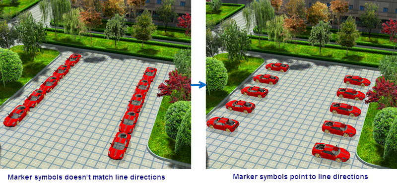
- In 3D Scene, you can adjust the Rotation angle of the car symbol through the Calculate Result of Point Match Line Direction to make the parking directions of cars on the same side of the parking lot consistent.
Function entrance
- Thematic Map-> Custom-> Point Match Line Direction;
- Map-> Drawing-> Point Match Line Direction;
- Data Processing-> Map Cartography-> Point Match Line Direction;
Parameter Description
- Point Dataset: Set a Point Dataset to rotate the direction of the point symbol according to the line data.
- Reference Line Dataset: Set the reference line data of the point data. Note: The coordinate system of the Line Dataset needs to be consistent with the Point Dataset.
- Point Style: Click the point symbol button on the right, and in the pop-up Marker Symbol Selector dialog box, set the point symbol and its style to be used in the Custom Thematic Map. See the Marker Symbol Selector page for detailed instructions. Click Default to restore the point style to the default style.
- Max Distance: If the vertical distance from the point to the nearest line is greater than this value, the point will not be involved in the calculation.
The result of Point Match Line Direction is as shown in the following figure. When the point symbols on both sides of the line object are rotated according to the calculated angle, the point symbol direction points to the line.
 |
 Related topics
 Create a new Custom Thematic Map.