


Instructions for use
Linkage is an important feature of Dynamic Segmentation. After the Generate Spatial Data, a Dynamic Segmentation relationship is established between the Route Dataset used for Generate Spatial Data, the event table, and the generated Spatial Data. Because of the existence of this relationship, when one of the three is modified, the other two will automatically change accordingly according to the agreement. The linkage of Dynamic Segmentation provides convenience for modifying event table and Spatial Data. For more information on Dynamic Segmentation relationship linkages, see the Dynamic Segmentation Relationship Overview .
The dynamic linkage among the three can be divided into the following situations:
- When the Description of the event table changes, linkage occurs between the event table and Spatial Data.
Modifying the Description of the event table refers to modifying the general fields except the route identification field and the scale field, such as the temporary closure of part of the highway due to weather, construction and other reasons. When the Description in the event table is modified, the Attributes of the Spatial Data generated by the table will also be modified automatically. Similarly, when the general Property Field in the Spatial Data attribute table is modified, the information in the corresponding event table will also change dynamically.
- Dynamic changes between the event table and Spatial Data occur when the routing location where the event occurs changes.
Modifying the location where the event occurs refers to modifying the scale value field in the event table or Spatial Data. If the scale value of a record (event) in the event table is modified, the Geometry Info of the point or line object corresponding to the event in the corresponding Spatial Data and the scale field of the corresponding record in the attribute table will also be modified accordingly; If the value of the scale field in the property table of the generated Spatial Data is modified, the Geometry Info of the corresponding object will also change, and the value of the scale field of the associated event in the event table will also change dynamically.
For line events, you can change the start scale or the end scale. The length and position of the event change. As shown in Figure 1, after Generate Spatial Data, modify the start scale and end scale of the first event in the corresponding event table from (20.78, 79.37) to (150.00, 180.00). After modification, the position of the corresponding line in Spatial Data changes. It can be seen that when the scale value of the event changes, the corresponding Spatial Data will also be automatically modified.
of an Event in the Event Table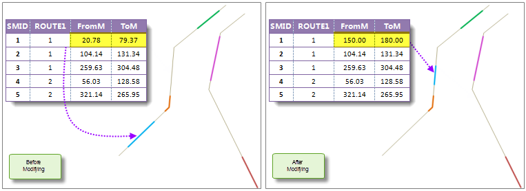
Figure 1: Modifying the Scale Value Note: If there is no intersection between the modified scale value and the M value range of the corresponding route, for example, the modified start scale and end scale are 26 and 60 respectively, while the M value range of the corresponding route is 3 to 20, The Geometry Info of the corresponding location of the Spatial Data does not change. If a part of the modified line event is located on the route, when the termination scale is less than maximum scale of the route, the corresponding Spatial Data will automatically modify the data of the corresponding part. On the contrary, when the termination scale is greater than maximum scale of the route, Failed to modify.
When the route of the event changes, the Spatial Data will change according to the modification of the Route Dataset, while the corresponding Route Data will not change when the Spatial Data is modified; Linked modification occurs between event table and Spatial Data.
This situation is applicable to the situation that the route of the event change needs to be modified due to data error or change, which can be divided into the following situations:
- If the routing ID of a record in the event table is
- modified, the Geometry Info of the associated object in Spatial Data and the routing ID field in the attribute table will also change dynamically. As shown in Figure 2, after the route ID of the first record in the event table is changed from 1 to 2, the Spatial Data corresponding to the record also changes and is located on the route with ID 2. If the route ID of Spatial Data is
- modified, the route ID value of the corresponding record in the event table will also change. At the same time, the Geometry Info of Spatial Data will also change accordingly. of an Event in the Event Table
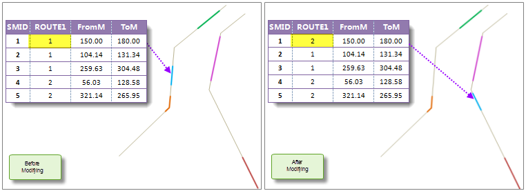
Figure 2: Modifying the Route ID
Operation steps
- In the Dynamic Segmentation Relationship Management "dialog box, select a Dynamic Segmentation relationship and double-click it to pop up a linkage window, as shown in the following figure. Or click the Edit button in the Dynamic Segmentation Relationship Management window to edit the selected Dynamic Segmentation relationship. See the Dynamic SegmentationRelationship Management for the Dynamic Segmentation Relationship Management function.
- The linkage window displays Route Data and Spatial Data. Modify the event table, Spatial Data or Route Data. Link Dara will change according to the situation described in Instructions for use and can be displayed in this window in real time.
- When you are finished, click the Close button to exit Current Windows.
 |
| Figure 3: Dynamic Segmentation Relationship Linkage Window |