


The first step in implementing Dynamic Segmentation is to obtain Route Data. Each route has a Unique identifier value (route ID) and a scale value (M value). When Generate Event Table, refer to the route ID and M value in the Route Dataset for the route and scale value of the event (the line event contains the start and end scale values).
Route Dataset is generated by associating the point data or Line Dataset with the scale field. It also supports the function of Object Editing on the generated Route Dataset.
Instructions for use
SuperMap desktop provides four ways to generate Route Dataset, namely Line Reference Point Measure, Line Single Field, Line Dual Field and Line Length.
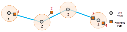
- Line Reference Point Measure: Generate a Route Dataset based on line data and reference point data. The process of Generate Route in
this way is as follows: first, the reference point is mapped to the Line Dataset through the field value of the route identifier, and then the scale value of the Line Data Node is determined according to the scale value of the reference point, so as to obtain the Route Dataset. The reference point's scale value is stored in its Property Field.
According to the position relationship between the reference point and the node in the line data, it can be divided into the following three situations:
- The
- reference point is coincident with a node of the Line Dataset, or within a given tolerance, the scale value of the reference point is assigned directly to the node. When there are multiple reference points in the Fuzzy range, the scale value of the nearest reference point is taken.
- The reference point is not within the Fuzzy range of the Online Data set. If the vertical distance from the reference point to the corresponding arc segment is less than tolerance, it is considered to be "on the line", and the scale value of the reference point may be used to calculate the M value of the node; if the vertical distance is greater than tolerance, it is considered to be "not on the line", and it will not participate in the calculation of the M value of the node. There is no reference point around the
- line data that can be used for the calculation, that is, there is no reference point within the tolerance of the node, and the reference point is not on the Online Data set. In this case, the line object does not generate a corresponding route. The number of objects of Route Data generated in this way may be different from that of the original Line Dataset.
- Line Single Field
Mode
This mode generates a Route Dataset according to a Property Field of line data. This field records a scale value, which will be used as the termination scale value of the corresponding route (that is, the M value of the last node of a route). The starting scale value (M value of the first node) of the route is 0. If there is a Middle Point, its scale value is obtained by interpolation calculation. The number of objects of the Route Dataset generated in this way is the same as that of the original Line Dataset. - Line Dual Field
Mode
This mode generates a Route Dataset based on two Property Fields of line data. These two Property Fields store the scale values as the scale value of the start node and the scale value of the end node of the route, respectively. The scale value of Middle Point is calculated by interpolation. - Line Length Mode
- This mode takes the length along the line from the node of the line object to the start node as the scale value of each node, thus generating the Route Dataset. Obviously, in the Route Dataset obtained in this way, the scale value of the starting node of each route is 0, and the scale value of the ending node is the length of the line. The number of objects of the Route Dataset generated in this way is the same as that of the original Line Dataset.
Function entrance
- In the Traffic Analysis tab-> Dynamic Segmentation group, click the Dynamic Segmentation button and click the Generate Route button in the drop-down menu.
- Toolbox-> Traffic Analysis-> Dynamic Segmentation tool: Generate Route; or drag the tool to the Model Builder Window and double-click the function graph.
Parameter Description
- Generation Method: Application provides four Generation Methods. Line Reference Point Measure, Line Single Field, Line Dual Field, and Line Length. Due to different Generation Methods, the parameters that need to be set when creating a route are different. The same parameters are described below.
- Source data: Select the Datasource, Dataset, and Route ID fields where the line data for Generate Route data is located.
- When the
- Generation Method is Line Single Field, the ending scale field needs to be set as well. When the
- Generation Method is Line Dual Field, the start scale field and the end scale field also need to be set.
- Parameter Settings:
- Scale Offset: The scale offset of the route. After the scale offset is set, all scales on the route will be offset as a whole. For example, if the scale value of a node of a LineM is 0.09 and the set scale offset is 10, the scale value of the node in the generated Route Dataset is 10.09. The default value is 0, that is, no offset is applied.
- Scale factor: The unit conversion used for the scale value. When the unit of the existing scale value is inconsistent with the actual demand, the unit can be converted by the scale factor. For example, to convert scale values from meters to kilometers, the Scaling factor should be set to 0.001. The default value is 1, that is, no unit conversion is performed.
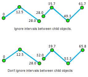
- Ignore spacing between sub-objects: Sets whether to Ignore Intervals Between Subobjects. Default Ignore Intervals Between Subobjects. Routes can be complex objects that contain multiple child objects. A gap occurs when two sub-objects are not contiguous. Whether the sub-object interval is ignored or not affects the continuity of the routing scale value. If the sub-object interval is ignored, the scale value will be continuous, otherwise it will be discontinuous. In this case, the distance between the sub-object intervals is the Straight-line Distance between the two endpoints.
As shown in the following figure, when the sub-object interval is ignored, the M value of the end point of the first sub-object is the same as the M value of the start point of the second sub-object; When the sub-object interval is not ignored, the M value of the start point of the second sub-object is the M value of the end point of the first sub-object plus the Straight-line Distance between them.
- Reference Point Dataset: When the Generation Method is Line Reference Point Measure, according to the previous introduction, The Line Reference Point Measure is based on line data and reference point data to generate a Route Dataset. Therefore, the Parameters of the Reference Point Dataset need to be set.
- Select the Datasource, Dataset, Route ID field, Scale Value field, and Error field where the reference point data is located.
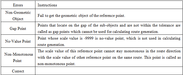
- Errors field: Enter or select the field where Errors is saved. Errors are saved in this field if an error occurs during route creation. After the Route Dataset is generated using the Line Reference Point Measure method, the Application automatically adds the error field to the Reference Point Dataset's property sheet, Store Generate RouteErrors for easy tracing of the cause of the error. The following table lists the possible Errors and their meanings:
- Tolerance: The given tolerance range. Reference points that are outside the tolerance range are not considered points on the route and will not be used to calculate the scale values for the route. For details, please refer to the description of Line Reference Point Measure Generation Method in Instructions for use on this page. The default value of Tolerance is related to the coordinate system of the Dataset. Please refer to the tolerance description .
- Result: Set the generated Route Data result. It is required to set the Datasource saved by Route Data and the name of Route Dataset.
- When you are ready, click the Execute button to perform this step.
Edit the route
Object Editing of the generated Route Dataset is supported. Supported Object Editing operations include: Line Split, Polygon Split, Select Object Split, Break, Accurate Split, Smooth, Resample, Merge, Connect Line, etc. Please refer to the Edit the object for detailed operations of Object Editing.
Note: After the LineM is extended, the user needs to Calibrate the M value of the extended part according to the length of the extended object.